Marley Creek Topo Map Oregon
To zoom in, hover over the map of Marley Creek
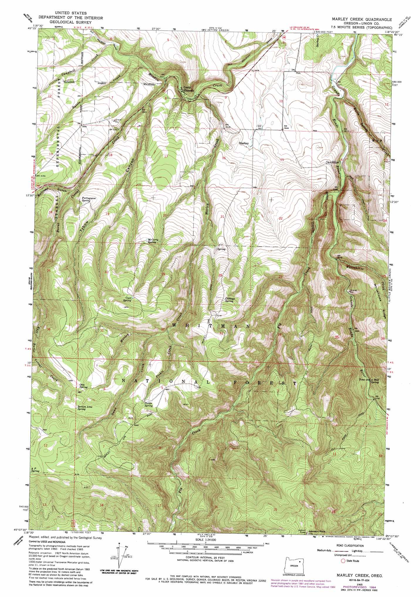
USGS Topo Quad 45118b4 - 1:24,000 scale
| Topo Map Name: | Marley Creek |
| USGS Topo Quad ID: | 45118b4 |
| Print Size: | ca. 21 1/4" wide x 27" high |
| Southeast Coordinates: | 45.125° N latitude / 118.375° W longitude |
| Map Center Coordinates: | 45.1875° N latitude / 118.4375° W longitude |
| U.S. State: | OR |
| Filename: | o45118b4.jpg |
| Download Map JPG Image: | Marley Creek topo map 1:24,000 scale |
| Map Type: | Topographic |
| Topo Series: | 7.5´ |
| Map Scale: | 1:24,000 |
| Source of Map Images: | United States Geological Survey (USGS) |
| Alternate Map Versions: |
Marley Creek OR 1965, updated 1967 Download PDF Buy paper map Marley Creek OR 1965, updated 1985 Download PDF Buy paper map Marley Creek OR 2011 Download PDF Buy paper map Marley Creek OR 2014 Download PDF Buy paper map |
| FStopo: | US Forest Service topo Marley Creek is available: Download FStopo PDF Download FStopo TIF |
1:24,000 Topo Quads surrounding Marley Creek
Sevenmile Creek |
Bassey Creek |
Meacham Lake |
Huron |
Drumhill Ridge |
Tamarack Gulch |
Bally Mountain |
Mcintyre Creek |
Kamela Se |
Hilgard |
Lehman Springs |
Sullivan Gulch |
Marley Creek |
Little Beaver Creek |
La Grande Reservoir |
Pearson Ridge |
Tower Mountain |
Fly Valley |
Limber Jim Creek |
Anthony Butte |
Kelsay Butte |
Silver Butte |
Trout Meadows |
Crawfish Lake |
Anthony Lakes |
> Back to 45118a1 at 1:100,000 scale
> Back to 45118a1 at 1:250,000 scale
> Back to U.S. Topo Maps home
Marley Creek topo map: Gazetteer
Marley Creek: Populated Places
Camp Elkanah elevation 1065m 3494′Starkey elevation 1127m 3697′
Marley Creek: Post Offices
Starkey Post Office (historical) elevation 1127m 3697′Marley Creek: Ridges
Fly Ridge elevation 1543m 5062′Marley Creek: Springs
Blue Mountain Spring elevation 1085m 3559′Cabbage Spring elevation 1397m 4583′
Coon Spring elevation 1439m 4721′
McCarty Spring elevation 1316m 4317′
Otis Spring elevation 1486m 4875′
Pickle Spring elevation 1464m 4803′
Portuguese Spring elevation 1255m 4117′
Section Line Spring elevation 1512m 4960′
Time and a Half Spring elevation 1149m 3769′
Marley Creek: Streams
Battle Creek elevation 1081m 3546′Burnt Corral Creek elevation 1073m 3520′
Campbell Creek elevation 1089m 3572′
East Burnt Corral Creek elevation 1301m 4268′
Fly Creek elevation 1057m 3467′
Marley Creek elevation 1057m 3467′
Pickle Creek elevation 1300m 4265′
Swan Creek elevation 1311m 4301′
Warm Spring Creek elevation 1031m 3382′
Whitehorse Creek elevation 1088m 3569′
Marley Creek: Summits
Johnson Rock elevation 1739m 5705′Marley Creek: Valleys
Sullivan Gulch elevation 1189m 3900′Tybow Canyon elevation 1095m 3592′
Marley Creek digital topo map on disk
Buy this Marley Creek topo map showing relief, roads, GPS coordinates and other geographical features, as a high-resolution digital map file on DVD: