Madison Butte Topo Map Oregon
To zoom in, hover over the map of Madison Butte
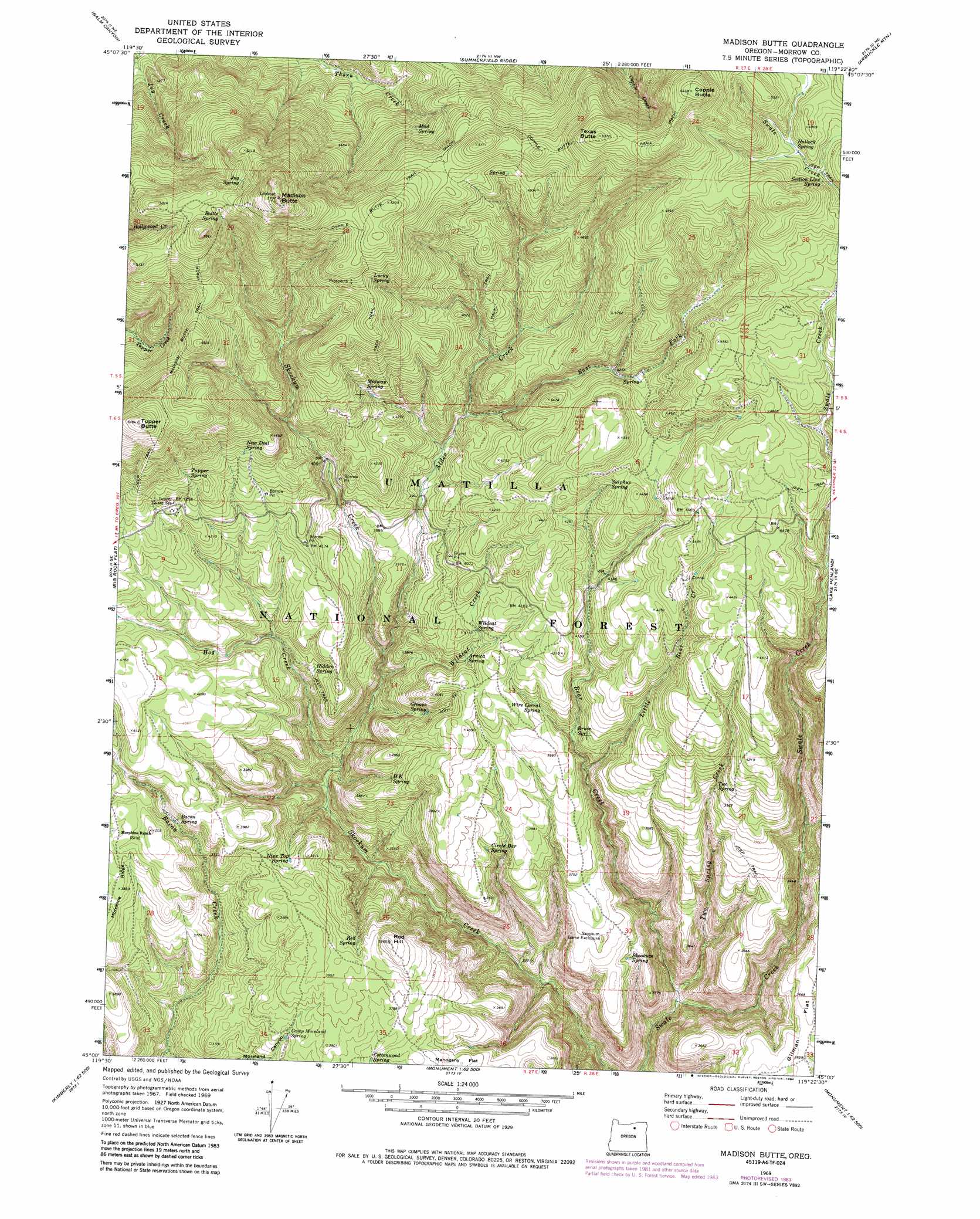
USGS Topo Quad 45119a4 - 1:24,000 scale
| Topo Map Name: | Madison Butte |
| USGS Topo Quad ID: | 45119a4 |
| Print Size: | ca. 21 1/4" wide x 27" high |
| Southeast Coordinates: | 45° N latitude / 119.375° W longitude |
| Map Center Coordinates: | 45.0625° N latitude / 119.4375° W longitude |
| U.S. State: | OR |
| Filename: | o45119a4.jpg |
| Download Map JPG Image: | Madison Butte topo map 1:24,000 scale |
| Map Type: | Topographic |
| Topo Series: | 7.5´ |
| Map Scale: | 1:24,000 |
| Source of Map Images: | United States Geological Survey (USGS) |
| Alternate Map Versions: |
Madison Butte OR 1969, updated 1973 Download PDF Buy paper map Madison Butte OR 1969, updated 1984 Download PDF Buy paper map Madison Butte OR 1995, updated 1998 Download PDF Buy paper map Madison Butte OR 2011 Download PDF Buy paper map Madison Butte OR 2014 Download PDF Buy paper map |
| FStopo: | US Forest Service topo Madison Butte is available: Download FStopo PDF Download FStopo TIF |
1:24,000 Topo Quads surrounding Madison Butte
Ruggs |
Heppner |
Skinners Fork |
Freezeout Ridge |
Hoodlum Canyon |
Hardman |
Balm Canyon |
Summerfield Ridge |
Arbuckle Mountain |
Matlock Prairie |
Chapin Creek |
Big Rock Flat |
Madison Butte |
Lake Penland |
Thompson Flat |
Whitetail Butte |
Turner Mountain |
Johnny Cake Mountain |
Slickear Mountain |
Ritter |
Kimberly |
Bologna Basin |
Monument |
Steet Mountain |
Bullock Gulch |
> Back to 45119a1 at 1:100,000 scale
> Back to 45118a1 at 1:250,000 scale
> Back to U.S. Topo Maps home
Madison Butte topo map: Gazetteer
Madison Butte: Flats
Mahogany Flat elevation 1137m 3730′Madison Butte: Springs
Arnica Spring elevation 1214m 3982′Bacon Spring elevation 1178m 3864′
Bottle Spring elevation 1533m 5029′
Brum Spring elevation 1176m 3858′
Camp Moreland Spring elevation 1132m 3713′
Circle Bar Spring elevation 1164m 3818′
Cottonwood Spring elevation 1135m 3723′
Grouse Spring elevation 1178m 3864′
H K Spring elevation 1166m 3825′
Hallock Spring elevation 1449m 4753′
Hidden Spring elevation 1181m 3874′
Jug Spring elevation 1569m 5147′
Lucky Spring elevation 1502m 4927′
Midway Spring elevation 1304m 4278′
Mud Spring elevation 1411m 4629′
New Deal Spring elevation 1360m 4461′
Nine Top Spring elevation 1140m 3740′
Red Spring elevation 1151m 3776′
Section Line Spring elevation 1452m 4763′
Skookum Spring elevation 1086m 3562′
Sulphur Spring elevation 1315m 4314′
Tupper Spring elevation 1349m 4425′
Two Spring elevation 1191m 3907′
Wildcat Spring elevation 1230m 4035′
Wire Corral Spring elevation 1195m 3920′
Madison Butte: Streams
Alder Creek elevation 1119m 3671′Bear Creek elevation 922m 3024′
East Fork Alder Creek elevation 1234m 4048′
Hog Creek elevation 1036m 3398′
Little Bear Creek elevation 1136m 3727′
Two Spring Creek elevation 938m 3077′
Wildcat Creek elevation 1081m 3546′
Madison Butte: Summits
Copple Butte elevation 1656m 5433′Madison Butte elevation 1740m 5708′
Red Hill elevation 1207m 3959′
Texas Butte elevation 1637m 5370′
Tupper Butte elevation 1579m 5180′
Madison Butte: Trails
Copple Butte Trail elevation 1575m 5167′Madison Butte Trail elevation 1477m 4845′
Madison Butte: Valleys
Moreland Canyon elevation 1018m 3339′Madison Butte digital topo map on disk
Buy this Madison Butte topo map showing relief, roads, GPS coordinates and other geographical features, as a high-resolution digital map file on DVD: