Sugarbowl Creek Topo Map Oregon
To zoom in, hover over the map of Sugarbowl Creek
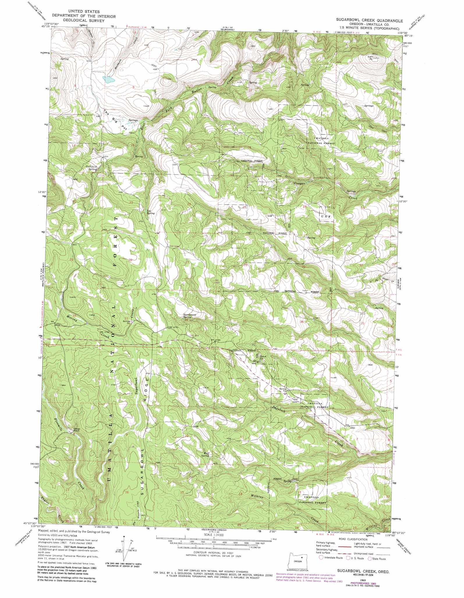
USGS Topo Quad 45119b1 - 1:24,000 scale
| Topo Map Name: | Sugarbowl Creek |
| USGS Topo Quad ID: | 45119b1 |
| Print Size: | ca. 21 1/4" wide x 27" high |
| Southeast Coordinates: | 45.125° N latitude / 119° W longitude |
| Map Center Coordinates: | 45.1875° N latitude / 119.0625° W longitude |
| U.S. State: | OR |
| Filename: | o45119b1.jpg |
| Download Map JPG Image: | Sugarbowl Creek topo map 1:24,000 scale |
| Map Type: | Topographic |
| Topo Series: | 7.5´ |
| Map Scale: | 1:24,000 |
| Source of Map Images: | United States Geological Survey (USGS) |
| Alternate Map Versions: |
Sugarbowl Creek OR 1969, updated 1973 Download PDF Buy paper map Sugarbowl Creek OR 1969, updated 1978 Download PDF Buy paper map Sugarbowl Creek OR 1969, updated 1985 Download PDF Buy paper map Sugarbowl Creek OR 1995, updated 1998 Download PDF Buy paper map Sugarbowl Creek OR 2011 Download PDF Buy paper map Sugarbowl Creek OR 2014 Download PDF Buy paper map |
| FStopo: | US Forest Service topo Sugarbowl Creek is available: Download FStopo PDF Download FStopo TIF |
1:24,000 Topo Quads surrounding Sugarbowl Creek
Lena |
Franklin Hill |
Vinson |
Nye |
Pilot Rock |
Freezeout Ridge |
Hoodlum Canyon |
Gurdane |
Carney Butte |
Granite Meadows |
Arbuckle Mountain |
Matlock Prairie |
Sugarbowl Creek |
Ukiah |
Owens Butte |
Lake Penland |
Thompson Flat |
Deerhorn Creek |
Bridge Creek |
Ukiah Se |
Slickear Mountain |
Ritter |
Meadow Brook Summit |
Dale |
The Cockscomb |
> Back to 45119a1 at 1:100,000 scale
> Back to 45118a1 at 1:250,000 scale
> Back to U.S. Topo Maps home
Sugarbowl Creek topo map: Gazetteer
Sugarbowl Creek: Flats
The Big Pot elevation 1302m 4271′Sugarbowl Creek: Ridges
Sugarbowl Ridge elevation 1435m 4708′Sugarbowl Creek: Springs
Forest Spring elevation 1260m 4133′Gulliford Spring elevation 1384m 4540′
Log Spring elevation 1427m 4681′
Sturdevant Spring elevation 1423m 4668′
Wolf Spring elevation 1363m 4471′
Sugarbowl Creek: Streams
Morsay Creek elevation 1427m 4681′Sugarbowl Creek elevation 1369m 4491′
Sugarbowl Creek: Summits
Battle Mountain elevation 1375m 4511′Sugarbowl Creek digital topo map on disk
Buy this Sugarbowl Creek topo map showing relief, roads, GPS coordinates and other geographical features, as a high-resolution digital map file on DVD: