Matlock Prairie Topo Map Oregon
To zoom in, hover over the map of Matlock Prairie
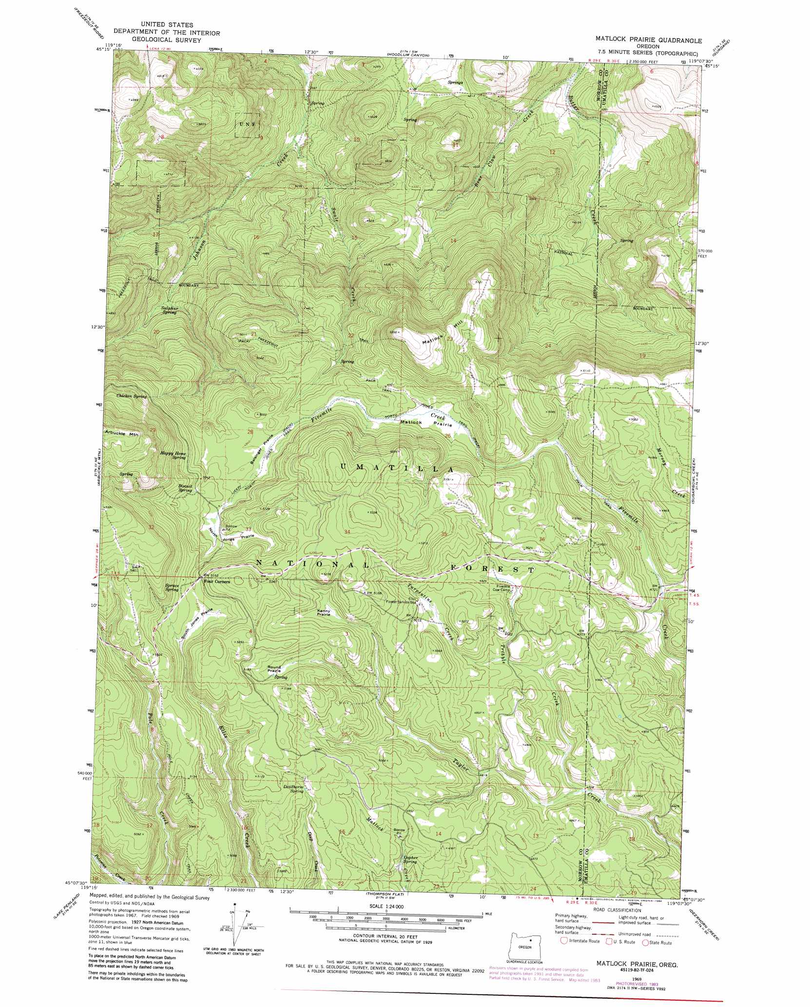
USGS Topo Quad 45119b2 - 1:24,000 scale
| Topo Map Name: | Matlock Prairie |
| USGS Topo Quad ID: | 45119b2 |
| Print Size: | ca. 21 1/4" wide x 27" high |
| Southeast Coordinates: | 45.125° N latitude / 119.125° W longitude |
| Map Center Coordinates: | 45.1875° N latitude / 119.1875° W longitude |
| U.S. State: | OR |
| Filename: | o45119b2.jpg |
| Download Map JPG Image: | Matlock Prairie topo map 1:24,000 scale |
| Map Type: | Topographic |
| Topo Series: | 7.5´ |
| Map Scale: | 1:24,000 |
| Source of Map Images: | United States Geological Survey (USGS) |
| Alternate Map Versions: |
Matlock Prairie OR 1969, updated 1973 Download PDF Buy paper map Matlock Prairie OR 1969, updated 1984 Download PDF Buy paper map Matlock Prairie OR 1995, updated 1998 Download PDF Buy paper map Matlock Prairie OR 2011 Download PDF Buy paper map Matlock Prairie OR 2014 Download PDF Buy paper map |
| FStopo: | US Forest Service topo Matlock Prairie is available: Download FStopo PDF Download FStopo TIF |
1:24,000 Topo Quads surrounding Matlock Prairie
Gleason Butte |
Lena |
Franklin Hill |
Vinson |
Nye |
Skinners Fork |
Freezeout Ridge |
Hoodlum Canyon |
Gurdane |
Carney Butte |
Summerfield Ridge |
Arbuckle Mountain |
Matlock Prairie |
Sugarbowl Creek |
Ukiah |
Madison Butte |
Lake Penland |
Thompson Flat |
Deerhorn Creek |
Bridge Creek |
Johnny Cake Mountain |
Slickear Mountain |
Ritter |
Meadow Brook Summit |
Dale |
> Back to 45119a1 at 1:100,000 scale
> Back to 45118a1 at 1:250,000 scale
> Back to U.S. Topo Maps home
Matlock Prairie topo map: Gazetteer
Matlock Prairie: Areas
Arbuckle Ski Area elevation 1609m 5278′Matlock Prairie: Flats
Balsinger Prairie elevation 1507m 4944′Kenny Prairie elevation 1542m 5059′
Matlock Prairie elevation 1493m 4898′
North Jones Prairie elevation 1525m 5003′
Round Prairie elevation 1554m 5098′
South Jones Prairie elevation 1559m 5114′
Matlock Prairie: Springs
Biscuit Spring elevation 1543m 5062′Chicken Spring elevation 1555m 5101′
Deadhorse Spring elevation 1535m 5036′
Gopher Spring elevation 1487m 4878′
Happy Home Spring elevation 1542m 5059′
Spruce Spring elevation 1573m 5160′
Sulphur Spring elevation 1283m 4209′
Matlock Prairie: Streams
Bear Claw Creek elevation 1147m 3763′Swale Creek elevation 1152m 3779′
Tribble Creek elevation 1442m 4730′
Turpentine Creek elevation 1479m 4852′
Matlock Prairie: Summits
Matlock Hill elevation 1620m 5314′Matlock Prairie: Trails
Freezeout Trail elevation 1313m 4307′North Jones Trail elevation 1587m 5206′
Pole Creek Trail elevation 1546m 5072′
Matlock Prairie digital topo map on disk
Buy this Matlock Prairie topo map showing relief, roads, GPS coordinates and other geographical features, as a high-resolution digital map file on DVD: