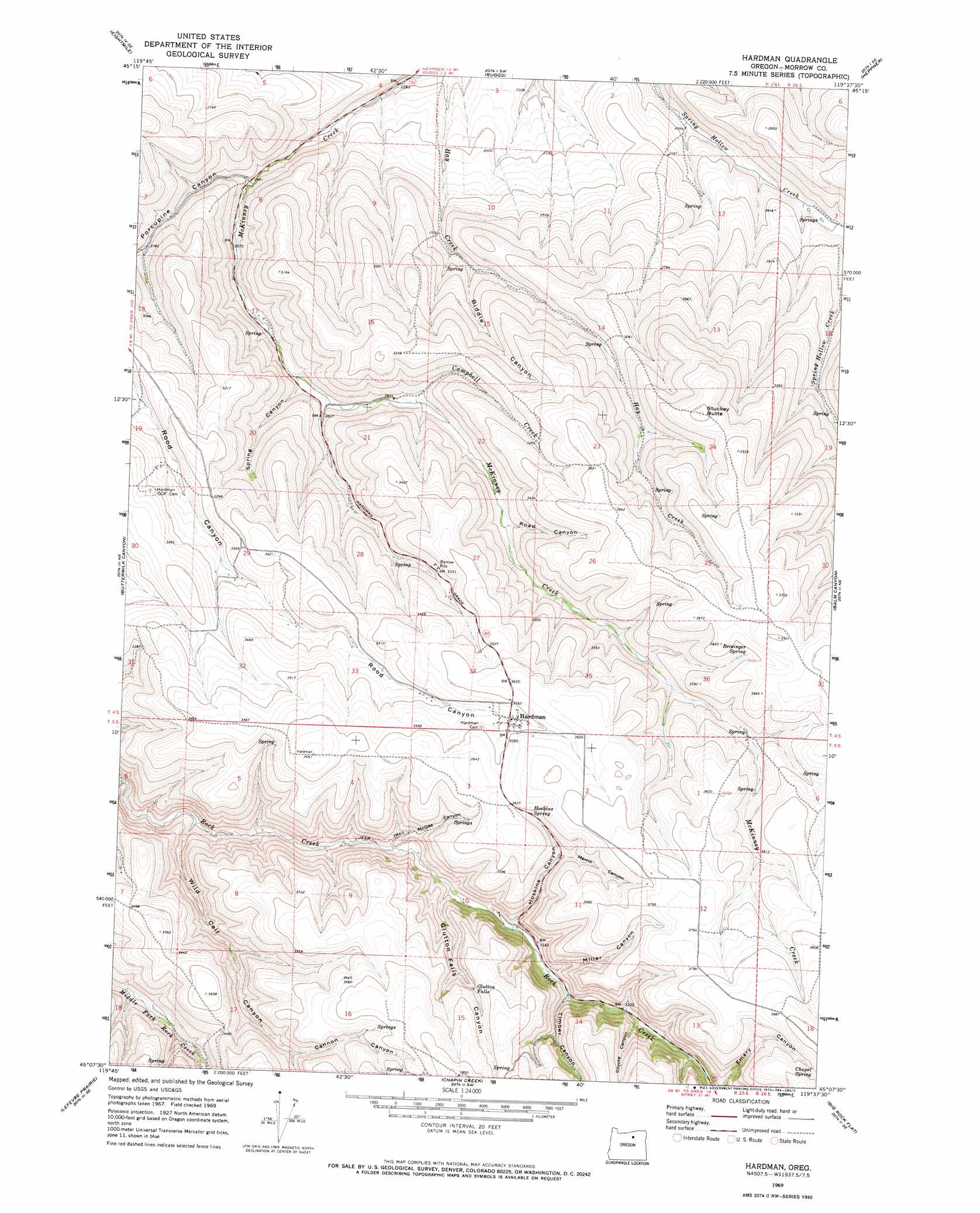
Hardman Topo Map Oregon
To zoom in, hover over the map of Hardman
USGS Topo Quad 45119b6 - 1:24,000 scale
| Topo Map Name: | Hardman |
| USGS Topo Quad ID: | 45119b6 |
| Print Size: | ca. 21 1/4" wide x 27" high |
| Southeast Coordinates: | 45.125° N latitude / 119.625° W longitude |
| Map Center Coordinates: | 45.1875° N latitude / 119.6875° W longitude |
| U.S. State: | OR |
| Filename: | o45119b6.jpg |
| Download Map JPG Image: | Hardman topo map 1:24,000 scale |
| Map Type: | Topographic |
| Topo Series: | 7.5´ |
| Map Scale: | 1:24,000 |
| Source of Map Images: | United States Geological Survey (USGS) |
| Alternate Map Versions: |
Hardman OR 1969, updated 1973 Download PDF Buy paper map Hardman OR 2011 Download PDF Buy paper map Hardman OR 2014 Download PDF Buy paper map |
1:24,000 Topo Quads surrounding Hardman
Utts Butte |
Ione South |
Lexington |
Swaggart Buttes |
Gleason Butte |
Gooseberry |
Eightmile |
Ruggs |
Heppner |
Skinners Fork |
Lone Rock Creek |
Buttermilk Canyon |
Hardman |
Balm Canyon |
Summerfield Ridge |
Lonerock |
Lefevre Prairie |
Chapin Creek |
Big Rock Flat |
Madison Butte |
Wheeler Point |
Collins Butte |
Whitetail Butte |
Turner Mountain |
Johnny Cake Mountain |
> Back to 45119a1 at 1:100,000 scale
> Back to 45118a1 at 1:250,000 scale
> Back to U.S. Topo Maps home
Hardman topo map: Gazetteer
Hardman: Falls
Glutton Falls elevation 1081m 3546′Hardman: Populated Places
Hardman (historical) elevation 1086m 3562′Hardman: Post Offices
Adamsville Post Office (historical) elevation 1038m 3405′Hardman Post Office (historical) elevation 1086m 3562′
Hardman: Reservoirs
Stuckey Butte Reservoir elevation 913m 2995′Hardman: Slopes
Deadman Hill elevation 1069m 3507′Hardman: Springs
Chapel Spring elevation 1163m 3815′Hoskins Spring elevation 1083m 3553′
Reininger Spring elevation 1091m 3579′
Hardman: Streams
Campbell Creek elevation 872m 2860′Hardman: Summits
Stuckey Butte elevation 1073m 3520′Hardman: Valleys
Biddle Canyon elevation 821m 2693′Buck Canyon elevation 998m 3274′
Cannon Canyon elevation 1033m 3389′
Coyote Canyon elevation 983m 3225′
Glutton Falls Canyon elevation 935m 3067′
Hoskins Canyon elevation 967m 3172′
McGee Canyon elevation 921m 3021′
Merrill Canyon elevation 1042m 3418′
Miller Canyon elevation 962m 3156′
Porcupine Canyon elevation 756m 2480′
Road Canyon elevation 935m 3067′
Spring Canyon elevation 830m 2723′
Timber Canyon elevation 977m 3205′
Wild Calf Canyon elevation 886m 2906′
Hardman digital topo map on disk
Buy this Hardman topo map showing relief, roads, GPS coordinates and other geographical features, as a high-resolution digital map file on DVD: