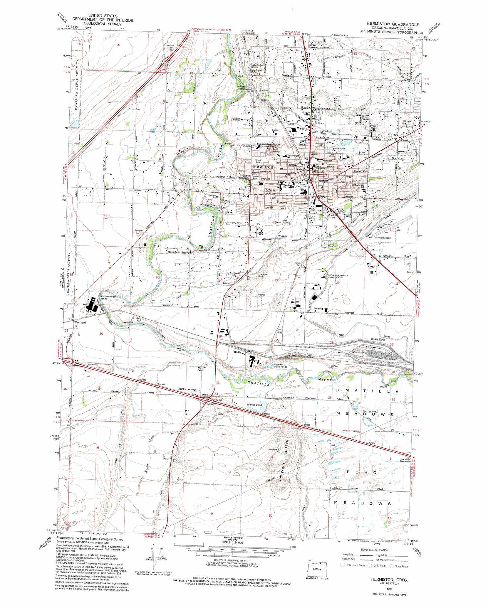
Hermiston Topo Map Oregon
To zoom in, hover over the map of Hermiston
USGS Topo Quad 45119g3 - 1:24,000 scale
| Topo Map Name: | Hermiston |
| USGS Topo Quad ID: | 45119g3 |
| Print Size: | ca. 21 1/4" wide x 27" high |
| Southeast Coordinates: | 45.75° N latitude / 119.25° W longitude |
| Map Center Coordinates: | 45.8125° N latitude / 119.3125° W longitude |
| U.S. State: | OR |
| Filename: | o45119g3.jpg |
| Download Map JPG Image: | Hermiston topo map 1:24,000 scale |
| Map Type: | Topographic |
| Topo Series: | 7.5´ |
| Map Scale: | 1:24,000 |
| Source of Map Images: | United States Geological Survey (USGS) |
| Alternate Map Versions: |
Hermiston OR 1962, updated 1963 Download PDF Buy paper map Hermiston OR 1962, updated 1972 Download PDF Buy paper map Hermiston OR 1962, updated 1978 Download PDF Buy paper map Hermiston OR 1962, updated 1987 Download PDF Buy paper map Hermiston OR 1993, updated 1993 Download PDF Buy paper map Hermiston OR 2011 Download PDF Buy paper map Hermiston OR 2014 Download PDF Buy paper map |
1:24,000 Topo Quads surrounding Hermiston
Whitstran Se |
Prior Ranch |
Taylor Canyon |
Johnson Butte |
Nine Canyon |
Paterson |
Irrigon |
Umatilla |
Hat Rock |
Juniper |
Clarke |
Ordnance |
Hermiston |
Stanfield |
Stanfield Se |
Strawberry Canyon Ne |
Ward Butte |
Service Buttes |
Echo |
Nolin |
Strawberry Canyon Se |
Butter Creek Junction |
Vey Ranch |
Echo Sw |
Echo Se |
> Back to 45119e1 at 1:100,000 scale
> Back to 45118a1 at 1:250,000 scale
> Back to U.S. Topo Maps home
Hermiston topo map: Gazetteer
Hermiston: Airports
Hermiston Municipal Airport elevation 195m 639′Hermiston: Bends
Cottonwood Bend elevation 163m 534′Hermiston: Canals
A Line Canal elevation 171m 561′Courtney Ditch elevation 175m 574′
Dillon Ditch elevation 171m 561′
Feed Canal elevation 194m 636′
Hermiston Ditch elevation 135m 442′
High Line Canal elevation 189m 620′
I Canal elevation 152m 498′
Maxwell Canal elevation 160m 524′
N Canal elevation 152m 498′
R-3 Pipe elevation 165m 541′
Westland A Canal elevation 171m 561′
Westland F Canal elevation 163m 534′
Z Canal elevation 164m 538′
Hermiston: Flats
Echo Meadows elevation 179m 587′Umatilla Meadows elevation 172m 564′
Hermiston: Lakes
Manns Pond elevation 167m 547′Hermiston: Parks
Belt Park elevation 138m 452′Butte Park elevation 157m 515′
Doctor Belt Park elevation 138m 452′
Hermiston State Game Farm elevation 171m 561′
Highland Park elevation 142m 465′
Hodge Park elevation 144m 472′
McKenzie Park elevation 139m 456′
Newport Park elevation 138m 452′
Northside Park elevation 139m 456′
Riverfront Park elevation 136m 446′
Steelhead Park elevation 146m 479′
Sunset Park elevation 137m 449′
Theater Sports Park elevation 136m 446′
Victory Square Park elevation 140m 459′
Volunteer Park elevation 137m 449′
Hermiston: Populated Places
Bucks Corners elevation 168m 551′Hermiston elevation 140m 459′
Hinkle elevation 189m 620′
Hermiston: Post Offices
Hermiston Post Office elevation 140m 459′Meadows Post Office (historical) elevation 195m 639′
Westland Post Office (historical) elevation 174m 570′
Hermiston: Reservoirs
Wink Pond elevation 165m 541′Hermiston: Springs
Minnehaha Spring elevation 155m 508′Sullivan Spring elevation 166m 544′
Hermiston: Streams
Butter Creek elevation 163m 534′Hermiston: Summits
Emigrant Buttes elevation 228m 748′Hermiston Butte elevation 177m 580′
Hermiston digital topo map on disk
Buy this Hermiston topo map showing relief, roads, GPS coordinates and other geographical features, as a high-resolution digital map file on DVD: