Shoestring Ridge Topo Map Oregon
To zoom in, hover over the map of Shoestring Ridge
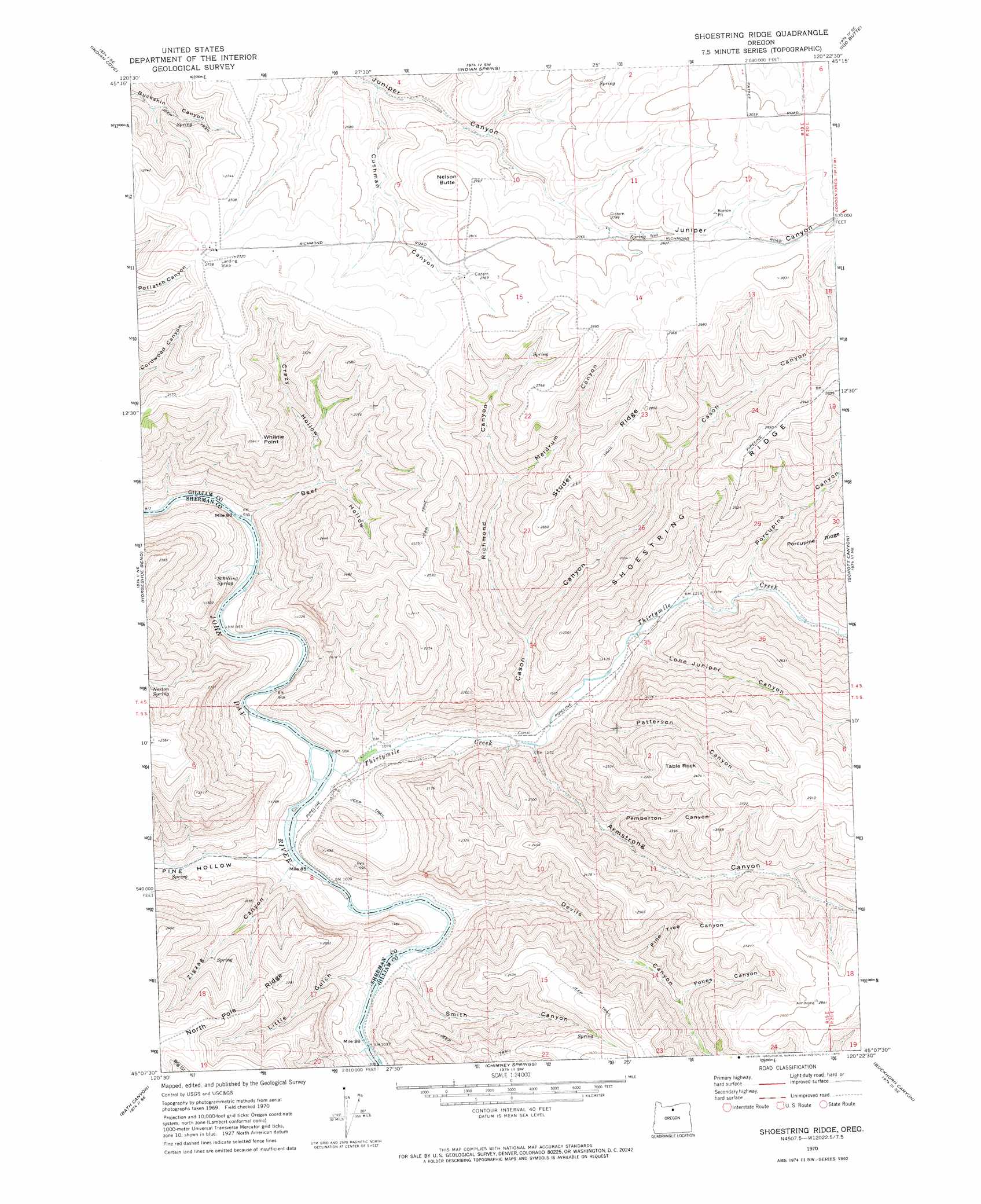
USGS Topo Quad 45120b4 - 1:24,000 scale
| Topo Map Name: | Shoestring Ridge |
| USGS Topo Quad ID: | 45120b4 |
| Print Size: | ca. 21 1/4" wide x 27" high |
| Southeast Coordinates: | 45.125° N latitude / 120.375° W longitude |
| Map Center Coordinates: | 45.1875° N latitude / 120.4375° W longitude |
| U.S. State: | OR |
| Filename: | o45120b4.jpg |
| Download Map JPG Image: | Shoestring Ridge topo map 1:24,000 scale |
| Map Type: | Topographic |
| Topo Series: | 7.5´ |
| Map Scale: | 1:24,000 |
| Source of Map Images: | United States Geological Survey (USGS) |
| Alternate Map Versions: |
Shoestring Ridge OR 1970, updated 1973 Download PDF Buy paper map Shoestring Ridge OR 2011 Download PDF Buy paper map Shoestring Ridge OR 2014 Download PDF Buy paper map |
1:24,000 Topo Quads surrounding Shoestring Ridge
Moro |
Harmony |
Esau Canyon |
Devils Backbone |
Mikkalo |
Rosebush |
Indian Cove |
Indian Spring |
Igo Butte |
Gwendolen |
Kent |
Horseshoe Bend |
Shoestring Ridge |
Schott Canyon |
Condon |
Macken Canyon |
Bath Canyon |
Chimney Springs |
Buckhorn Canyon |
Fossil North |
Antelope |
Hastings Peak |
Clarno |
Porcupine Butte |
Fossil South |
> Back to 45120a1 at 1:100,000 scale
> Back to 45120a1 at 1:250,000 scale
> Back to U.S. Topo Maps home
Shoestring Ridge topo map: Gazetteer
Shoestring Ridge: Ridges
Shoestring Ridge elevation 895m 2936′Studer Ridge elevation 847m 2778′
Shoestring Ridge: Springs
Schilling Spring elevation 374m 1227′Shoestring Ridge: Streams
Thirtymile Creek elevation 300m 984′Shoestring Ridge: Summits
Nelson Butte elevation 871m 2857′Table Rock elevation 786m 2578′
Whistle Point elevation 784m 2572′
Shoestring Ridge: Valleys
Armstrong Canyon elevation 352m 1154′Beef Hollow elevation 294m 964′
Cason Canyon elevation 343m 1125′
Crazy Hollow elevation 409m 1341′
Cushman Canyon elevation 702m 2303′
Devils Canyon elevation 315m 1033′
Fones Canyon elevation 563m 1847′
Little Gulch elevation 326m 1069′
Lone Juniper Canyon elevation 380m 1246′
Meldrum Canyon elevation 578m 1896′
Patterson Canyon elevation 349m 1145′
Pemberton Canyon elevation 482m 1581′
Pine Hollow elevation 304m 997′
Pine Tree Canyon elevation 526m 1725′
Porcupine Canyon elevation 408m 1338′
Richmond Canyon elevation 413m 1354′
Smith Canyon elevation 324m 1062′
Zigzag Canyon elevation 337m 1105′
Shoestring Ridge digital topo map on disk
Buy this Shoestring Ridge topo map showing relief, roads, GPS coordinates and other geographical features, as a high-resolution digital map file on DVD: