Wishram Topo Map Washington
To zoom in, hover over the map of Wishram
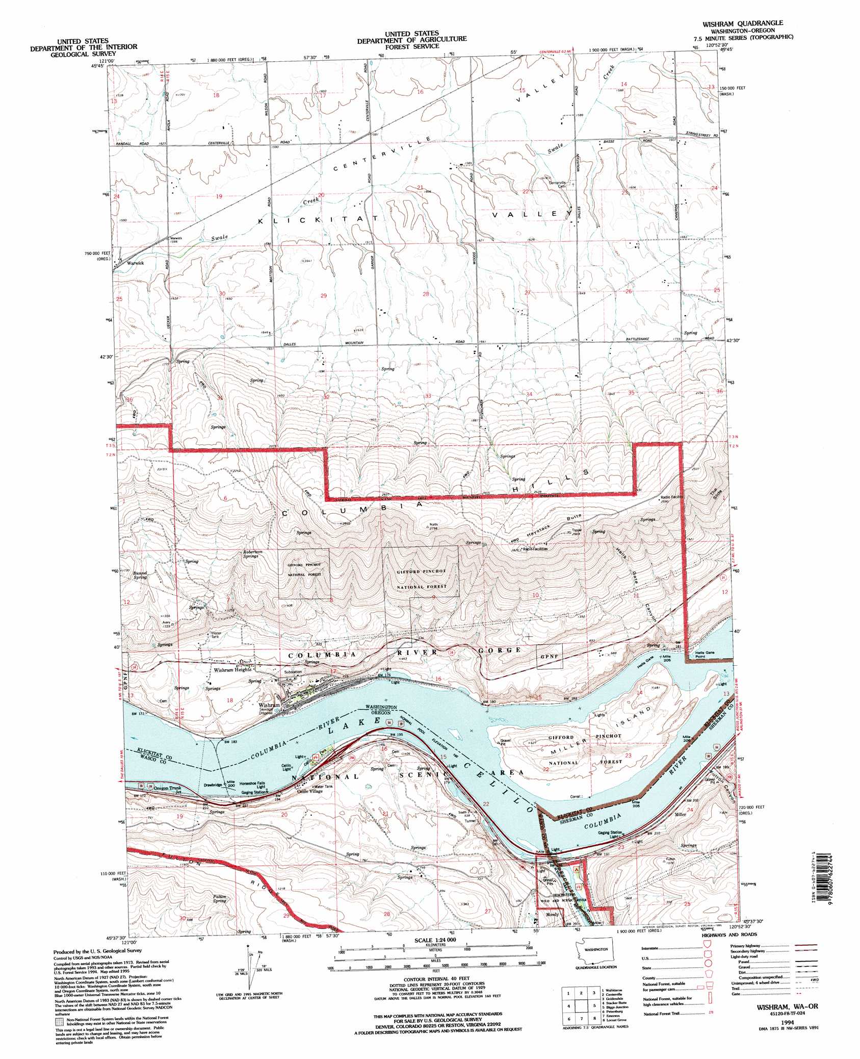
USGS Topo Quad 45120f8 - 1:24,000 scale
| Topo Map Name: | Wishram |
| USGS Topo Quad ID: | 45120f8 |
| Print Size: | ca. 21 1/4" wide x 27" high |
| Southeast Coordinates: | 45.625° N latitude / 120.875° W longitude |
| Map Center Coordinates: | 45.6875° N latitude / 120.9375° W longitude |
| U.S. States: | WA, OR |
| Filename: | o45120f8.jpg |
| Download Map JPG Image: | Wishram topo map 1:24,000 scale |
| Map Type: | Topographic |
| Topo Series: | 7.5´ |
| Map Scale: | 1:24,000 |
| Source of Map Images: | United States Geological Survey (USGS) |
| Alternate Map Versions: |
Wishram WA 1977, updated 1977 Download PDF Buy paper map Wishram WA 1994, updated 1995 Download PDF Buy paper map Wishram WA 2011 Download PDF Buy paper map Wishram WA 2014 Download PDF Buy paper map |
| FStopo: | US Forest Service topo Wishram is available: Download FStopo PDF Download FStopo TIF |
1:24,000 Topo Quads surrounding Wishram
Dead Canyon |
Grayback Mountain |
White Pine Buttes |
Indian Rock |
Status Pass |
Klickitat |
Wahkiacus |
Centerville |
Goldendale |
Luna Butte |
The Dalles North |
Stacker Butte |
Wishram |
Biggs Junction |
Rufus |
The Dalles South |
Petersburg |
Emerson |
Locust Grove |
Wasco |
Dufur West |
Dufur East |
Summit Ridge |
Erskine |
Moro |
> Back to 45120e1 at 1:100,000 scale
> Back to 45120a1 at 1:250,000 scale
> Back to U.S. Topo Maps home
Wishram topo map: Gazetteer
Wishram: Capes
Hells Gate Point elevation 50m 164′Wishram: Channels
Hells Gate elevation 50m 164′South Channel elevation 50m 164′
South Channel elevation 50m 164′
South Channel Range B elevation 50m 164′
South Channel Range C elevation 50m 164′
Wishram: Cliffs
The Slide elevation 581m 1906′Wishram: Falls
Celilo Falls (historical) elevation 50m 164′Wishram: Islands
Miller Island elevation 72m 236′Moody Island elevation 52m 170′
Wishram: Parks
Celilo Park elevation 52m 170′Deschutes River Scenic Waterway elevation 57m 187′
Deschutes River State Park elevation 63m 206′
Wishram: Populated Places
Celilo Village elevation 66m 216′Warwick elevation 475m 1558′
Wishram elevation 54m 177′
Wishram Heights elevation 166m 544′
Wishram: Post Offices
Celilo Post Office (historical) elevation 60m 196′Dechutes Post Office (historical) elevation 56m 183′
Deschutes Bridge Post Office (historical) elevation 56m 183′
Dillon Post Office (historical) elevation 53m 173′
Miller Post Office (historical) elevation 58m 190′
Moody Post Office (historical) elevation 91m 298′
Wishram: Springs
Bunnel Spring elevation 429m 1407′Carlisle Spring elevation 199m 652′
Patton Spring elevation 297m 974′
Robertson Springs elevation 506m 1660′
Wishram: Streams
Deschutes River elevation 50m 164′Wishram: Summits
Haystack Butte elevation 902m 2959′Wishram: Valleys
Centerville Valley elevation 476m 1561′Fulton Canyon elevation 55m 180′
Hells Gate Canyon elevation 60m 196′
Wishram digital topo map on disk
Buy this Wishram topo map showing relief, roads, GPS coordinates and other geographical features, as a high-resolution digital map file on DVD: