White Pine Buttes Topo Map Washington
To zoom in, hover over the map of White Pine Buttes
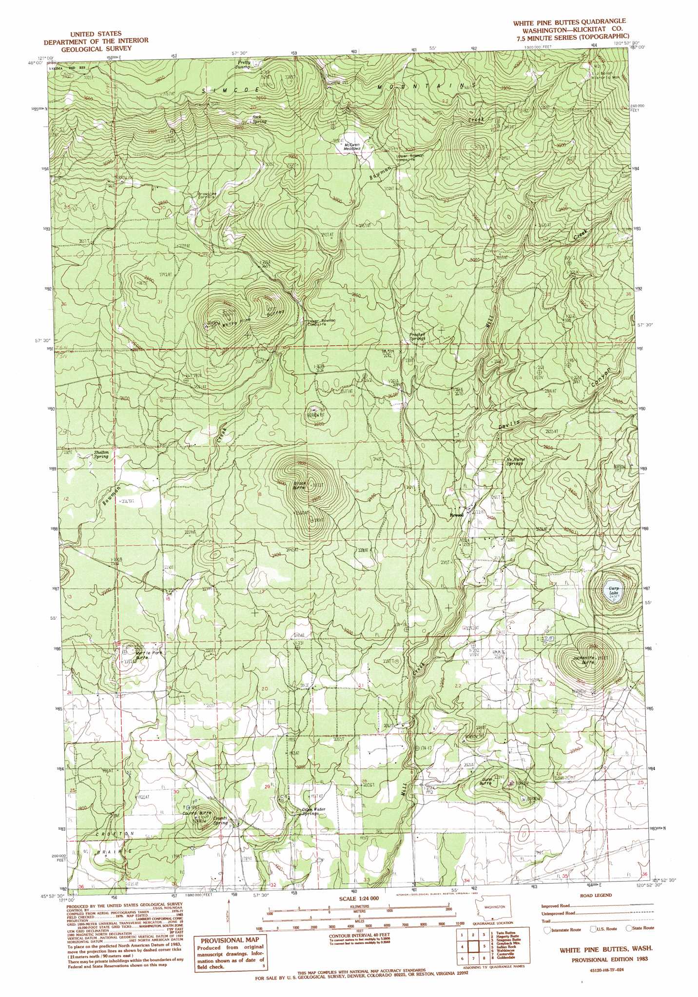
USGS Topo Quad 45120h8 - 1:24,000 scale
| Topo Map Name: | White Pine Buttes |
| USGS Topo Quad ID: | 45120h8 |
| Print Size: | ca. 21 1/4" wide x 27" high |
| Southeast Coordinates: | 45.875° N latitude / 120.875° W longitude |
| Map Center Coordinates: | 45.9375° N latitude / 120.9375° W longitude |
| U.S. State: | WA |
| Filename: | o45120h8.jpg |
| Download Map JPG Image: | White Pine Buttes topo map 1:24,000 scale |
| Map Type: | Topographic |
| Topo Series: | 7.5´ |
| Map Scale: | 1:24,000 |
| Source of Map Images: | United States Geological Survey (USGS) |
| Alternate Map Versions: |
White Pine Buttes WA 1983, updated 1983 Download PDF Buy paper map White Pine Buttes WA 2011 Download PDF Buy paper map White Pine Buttes WA 2014 Download PDF Buy paper map |
1:24,000 Topo Quads surrounding White Pine Buttes
Signal Peak |
Poland Butte |
Mckays Butte |
Camas Patch |
Logy Creek Falls |
Outlet Falls |
Twin Buttes |
Hagerty Butte |
Stagman Butte |
Logy Creek Sw |
Dead Canyon |
Grayback Mountain |
White Pine Buttes |
Indian Rock |
Status Pass |
Klickitat |
Wahkiacus |
Centerville |
Goldendale |
Luna Butte |
The Dalles North |
Stacker Butte |
Wishram |
Biggs Junction |
Rufus |
> Back to 45120e1 at 1:100,000 scale
> Back to 45120a1 at 1:250,000 scale
> Back to U.S. Topo Maps home
White Pine Buttes topo map: Gazetteer
White Pine Buttes: Flats
McEwen Meadows elevation 923m 3028′White Pine Buttes: Lakes
Carp Lake elevation 755m 2477′White Pine Buttes: Parks
A J Bolon Historic Monument elevation 1247m 4091′White Pine Buttes: Populated Places
Firwood elevation 712m 2335′White Pine Buttes: Springs
Counts Spring elevation 568m 1863′Gilen Water Springs elevation 577m 1893′
No Name Spring elevation 745m 2444′
Presher Springs elevation 820m 2690′
Rock Spring elevation 1011m 3316′
Shelton Spring elevation 696m 2283′
White Pine Buttes: Summits
Black Butte elevation 934m 3064′Counts Butte elevation 646m 2119′
Gunn Butte elevation 675m 2214′
Jackknife Butte elevation 881m 2890′
Myrtle Park Butte elevation 702m 2303′
White Pine Buttes elevation 980m 3215′
White Pine Buttes: Swamps
Pretty Swamp elevation 1104m 3622′White Pine Buttes: Valleys
Devils Canyon elevation 721m 2365′White Pine Buttes digital topo map on disk
Buy this White Pine Buttes topo map showing relief, roads, GPS coordinates and other geographical features, as a high-resolution digital map file on DVD: