Foreman Point Topo Map Oregon
To zoom in, hover over the map of Foreman Point
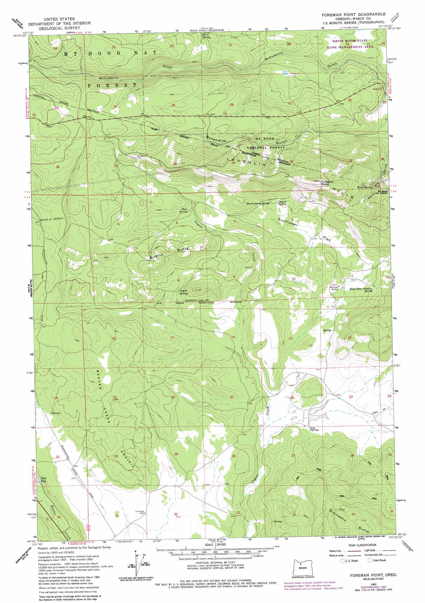
USGS Topo Quad 45121a4 - 1:24,000 scale
| Topo Map Name: | Foreman Point |
| USGS Topo Quad ID: | 45121a4 |
| Print Size: | ca. 21 1/4" wide x 27" high |
| Southeast Coordinates: | 45° N latitude / 121.375° W longitude |
| Map Center Coordinates: | 45.0625° N latitude / 121.4375° W longitude |
| U.S. State: | OR |
| Filename: | o45121a4.jpg |
| Download Map JPG Image: | Foreman Point topo map 1:24,000 scale |
| Map Type: | Topographic |
| Topo Series: | 7.5´ |
| Map Scale: | 1:24,000 |
| Source of Map Images: | United States Geological Survey (USGS) |
| Alternate Map Versions: |
Foreman Point OR 1962, updated 1964 Download PDF Buy paper map Foreman Point OR 1962, updated 1983 Download PDF Buy paper map Foreman Point OR 1962, updated 1987 Download PDF Buy paper map Foreman Point OR 1996, updated 1998 Download PDF Buy paper map Foreman Point OR 2011 Download PDF Buy paper map Foreman Point OR 2014 Download PDF Buy paper map |
| FStopo: | US Forest Service topo Foreman Point is available: Download FStopo PDF Download FStopo TIF |
1:24,000 Topo Quads surrounding Foreman Point
Mount Hood South |
Badger Lake |
Flag Point |
Friend |
Postage Stamp Butte |
Wapinitia Pass |
Post Point |
Rock Creek Reservoir |
Wamic |
Tygh Valley |
Mount Wilson |
Beaver Butte |
Foreman Point |
Wapinitia |
Maupin Sw |
Fort Butte |
Sidwalter Buttes |
Hehe Butte |
Simnasho |
Mutton Mountain |
Boulder Lake |
Sawmill Butte |
Potters Ponds |
Warm Springs |
Eagle Butte |
> Back to 45121a1 at 1:100,000 scale
> Back to 45120a1 at 1:250,000 scale
> Back to U.S. Topo Maps home
Foreman Point topo map: Gazetteer
Foreman Point: Flats
Sunflower Flat elevation 826m 2709′Foreman Point: Mines
Rainbow Quarry elevation 842m 2762′Foreman Point: Springs
Bald Peter Pasture Spring elevation 856m 2808′Coyote Spring elevation 831m 2726′
Daniel Spring elevation 854m 2801′
Deer Spring elevation 858m 2814′
Evick Spring elevation 861m 2824′
Government Spring elevation 856m 2808′
Kelly Spring elevation 837m 2746′
Log Spring elevation 797m 2614′
Foreman Point: Summits
Foreman Point elevation 1066m 3497′Laughlin Hills elevation 1041m 3415′
Quartz Butte elevation 930m 3051′
Rainbow Rock elevation 845m 2772′
Simnasho Butte elevation 1095m 3592′
Foreman Point: Valleys
Byzandine Gulch elevation 706m 2316′Foreman Point digital topo map on disk
Buy this Foreman Point topo map showing relief, roads, GPS coordinates and other geographical features, as a high-resolution digital map file on DVD: