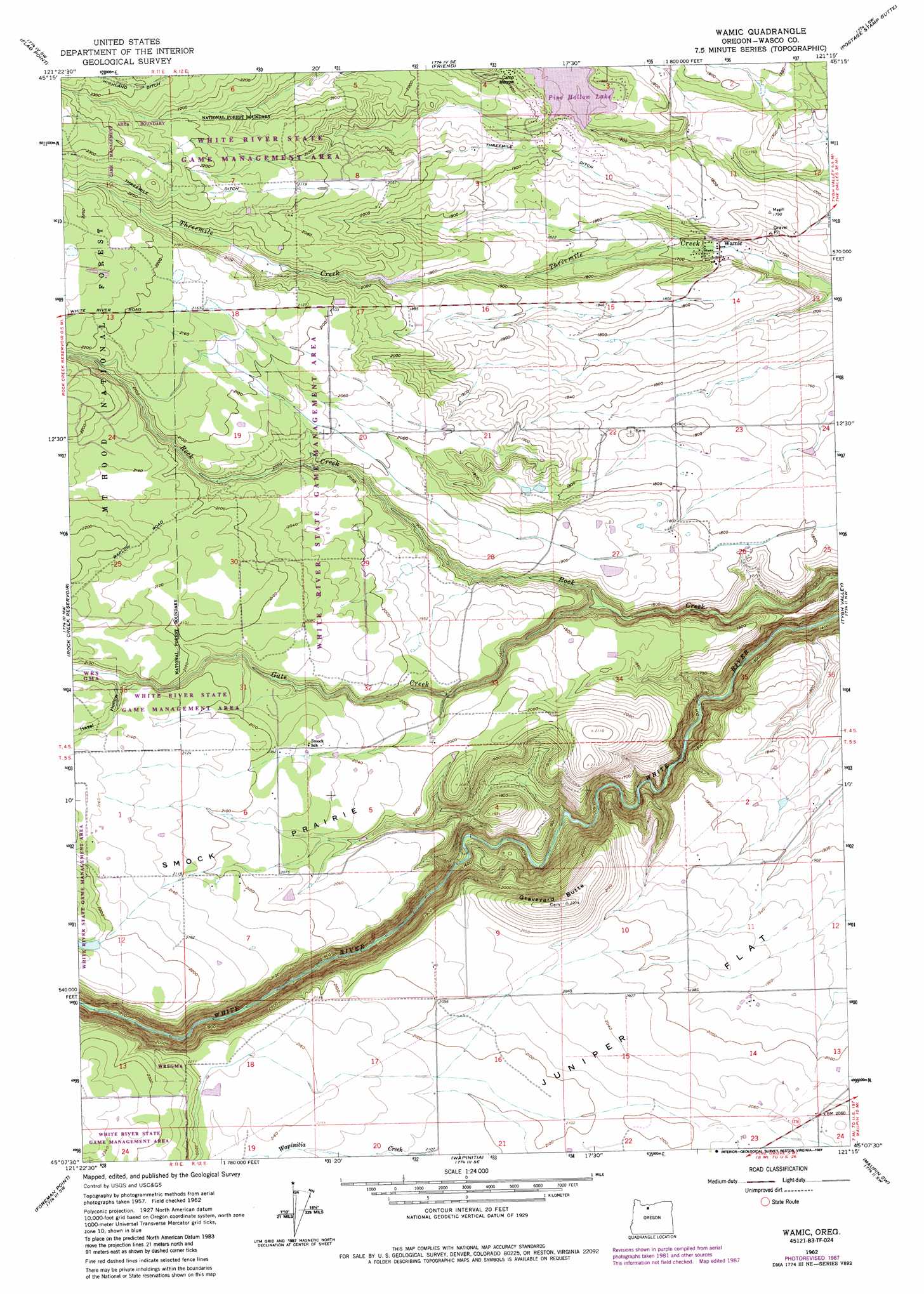
Wamic Topo Map Oregon
To zoom in, hover over the map of Wamic
USGS Topo Quad 45121b3 - 1:24,000 scale
| Topo Map Name: | Wamic |
| USGS Topo Quad ID: | 45121b3 |
| Print Size: | ca. 21 1/4" wide x 27" high |
| Southeast Coordinates: | 45.125° N latitude / 121.25° W longitude |
| Map Center Coordinates: | 45.1875° N latitude / 121.3125° W longitude |
| U.S. State: | OR |
| Filename: | o45121b3.jpg |
| Download Map JPG Image: | Wamic topo map 1:24,000 scale |
| Map Type: | Topographic |
| Topo Series: | 7.5´ |
| Map Scale: | 1:24,000 |
| Source of Map Images: | United States Geological Survey (USGS) |
| Alternate Map Versions: |
Wamic OR 1962, updated 1964 Download PDF Buy paper map Wamic OR 1962, updated 1974 Download PDF Buy paper map Wamic OR 1962, updated 1983 Download PDF Buy paper map Wamic OR 1962, updated 1987 Download PDF Buy paper map Wamic OR 1996, updated 1998 Download PDF Buy paper map Wamic OR 2011 Download PDF Buy paper map Wamic OR 2014 Download PDF Buy paper map |
| FStopo: | US Forest Service topo Wamic is available: Download FStopo PDF Download FStopo TIF |
1:24,000 Topo Quads surrounding Wamic
Dog River |
Fivemile Butte |
Wolf Run |
Dufur West |
Dufur East |
Badger Lake |
Flag Point |
Friend |
Postage Stamp Butte |
Sherars Bridge |
Post Point |
Rock Creek Reservoir |
Wamic |
Tygh Valley |
Maupin |
Beaver Butte |
Foreman Point |
Wapinitia |
Maupin Sw |
Dant |
Sidwalter Buttes |
Hehe Butte |
Simnasho |
Mutton Mountain |
Kaskela |
> Back to 45121a1 at 1:100,000 scale
> Back to 45120a1 at 1:250,000 scale
> Back to U.S. Topo Maps home
Wamic topo map: Gazetteer
Wamic: Benches
Hill Bench elevation 650m 2132′Wamic: Canals
Rock Creek Ditch elevation 590m 1935′Threemile Ditch elevation 637m 2089′
Wamic: Dams
Miller Dam elevation 681m 2234′Pine Hollow Dam elevation 563m 1847′
Wamic: Flats
Smock Prairie elevation 654m 2145′Wamic: Lakes
Cody Ponds elevation 665m 2181′Wamic: Populated Places
Pine Hollow elevation 575m 1886′Wamic elevation 511m 1676′
Wamic: Post Offices
Smock Post Office (historical) elevation 637m 2089′Wamic Post Office elevation 511m 1676′
Wamic: Reservoirs
Pine Hollow Reservoir elevation 558m 1830′Wamic: Streams
Gate Creek elevation 517m 1696′Wamic: Summits
Graveyard Butte elevation 710m 2329′Wamic: Valleys
Hazel Hollow elevation 631m 2070′Wamic digital topo map on disk
Buy this Wamic topo map showing relief, roads, GPS coordinates and other geographical features, as a high-resolution digital map file on DVD: