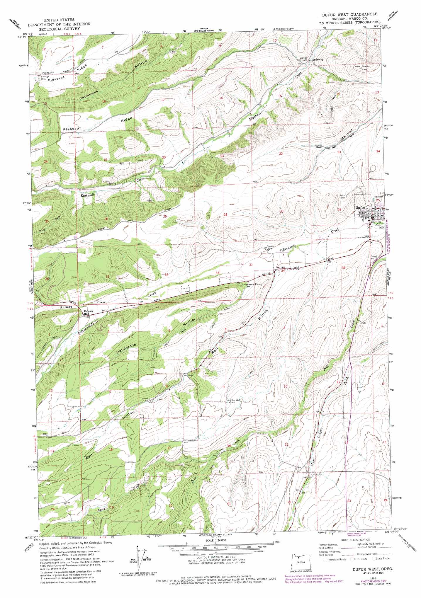
Dufur West Topo Map Oregon
To zoom in, hover over the map of Dufur West
USGS Topo Quad 45121d2 - 1:24,000 scale
| Topo Map Name: | Dufur West |
| USGS Topo Quad ID: | 45121d2 |
| Print Size: | ca. 21 1/4" wide x 27" high |
| Southeast Coordinates: | 45.375° N latitude / 121.125° W longitude |
| Map Center Coordinates: | 45.4375° N latitude / 121.1875° W longitude |
| U.S. State: | OR |
| Filename: | o45121d2.jpg |
| Download Map JPG Image: | Dufur West topo map 1:24,000 scale |
| Map Type: | Topographic |
| Topo Series: | 7.5´ |
| Map Scale: | 1:24,000 |
| Source of Map Images: | United States Geological Survey (USGS) |
| Alternate Map Versions: |
Dufur West OR 1962, updated 1964 Download PDF Buy paper map Dufur West OR 1962, updated 1984 Download PDF Buy paper map Dufur West OR 1962, updated 1987 Download PDF Buy paper map Dufur West OR 2011 Download PDF Buy paper map Dufur West OR 2014 Download PDF Buy paper map |
1:24,000 Topo Quads surrounding Dufur West
White Salmon |
Lyle |
The Dalles North |
Stacker Butte |
Wishram |
Ketchum Reservoir |
Brown Creek |
The Dalles South |
Petersburg |
Emerson |
Fivemile Butte |
Wolf Run |
Dufur West |
Dufur East |
Summit Ridge |
Flag Point |
Friend |
Postage Stamp Butte |
Sherars Bridge |
Sinamox |
Rock Creek Reservoir |
Wamic |
Tygh Valley |
Maupin |
Dead Dog Canyon |
> Back to 45121a1 at 1:100,000 scale
> Back to 45120a1 at 1:250,000 scale
> Back to U.S. Topo Maps home
Dufur West topo map: Gazetteer
Dufur West: Airports
Fargher Airfield elevation 437m 1433′Dufur West: Canals
Dufur Ditch elevation 426m 1397′Dufur West: Populated Places
Dufur elevation 409m 1341′Endersby elevation 297m 974′
Dufur West: Post Offices
Dufur Post Office elevation 409m 1341′Endersly Post Office (historical) elevation 297m 974′
Dufur West: Reservoirs
Chase Reservoir elevation 632m 2073′Dufur Orchards Reservoir elevation 592m 1942′
Dufur West: Streams
Larch Creek elevation 554m 1817′Ramsey Creek elevation 464m 1522′
Wolf Run elevation 384m 1259′
Dufur West: Valleys
Henderson Hollow elevation 438m 1437′Lauronzon Canyon elevation 380m 1246′
Pine Hollow elevation 369m 1210′
Rail Hollow elevation 433m 1420′
Dufur West: Wells
Le Duc Well elevation 597m 1958′Dufur West digital topo map on disk
Buy this Dufur West topo map showing relief, roads, GPS coordinates and other geographical features, as a high-resolution digital map file on DVD: