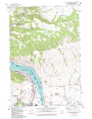
The Dalles North Topo Map Washington
To zoom in, hover over the map of The Dalles North
USGS Topo Quad 45121f2 - 1:24,000 scale
| Topo Map Name: | The Dalles North |
| USGS Topo Quad ID: | 45121f2 |
| Print Size: | ca. 21 1/4" wide x 27" high |
| Southeast Coordinates: | 45.625° N latitude / 121.125° W longitude |
| Map Center Coordinates: | 45.6875° N latitude / 121.1875° W longitude |
| U.S. States: | WA, OR |
| Filename: | o45121f2.jpg |
| Download Map JPG Image: | The Dalles North topo map 1:24,000 scale |
| Map Type: | Topographic |
| Topo Series: | 7.5´ |
| Map Scale: | 1:24,000 |
| Source of Map Images: | United States Geological Survey (USGS) |
| Alternate Map Versions: |
The Dalles North OR 1974, updated 1977 Download PDF Buy paper map The Dalles North OR 1974, updated 1977 Download PDF Buy paper map The Dalles North OR 1975, updated 1980 Download PDF Buy paper map The Dalles North OR 1994, updated 1995 Download PDF Buy paper map The Dalles North OR 2011 Download PDF Buy paper map The Dalles North OR 2014 Download PDF Buy paper map |
| FStopo: | US Forest Service topo The Dalles North is available: Download FStopo PDF Download FStopo TIF |
1:24,000 Topo Quads surrounding The Dalles North
> Back to 45121e1 at 1:100,000 scale
> Back to 45120a1 at 1:250,000 scale
> Back to U.S. Topo Maps home
The Dalles North topo map: Gazetteer
The Dalles North: Areas
Devils Hole elevation 281m 921′The Dalles North: Capes
Crates Point elevation 395m 1295′Klindt Point elevation 24m 78′
Squally Point elevation 27m 88′
The Dalles North: Cliffs
Windy Point elevation 319m 1046′The Dalles North: Flats
Chenoweth Flat elevation 39m 127′The Dalles North: Gaps
Rowena Gap elevation 24m 78′Rowena Gap elevation 24m 78′
The Dalles North: Islands
Rocky Island elevation 27m 88′Squaw Islands elevation 26m 85′
The Dalles North: Lakes
Little Spearfish Lake elevation 53m 173′Spearfish Lake elevation 59m 193′
Taylor Lake elevation 24m 78′
Tooley Lake elevation 25m 82′
The Dalles North: Populated Places
Chenoweth elevation 135m 442′Murdock elevation 105m 344′
Smithville elevation 126m 413′
The Dalles North: Reservoirs
Foley Lakes Reservoir elevation 97m 318′The Dalles North: Springs
Alder Spring elevation 278m 912′Cold Spring elevation 272m 892′
Frantz Spring elevation 62m 203′
Gooseberry Spring elevation 41m 134′
Marsh Spring elevation 100m 328′
Rowland Spring elevation 502m 1646′
Stanley Spring elevation 739m 2424′
Taylor Spring elevation 39m 127′
Thornton Spring elevation 118m 387′
The Dalles North: Streams
Badger Creek elevation 80m 262′Chenoweth Creek elevation 24m 78′
Gooseberry Creek elevation 28m 91′
Threemile Creek elevation 61m 200′
The Dalles North: Valleys
Columbia Gorge elevation 24m 78′Dillacort Canyon elevation 85m 278′
Green Canyon elevation 151m 495′
Hidden Valley elevation 38m 124′
Knight Canyon elevation 62m 203′
Stanley Canyon elevation 230m 754′
The Dalles North digital topo map on disk
Buy this The Dalles North topo map showing relief, roads, GPS coordinates and other geographical features, as a high-resolution digital map file on DVD:


