Lyle Topo Map Oregon
To zoom in, hover over the map of Lyle
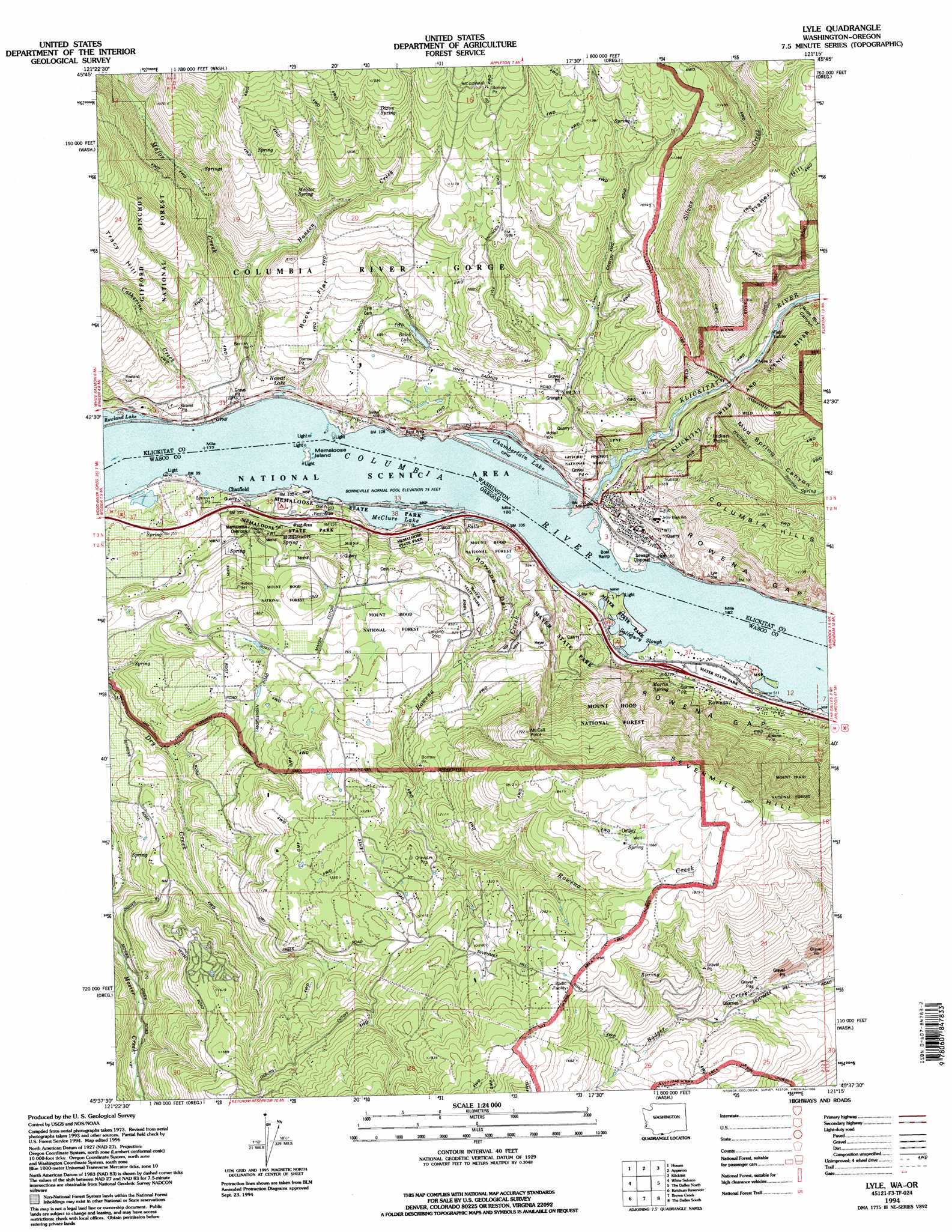
USGS Topo Quad 45121f3 - 1:24,000 scale
| Topo Map Name: | Lyle |
| USGS Topo Quad ID: | 45121f3 |
| Print Size: | ca. 21 1/4" wide x 27" high |
| Southeast Coordinates: | 45.625° N latitude / 121.25° W longitude |
| Map Center Coordinates: | 45.6875° N latitude / 121.3125° W longitude |
| U.S. States: | OR, WA |
| Filename: | o45121f3.jpg |
| Download Map JPG Image: | Lyle topo map 1:24,000 scale |
| Map Type: | Topographic |
| Topo Series: | 7.5´ |
| Map Scale: | 1:24,000 |
| Source of Map Images: | United States Geological Survey (USGS) |
| Alternate Map Versions: |
Lyle WA 1975, updated 1979 Download PDF Buy paper map Lyle WA 1978, updated 1978 Download PDF Buy paper map Lyle WA 1978, updated 1991 Download PDF Buy paper map Lyle WA 1994, updated 1996 Download PDF Buy paper map Lyle WA 2011 Download PDF Buy paper map Lyle WA 2014 Download PDF Buy paper map |
| FStopo: | US Forest Service topo Lyle is available: Download FStopo PDF Download FStopo TIF |
1:24,000 Topo Quads surrounding Lyle
Guler Mountain |
Quigley Butte |
Camas Prairie |
Dead Canyon |
Grayback Mountain |
Northwestern Lake |
Husum |
Appleton |
Klickitat |
Wahkiacus |
Hood River |
White Salmon |
Lyle |
The Dalles North |
Stacker Butte |
Parkdale |
Ketchum Reservoir |
Brown Creek |
The Dalles South |
Petersburg |
Dog River |
Fivemile Butte |
Wolf Run |
Dufur West |
Dufur East |
> Back to 45121e1 at 1:100,000 scale
> Back to 45120a1 at 1:250,000 scale
> Back to U.S. Topo Maps home
Lyle topo map: Gazetteer
Lyle: Airports
Rowena Dell Airstrip elevation 347m 1138′Lyle: Bays
Salisbury Slough elevation 24m 78′Lyle: Capes
Indian Point elevation 321m 1053′Lyle: Cliffs
Rowena Crest elevation 212m 695′Lyle: Flats
Rocky Flat elevation 185m 606′Lyle: Islands
Memaloose Island (historical) elevation 24m 78′Lyle: Lakes
Balch Lake elevation 182m 597′Chamberlain Lake elevation 24m 78′
Hewett Lake elevation 24m 78′
McClure Lake elevation 24m 78′
Lyle: Parks
Mayer State Park elevation 30m 98′Memaloose State Park elevation 40m 131′
Lyle: Populated Places
Lyle elevation 60m 196′Ortley elevation 556m 1824′
Rowena elevation 42m 137′
Lyle: Post Offices
Ortley Post Office (historical) elevation 556m 1824′Rowena Post Office (historical) elevation 42m 137′
Lyle: Ridges
Sevenmile Hill elevation 625m 2050′Lyle: Springs
Dixon Spring elevation 416m 1364′Martin Spring elevation 68m 223′
Middleswart Spring elevation 106m 347′
Molitor Spring elevation 264m 866′
Wetland Spring elevation 206m 675′
Lyle: Streams
Catherine Creek elevation 25m 82′Hanson Creek elevation 88m 288′
Klickitat River elevation 23m 75′
Major Creek elevation 27m 88′
Rowena Creek elevation 25m 82′
Silvas Creek elevation 39m 127′
Lyle: Summits
Chatfield Hill elevation 282m 925′Marsh Hill elevation 249m 816′
McCall Point elevation 524m 1719′
McClure Hill elevation 275m 902′
Lyle: Tunnels
Tunnel on WA 14 elevation 65m 213′Lyle: Valleys
Mud Spring Canyon elevation 56m 183′Rowena Dell elevation 34m 111′
Wide Sky Canyon elevation 56m 183′
Lyle digital topo map on disk
Buy this Lyle topo map showing relief, roads, GPS coordinates and other geographical features, as a high-resolution digital map file on DVD: