Little Huckleberry Mountain Topo Map Washington
To zoom in, hover over the map of Little Huckleberry Mountain
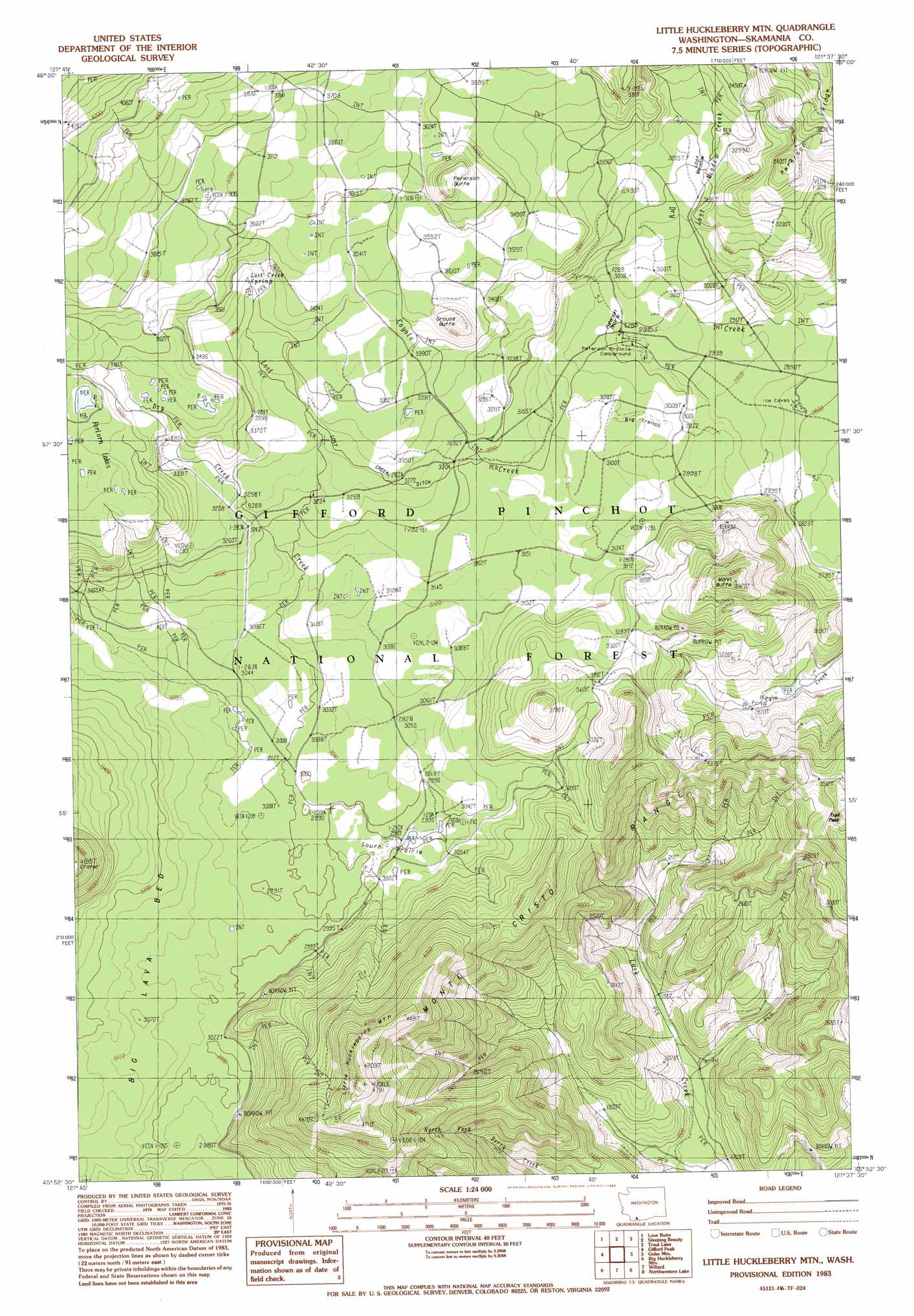
USGS Topo Quad 45121h6 - 1:24,000 scale
| Topo Map Name: | Little Huckleberry Mountain |
| USGS Topo Quad ID: | 45121h6 |
| Print Size: | ca. 21 1/4" wide x 27" high |
| Southeast Coordinates: | 45.875° N latitude / 121.625° W longitude |
| Map Center Coordinates: | 45.9375° N latitude / 121.6875° W longitude |
| U.S. State: | WA |
| Filename: | o45121h6.jpg |
| Download Map JPG Image: | Little Huckleberry Mountain topo map 1:24,000 scale |
| Map Type: | Topographic |
| Topo Series: | 7.5´ |
| Map Scale: | 1:24,000 |
| Source of Map Images: | United States Geological Survey (USGS) |
| Alternate Map Versions: |
Little Huckleberry Mtn WA 1983, updated 1983 Download PDF Buy paper map Little Huckleberry Mountain WA 1998, updated 2003 Download PDF Buy paper map Little Huckleberry Mountain WA 2011 Download PDF Buy paper map Little Huckleberry Mountain WA 2014 Download PDF Buy paper map |
| FStopo: | US Forest Service topo Little Huckleberry Mountain is available: Download FStopo PDF Download FStopo TIF |
1:24,000 Topo Quads surrounding Little Huckleberry Mountain
Spencer Butte |
Quartz Creek Butte |
Steamboat Mountain |
Mount Adams West |
Mount Adams East |
Burnt Peak |
Lone Butte |
Sleeping Beauty |
Trout Lake |
King Mountain |
Termination Point |
Gifford Peak |
Little Huckleberry Mountain |
Guler Mountain |
Quigley Butte |
Stabler |
Big Huckleberry Mountain |
Willard |
Northwestern Lake |
Husum |
Bonneville Dam |
Carson |
Mount Defiance |
Hood River |
White Salmon |
> Back to 45121e1 at 1:100,000 scale
> Back to 45120a1 at 1:250,000 scale
> Back to U.S. Topo Maps home
Little Huckleberry Mountain topo map: Gazetteer
Little Huckleberry Mountain: Basins
Big Trench elevation 936m 3070′Little Huckleberry Mountain: Canals
Lost Creek Ditch elevation 959m 3146′Little Huckleberry Mountain: Flats
South Prairie elevation 914m 2998′Little Huckleberry Mountain: Lakes
South Prairie Lake elevation 913m 2995′Little Huckleberry Mountain: Lavas
Big Lava Bed elevation 965m 3166′Little Huckleberry Mountain: Springs
Lost Creek Spring elevation 1049m 3441′Little Huckleberry Mountain: Streams
Coyote Creek elevation 893m 2929′Dry Creek elevation 956m 3136′
Lost Creek elevation 920m 3018′
Lost Meadow Creek elevation 886m 2906′
Little Huckleberry Mountain: Summits
Grouse Butte elevation 1152m 3779′Little Huckleberry Mountain elevation 1424m 4671′
Mann Butte elevation 1153m 3782′
Peterson Butte elevation 1188m 3897′
Little Huckleberry Mountain: Trails
Cougar Way elevation 1119m 3671′Little Huckleberry Trail elevation 1054m 3458′
Lusk Creek Trail elevation 1140m 3740′
Little Huckleberry Mountain digital topo map on disk
Buy this Little Huckleberry Mountain topo map showing relief, roads, GPS coordinates and other geographical features, as a high-resolution digital map file on DVD: