Damascus Topo Map Oregon
To zoom in, hover over the map of Damascus
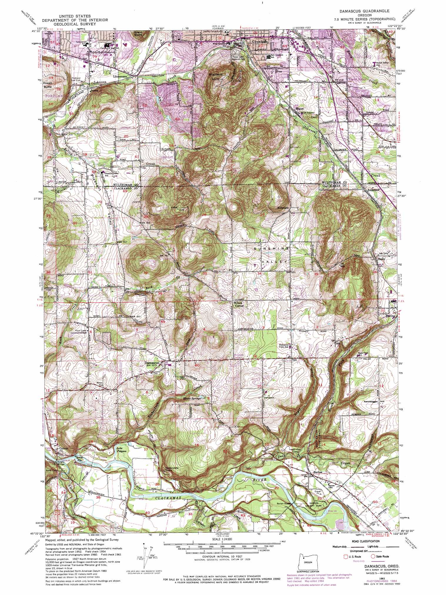
USGS Topo Quad 45122d4 - 1:24,000 scale
| Topo Map Name: | Damascus |
| USGS Topo Quad ID: | 45122d4 |
| Print Size: | ca. 21 1/4" wide x 27" high |
| Southeast Coordinates: | 45.375° N latitude / 122.375° W longitude |
| Map Center Coordinates: | 45.4375° N latitude / 122.4375° W longitude |
| U.S. State: | OR |
| Filename: | o45122d4.jpg |
| Download Map JPG Image: | Damascus topo map 1:24,000 scale |
| Map Type: | Topographic |
| Topo Series: | 7.5´ |
| Map Scale: | 1:24,000 |
| Source of Map Images: | United States Geological Survey (USGS) |
| Alternate Map Versions: |
Damascus OR 1954, updated 1956 Download PDF Buy paper map Damascus OR 1961, updated 1961 Download PDF Buy paper map Damascus OR 1961, updated 1972 Download PDF Buy paper map Damascus OR 1961, updated 1978 Download PDF Buy paper map Damascus OR 1961, updated 1985 Download PDF Buy paper map Damascus OR 1975, updated 1985 Download PDF Buy paper map Damascus OR 2011 Download PDF Buy paper map Damascus OR 2014 Download PDF Buy paper map |
1:24,000 Topo Quads surrounding Damascus
Vancouver |
Orchards |
Lacamas Creek |
Larch Mountain |
Bobs Mountain |
Portland |
Mount Tabor |
Camas |
Washougal |
Bridal Veil |
Lake Oswego |
Gladstone |
Damascus |
Sandy |
Bull Run |
Canby |
Oregon City |
Redland |
Estacada |
Cherryville |
Yoder |
Molalla |
Colton |
Elwood |
Bedford Point |
> Back to 45122a1 at 1:100,000 scale
> Back to 45122a1 at 1:250,000 scale
> Back to U.S. Topo Maps home
Damascus topo map: Gazetteer
Damascus: Airports
Trohs Memorial Airpark elevation 244m 800′Damascus: Basins
Sunshine Valley elevation 141m 462′Damascus: Bridges
Bakers Bridge elevation 24m 78′Barton Bridge elevation 46m 150′
Damascus: Lakes
Lake Pidgeon elevation 34m 111′Damascus: Mines
Hardscrabble Quarry elevation 66m 216′Damascus: Parks
Barton County Park elevation 67m 219′Bella Vista Park elevation 125m 410′
Boring-Estacada Rail Line elevation 81m 265′
Butler Creek Park elevation 119m 390′
Clackamas River Scenic Waterway elevation 31m 101′
Deep Creek County Park elevation 69m 226′
East Gresham Park elevation 92m 301′
Gradin Community Sports Park elevation 122m 400′
Hollybrook Park elevation 86m 282′
Jenne Butte Park elevation 163m 534′
Kane Road Park elevation 148m 485′
Main City Park elevation 90m 295′
Maple Park elevation 108m 354′
Pidgeon Park elevation 32m 104′
Powell Butte Nature Park elevation 75m 246′
Southeast Community Park elevation 146m 479′
Southeast Neighborhood Park elevation 144m 472′
Southwest Community Park elevation 82m 269′
Springwater Trail elevation 84m 275′
Thom Park elevation 110m 360′
Wilsada Park elevation 62m 203′
Damascus: Populated Places
Barton elevation 81m 265′Carver elevation 41m 134′
Damascus elevation 163m 534′
Damascus Heights elevation 182m 597′
Deep Creek (historical) elevation 83m 272′
Gresham elevation 97m 318′
Hillsview elevation 168m 551′
Powell Valley elevation 139m 456′
Damascus: Post Offices
Barton Post Office (historical) elevation 81m 265′Camp Ground Post Office (historical) elevation 121m 396′
Carver Post Office (historical) elevation 41m 134′
Clackemas Post Office (historical) elevation 42m 137′
Cushing Post Office (historical) elevation 57m 187′
Damascus Post Office (historical) elevation 163m 534′
Gresham Post Office elevation 91m 298′
Powell Valley Post Office (historical) elevation 139m 456′
Stone Post Office (historical) elevation 24m 78′
Damascus: Reservoirs
Binford Reservoir elevation 95m 311′Butler Creek Reservoir elevation 115m 377′
Connors Ponds elevation 157m 515′
McIntyre Reservoir elevation 64m 209′
Van Zyl Reservoir elevation 106m 347′
Damascus: Springs
Elliott Springs elevation 139m 456′Rays Spring elevation 262m 859′
Damascus: Streams
Butler Creek elevation 83m 272′Clear Creek elevation 25m 82′
Deep Creek elevation 43m 141′
Foster Creek elevation 44m 144′
Hattin Creek elevation 74m 242′
Kelley Creek elevation 73m 239′
Mitchell Creek elevation 95m 311′
North Fork Deep Creek elevation 59m 193′
North Fork Johnson Creek elevation 118m 387′
Noyer Creek elevation 56m 183′
Richardson Creek elevation 31m 101′
Damascus: Summits
Aemisegger Hill elevation 187m 613′Gresham Butte elevation 257m 843′
Damascus: Valleys
Pleasant Valley elevation 98m 321′Powell Valley elevation 107m 351′
Damascus digital topo map on disk
Buy this Damascus topo map showing relief, roads, GPS coordinates and other geographical features, as a high-resolution digital map file on DVD: