Gladstone Topo Map Oregon
To zoom in, hover over the map of Gladstone
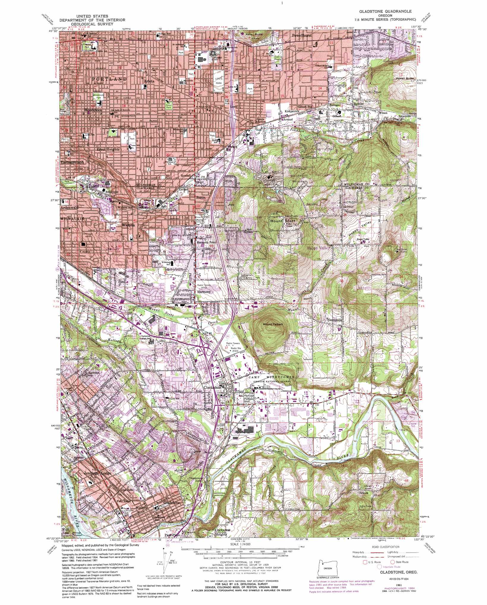
USGS Topo Quad 45122d5 - 1:24,000 scale
| Topo Map Name: | Gladstone |
| USGS Topo Quad ID: | 45122d5 |
| Print Size: | ca. 21 1/4" wide x 27" high |
| Southeast Coordinates: | 45.375° N latitude / 122.5° W longitude |
| Map Center Coordinates: | 45.4375° N latitude / 122.5625° W longitude |
| U.S. State: | OR |
| Filename: | o45122d5.jpg |
| Download Map JPG Image: | Gladstone topo map 1:24,000 scale |
| Map Type: | Topographic |
| Topo Series: | 7.5´ |
| Map Scale: | 1:24,000 |
| Source of Map Images: | United States Geological Survey (USGS) |
| Alternate Map Versions: |
Gladstone OR 1954, updated 1956 Download PDF Buy paper map Gladstone OR 1961, updated 1962 Download PDF Buy paper map Gladstone OR 1961, updated 1972 Download PDF Buy paper map Gladstone OR 1961, updated 1977 Download PDF Buy paper map Gladstone OR 1961, updated 1985 Download PDF Buy paper map Gladstone OR 1961, updated 1991 Download PDF Buy paper map Gladstone OR 1975, updated 1977 Download PDF Buy paper map Gladstone OR 2011 Download PDF Buy paper map Gladstone OR 2014 Download PDF Buy paper map |
1:24,000 Topo Quads surrounding Gladstone
Sauvie Island |
Vancouver |
Orchards |
Lacamas Creek |
Larch Mountain |
Linnton |
Portland |
Mount Tabor |
Camas |
Washougal |
Beaverton |
Lake Oswego |
Gladstone |
Damascus |
Sandy |
Sherwood |
Canby |
Oregon City |
Redland |
Estacada |
Woodburn |
Yoder |
Molalla |
Colton |
Elwood |
> Back to 45122a1 at 1:100,000 scale
> Back to 45122a1 at 1:250,000 scale
> Back to U.S. Topo Maps home
Gladstone topo map: Gazetteer
Gladstone: Airports
Cub Airport elevation 187m 613′Mason Airstrip elevation 5m 16′
Oak Hill Airstrip elevation 64m 209′
Gladstone: Crossings
Interchange 11 elevation 24m 78′Interchange 12A elevation 49m 160′
Interchange 12B elevation 49m 160′
Interchange 13 elevation 44m 144′
Interchange 14 elevation 65m 213′
Interchange 16 elevation 73m 239′
Interchange 17 elevation 65m 213′
Interchange 19 elevation 84m 275′
Gladstone: Dams
Veterans Dam elevation 200m 656′Gladstone: Islands
Beebe Island elevation 17m 55′Gladstone: Parks
Alma Myra Park elevation 48m 157′Altamont Park elevation 193m 633′
Ann-Toni Schreiber Park elevation 33m 108′
Ashley Meadows Park elevation 103m 337′
Beggars Tick Wildlife Refuge elevation 64m 209′
Berkeley City Park elevation 46m 150′
Bloomington City Park elevation 73m 239′
Brentwood City Park elevation 79m 259′
Brentwood Park elevation 79m 259′
Brookside Park elevation 66m 216′
Carver County Boat Ramp elevation 23m 75′
Charles Ames Memorial City Park elevation 13m 42′
Clatsop Butte City Park elevation 175m 574′
Creston City Park elevation 64m 209′
Cross Memorial City Park elevation 9m 29′
Dierickx Field elevation 20m 65′
Earl Boyles City Park elevation 80m 262′
Eastridge City Park elevation 235m 770′
Ed Benedict City Park elevation 87m 285′
Errol Heights City Park elevation 45m 147′
Essex City Park elevation 72m 236′
Firland Parkway elevation 70m 229′
Flavel City Park elevation 72m 236′
Furnberg Park elevation 54m 177′
Gates Park Property elevation 65m 213′
Gentemann Property elevation 138m 452′
Gilbert Heights City Park elevation 71m 232′
Gilbert Primary Park elevation 87m 285′
Glen Echo Wetlands elevation 23m 75′
Glenwood City Park elevation 66m 216′
Happy Valley City Park elevation 156m 511′
Happy Valley Nature Park elevation 185m 606′
Harmony Road Neighborhood Park elevation 25m 82′
Harney City Park elevation 74m 242′
Heddie Notz Park elevation 49m 160′
High Rocks City Park elevation 11m 36′
Johnson City Park elevation 52m 170′
Kelly Butte Natural Area elevation 180m 590′
Kern City Park elevation 70m 229′
Kingsley D Bundy City Park elevation 82m 269′
Laurelwood City Park elevation 71m 232′
Leach Botanical Garden elevation 68m 223′
Lents City Park elevation 79m 259′
Lewelling Elementary School Tennis Courts elevation 53m 173′
Lower Powell Butte Floodplain elevation 74m 242′
Max Patterson Memorial City Park elevation 21m 68′
Meldrum Bar City Park elevation 7m 22′
Mill Park elevation 43m 141′
Minthorn North Natural Area elevation 27m 88′
Mount Scott City Park elevation 72m 236′
Mount Talbert Nature Park elevation 198m 649′
North Clackamas Aquatic Park elevation 44m 144′
North Clackamas Central Park elevation 19m 62′
Olson Wetlands elevation 19m 62′
PTC/Abernethy Lane Trail elevation 28m 91′
Raymond City Park elevation 65m 213′
Ridgegate City Park elevation 81m 265′
Riverside County Park elevation 19m 62′
Salty Acres Wetlands elevation 49m 160′
Sara Hite Rose Garden elevation 19m 62′
Sherwood Forest Tot Lot elevation 18m 59′
Sieben Park elevation 93m 305′
Southern Lites Park elevation 106m 347′
Springwater Corridor Trail elevation 63m 206′
Springwater on the Willamette elevation 67m 219′
Stocker City Park elevation 28m 91′
Summerfield Park elevation 136m 446′
Tenino Property elevation 78m 255′
Terrace Trails Park elevation 84m 275′
The Milwaukie Center elevation 19m 62′
Tideman Johnson City Park elevation 24m 78′
Valley View City Park elevation 99m 324′
Village Green Park elevation 92m 301′
Walker Stadium elevation 83m 272′
Water Tower Park elevation 56m 183′
Woodstock City Park elevation 75m 246′
Youth Adventure Park elevation 14m 45′
Gladstone: Populated Places
Arleta elevation 70m 229′Battin elevation 63m 206′
Clackamas elevation 49m 160′
Eastmoreland elevation 60m 196′
Errol Heights elevation 83m 272′
Gilbert elevation 87m 285′
Gladstone elevation 19m 62′
Glen Echo elevation 28m 91′
Happy Valley elevation 150m 492′
Harmony elevation 51m 167′
Harmony Point elevation 59m 193′
Jennings Lodge elevation 29m 95′
Johnson City elevation 34m 111′
Lents elevation 65m 213′
Oatfield elevation 109m 357′
Park Place elevation 21m 68′
Sunnyside elevation 113m 370′
Woodstock elevation 77m 252′
Gladstone: Post Offices
Arleta Post Office (historical) elevation 70m 229′Clackamas Post Office elevation 49m 160′
Creston Post Office elevation 61m 200′
Errol Post Office (historical) elevation 32m 104′
Gladstone Post Office elevation 19m 62′
Jennings Lodge Post Office (historical) elevation 29m 95′
Lents at Eastport Post Office elevation 73m 239′
Lents Post Office elevation 65m 213′
Park Place Post Office (historical) elevation 21m 68′
Payn Post Office (historical) elevation 65m 213′
Southgate Post Office (historical) elevation 64m 209′
Stanley Post Office (historical) elevation 41m 134′
Sunnyside Post Office (historical) elevation 113m 370′
Sycamore Post Office (historical) elevation 71m 232′
Tremont Post Office (historical) elevation 68m 223′
Woodstock Post Office (historical) elevation 77m 252′
Gladstone: Reservoirs
Chautauqua Lake (historical) elevation 39m 127′Johnson Lake elevation 33m 108′
Veterans Reservoir elevation 200m 656′
Gladstone: Springs
Lovawalla Spring elevation 33m 108′Gladstone: Streams
Alder Creek elevation 17m 55′Camas Creek elevation 18m 59′
Cow Creek elevation 13m 42′
Dean Creek elevation 29m 95′
Eda Creek elevation 11m 36′
Johnson Creek elevation 16m 52′
Lithgow Creek elevation 15m 49′
Mount Scott Creek elevation 16m 52′
Phillips Creek elevation 30m 98′
Rock Creek elevation 22m 72′
Scottie Creek elevation 132m 433′
Veterans Creek elevation 70m 229′
Gladstone: Summits
Kelly Butte elevation 170m 557′Mount Scott elevation 333m 1092′
Mount Talbert elevation 218m 715′
Oatfield Hill elevation 128m 419′
Powell Butte elevation 191m 626′
Scouter Mountain elevation 284m 931′
Gladstone: Valleys
Happy Valley elevation 133m 436′Gladstone digital topo map on disk
Buy this Gladstone topo map showing relief, roads, GPS coordinates and other geographical features, as a high-resolution digital map file on DVD: