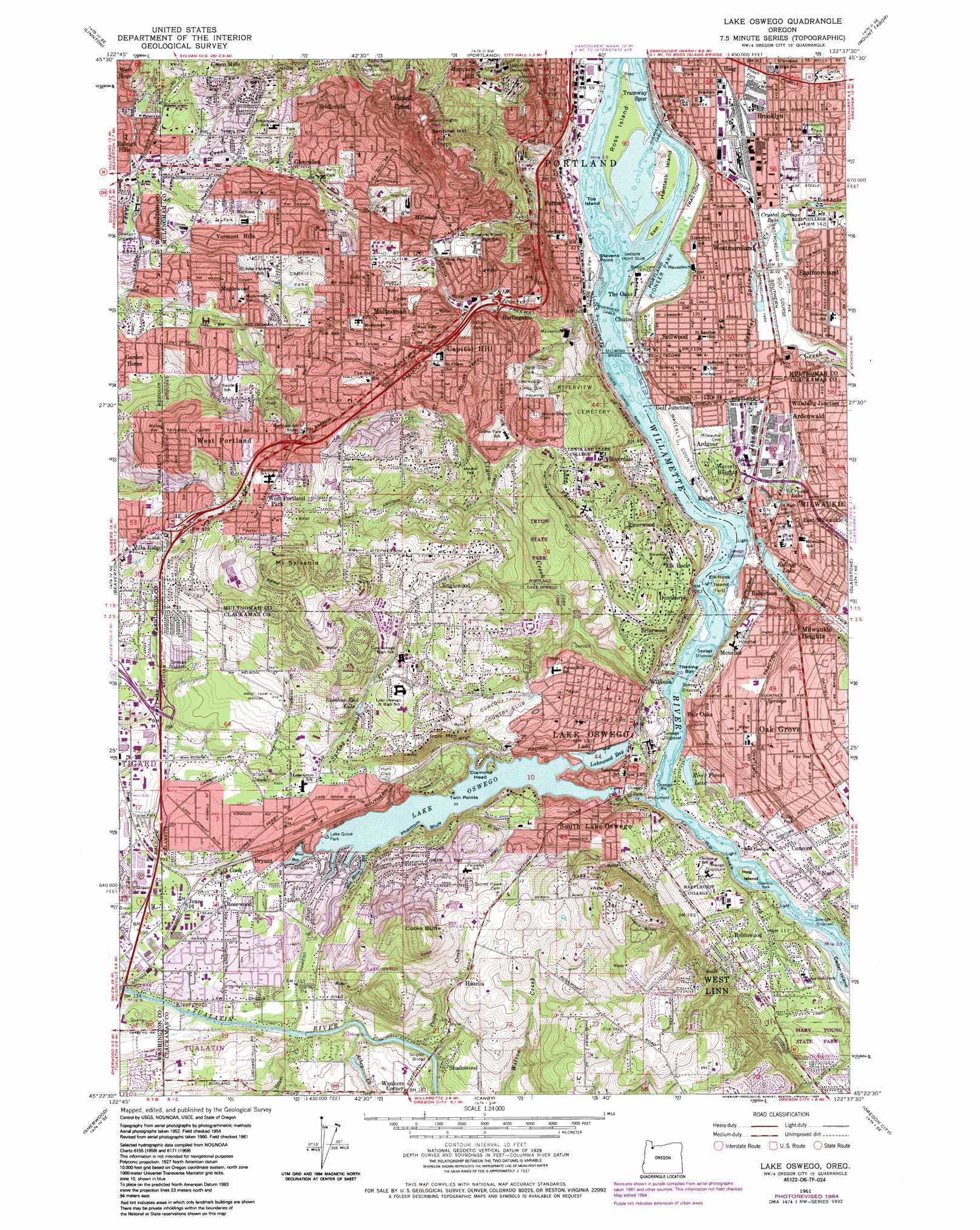
Lake Oswego Topo Map Oregon
To zoom in, hover over the map of Lake Oswego
USGS Topo Quad 45122d6 - 1:24,000 scale
| Topo Map Name: | Lake Oswego |
| USGS Topo Quad ID: | 45122d6 |
| Print Size: | ca. 21 1/4" wide x 27" high |
| Southeast Coordinates: | 45.375° N latitude / 122.625° W longitude |
| Map Center Coordinates: | 45.4375° N latitude / 122.6875° W longitude |
| U.S. State: | OR |
| Filename: | o45122d6.jpg |
| Download Map JPG Image: | Lake Oswego topo map 1:24,000 scale |
| Map Type: | Topographic |
| Topo Series: | 7.5´ |
| Map Scale: | 1:24,000 |
| Source of Map Images: | United States Geological Survey (USGS) |
| Alternate Map Versions: |
Oswego OR 1954, updated 1957 Download PDF Buy paper map Lake Oswego OR 1961, updated 1962 Download PDF Buy paper map Lake Oswego OR 1961, updated 1971 Download PDF Buy paper map Lake Oswego OR 1961, updated 1972 Download PDF Buy paper map Lake Oswego OR 1961, updated 1978 Download PDF Buy paper map Lake Oswego OR 1961, updated 1985 Download PDF Buy paper map Lake Oswego OR 2011 Download PDF Buy paper map Lake Oswego OR 2014 Download PDF Buy paper map |
1:24,000 Topo Quads surrounding Lake Oswego
Dixie Mountain |
Sauvie Island |
Vancouver |
Orchards |
Lacamas Creek |
Hillsboro |
Linnton |
Portland |
Mount Tabor |
Camas |
Scholls |
Beaverton |
Lake Oswego |
Gladstone |
Damascus |
Newberg |
Sherwood |
Canby |
Oregon City |
Redland |
Saint Paul |
Woodburn |
Yoder |
Molalla |
Colton |
> Back to 45122a1 at 1:100,000 scale
> Back to 45122a1 at 1:250,000 scale
> Back to U.S. Topo Maps home
Lake Oswego topo map: Gazetteer
Lake Oswego: Airports
Amart Farms Airstrip elevation 94m 308′Hanna Industries Airstrip elevation 16m 52′
Legacy Meridian Park Hospital Heliport elevation 64m 209′
Oregon Health Sciences University Heliport elevation 165m 541′
PGE Service Center Airstrip elevation 17m 55′
Port Arbour Seaplane Base (historical) elevation 16m 52′
Wileys Airstrip elevation 3m 9′
Lake Oswego: Bars
Oswego Rock elevation 15m 49′Thesing Bar elevation 3m 9′
Lake Oswego: Bays
Blue Heron Bay elevation 33m 108′Lakewood Bay elevation 31m 101′
West Bay elevation 31m 101′
Lake Oswego: Bridges
Sellwood Bridge elevation 3m 9′Shipley Bridge elevation 30m 98′
Lake Oswego: Canals
Oswego Canal elevation 32m 104′Lake Oswego: Capes
Cedar Island elevation 5m 16′Stevens Point elevation 3m 9′
Twin Points elevation 33m 108′
Lake Oswego: Cliffs
Phantom Bluff elevation 31m 101′Lake Oswego: Crossings
Interchange 290 elevation 57m 187′Interchange 291 elevation 68m 223′
Interchange 292A elevation 54m 177′
Interchange 292B elevation 93m 305′
Interchange 293 elevation 112m 367′
Interchange 294 elevation 129m 423′
Interchange 295 elevation 146m 479′
Interchange 296A elevation 138m 452′
Interchange 296B elevation 126m 413′
Interchange 297 elevation 110m 360′
Interchange 298 elevation 50m 164′
Milwaukie Interchange (historical) elevation 10m 32′
Lake Oswego: Dams
Lake Oswego Dam elevation 31m 101′Lake Oswego: Islands
Diamond Head elevation 42m 137′East Island elevation 3m 9′
Elk Rock Island elevation 12m 39′
Hardtack Island elevation 3m 9′
Hog Island elevation 9m 29′
Ross Island elevation 3m 9′
Toe Island elevation 3m 9′
Lake Oswego: Parks
Albert Kelly City Park elevation 117m 383′April Hill City Park elevation 83m 272′
Ardenwald Park elevation 47m 154′
Aspen City Park elevation 126m 413′
Benski Park elevation 193m 633′
Beth Ryan Nature Preserve elevation 52m 170′
Brooklyn City Park elevation 19m 62′
Brooklyn School Park elevation 19m 62′
Browns Ferry City Park elevation 34m 111′
Bryant Woods Nature Park elevation 46m 150′
Bunnell Park elevation 40m 131′
Burlingame City Park elevation 118m 387′
Butterfly City Park elevation 15m 49′
Campbell Native Gardens elevation 56m 183′
Canal Acres Nature Park elevation 37m 121′
Cedar Island Park elevation 9m 29′
Cedaroak Boat Ramp elevation 4m 13′
Century Park elevation 34m 111′
Cooks Butte City Park elevation 171m 561′
Cornell Natural Area elevation 119m 390′
Cottonwood Bay City Park elevation 3m 9′
Council Crest City Park elevation 289m 948′
Crystal Springs Rhododendron Garden elevation 20m 65′
Custer City Park elevation 149m 488′
Dewitt City Park elevation 170m 557′
Dickinson City Park elevation 123m 403′
Dickinson Woods elevation 145m 475′
Dogwood Park elevation 13m 42′
Eastmoreland Playground elevation 22m 72′
Elk Rock Island Natural Area elevation 4m 13′
Elk Rock Island Park elevation 12m 39′
Ellen R Burgess Nature Preserve elevation 43m 141′
Falcon Park elevation 131m 429′
Fanno Creek Natural Area elevation 101m 331′
Firlane Property elevation 136m 446′
Foothills City Park elevation 10m 32′
Freepons City Park elevation 105m 344′
Fulton City Park elevation 105m 344′
Gabriel City Park elevation 113m 370′
George Himes City Park elevation 146m 479′
George Rogers City Park elevation 4m 13′
Glenmorrie City Park elevation 78m 255′
Glenmorrie Greenway elevation 54m 177′
Gray Park elevation 145m 475′
Greentree City Park elevation 130m 426′
Hamilton City Park elevation 117m 383′
Healy Heights City Park elevation 289m 948′
Heritage Tree Park elevation 64m 209′
Hide-A-Way City Park elevation 55m 180′
Hideaway Park elevation 77m 252′
Hillsdale City Park elevation 133m 436′
Iron Mountain City Park elevation 99m 324′
Jefferson Street Boat Ramp elevation 5m 16′
Jensen Natural Area elevation 92m 301′
Johnson Creek City Park elevation 14m 45′
Kelly Creek Natural Area elevation 95m 311′
Kenilworth City Park elevation 41m 134′
Kerr Natural Area elevation 195m 639′
Kerr Site elevation 163m 534′
Lake Grove Park elevation 37m 121′
Lamont Springs City Park elevation 43m 141′
Lesser City Park elevation 156m 511′
Luscher Farm City Park elevation 140m 459′
Maricara Natural Area elevation 153m 501′
Mark Lane Tot Lot elevation 61m 200′
Marshall City Park elevation 92m 301′
McNary City Park elevation 241m 790′
Millenium Plaza City Park elevation 35m 114′
Moonshadow Park elevation 78m 255′
Nyberg Creek Greenway elevation 34m 111′
Oaks Bottom Wildlife Refuge elevation 8m 26′
Oswego Park elevation 29m 95′
Palamino Park elevation 187m 613′
Pendleton City Park elevation 100m 328′
Pennington City Park elevation 66m 216′
Peter Kerr Natural Area elevation 77m 252′
Pilkington City Park elevation 43m 141′
Pine Cone City Park elevation 103m 337′
Pioneer Park elevation 7m 22′
Portland Traction Trail elevation 26m 85′
Powell City Park elevation 22m 72′
Powers Marine Park elevation 3m 9′
Raleighwood Park elevation 80m 262′
Reed College Parkway elevation 39m 127′
Rhododendron Park elevation 133m 436′
Risley Park elevation 25m 82′
River Run City Park elevation 38m 124′
Rivergrove City Boat Ramp elevation 33m 108′
Rivergrove City Park elevation 38m 124′
Riverside Property elevation 3m 9′
Rivervilla Park elevation 10m 32′
Robinwood Park elevation 38m 124′
Roehr City Park elevation 8m 26′
Rossman City Park elevation 56m 183′
Rowe Middle School Tennis Courts elevation 18m 59′
Sam Jackson Park elevation 129m 423′
Sckavone Stadium elevation 18m 59′
Scott Park elevation 13m 42′
Sellwood City Park elevation 38m 124′
Sellwood Riverfront City Park elevation 3m 9′
Skate Park elevation 29m 95′
Skyline Ridge Park elevation 213m 698′
South Shore Natural Area elevation 91m 298′
Southwood City Park elevation 77m 252′
Spring Garden City Park elevation 150m 492′
Spring Park Natural Area elevation 7m 22′
Springbrook City Park elevation 118m 387′
Stephens Creek Natural Area elevation 126m 413′
Stoneridge City Park elevation 51m 167′
Sunburst Park elevation 214m 702′
Sunnyslope Open Space elevation 98m 321′
Sylvania City Park elevation 194m 636′
Terwilliger Boulevard Parkway elevation 119m 390′
Thomas City Park elevation 108m 354′
Toe Island City Park elevation 3m 9′
Tryon Creek State Park elevation 37m 121′
Waluga Park East elevation 77m 252′
Waluga Park West elevation 70m 229′
West Portland Park Natural Area elevation 192m 629′
Westlake City Park elevation 98m 321′
Westmoreland City Park elevation 18m 59′
Westridge City Park elevation 74m 242′
Willamette Park & Boat Ramp elevation 4m 13′
Woodmont City Park elevation 120m 393′
Woods Memorial Natural Area elevation 138m 452′
Lake Oswego: Pillars
Copeleys Rock elevation 3m 9′Lake Oswego: Populated Places
Ardenwald elevation 47m 154′Bertha (historical) elevation 144m 472′
Briarwood elevation 62m 203′
Bridlemile elevation 196m 643′
Brooklyn elevation 28m 91′
Bryant elevation 37m 121′
Burlingame elevation 111m 364′
Capitol Hill elevation 144m 472′
Carson Heights elevation 154m 505′
Christie (historical) elevation 3m 9′
Concord elevation 25m 82′
Cook elevation 47m 154′
Dunthorpe elevation 82m 269′
Englewood elevation 145m 475′
Fair Oaks elevation 41m 134′
Fulton (historical) elevation 16m 52′
Glencullen elevation 96m 314′
Hillsdale elevation 183m 600′
Jean elevation 51m 167′
Johns Landing elevation 169m 554′
Kellogg Park elevation 16m 52′
Lake Grove (historical) elevation 31m 101′
Lake Oswego elevation 55m 180′
Lakewood elevation 47m 154′
Maplewood elevation 118m 387′
Marquam Hill elevation 175m 574′
Marylhurst elevation 46m 150′
Milwaukie elevation 13m 42′
Milwaukie Heights elevation 43m 141′
Multnomah elevation 154m 505′
Oak Grove elevation 55m 180′
Riverdale elevation 35m 114′
Rivergrove elevation 48m 157′
Riverwood elevation 133m 436′
Robinwood elevation 53m 173′
Rosewood elevation 47m 154′
Sellwood elevation 35m 114′
Shadowood elevation 58m 190′
South Lake Oswego elevation 73m 239′
South Portland (historical) elevation 88m 288′
Vermont Hills elevation 102m 334′
Villa Ridge elevation 126m 413′
Waverly Heights elevation 40m 131′
West Portland elevation 185m 606′
West Portland Park elevation 197m 646′
Westmoreland elevation 24m 78′
Lake Oswego: Post Offices
Ardenwald Post Office (historical) elevation 47m 154′Brockville Post Office (historical) elevation 34m 111′
Brooklyn Post Office elevation 28m 91′
Fulton Post Office (historical) elevation 16m 52′
Glencullen Post Office (historical) elevation 96m 314′
Hillsdale Post Office (historical) elevation 183m 600′
Lake Grove Post Office elevation 64m 209′
Lake Oswego Post Office elevation 56m 183′
Maplewood Post Office (historical) elevation 118m 387′
Marylhurst Post Office elevation 46m 150′
Milwaukie Post Office elevation 13m 42′
Mount Sylvania Post Office (historical) elevation 80m 262′
Multnomah Post Office elevation 154m 505′
Oak Grove Post Office elevation 55m 180′
Parkwood Post Office (historical) elevation 37m 121′
Sellwood Post Office elevation 26m 85′
Sellwood Post Office (historical) elevation 35m 114′
Sellwood-Moreland Post Office elevation 35m 114′
Shattuck Post Office (historical) elevation 83m 272′
West Portland Post Office (historical) elevation 185m 606′
Willsburgh Post Office (historical) elevation 21m 68′
Lake Oswego: Reservoirs
Crystal Lake elevation 16m 52′Crystal Springs Lake elevation 19m 62′
Kellogg Lake elevation 3m 9′
Lake Oswego elevation 25m 82′
Rainbow End Lake elevation 95m 311′
Reed Lake elevation 31m 101′
River Forest Lake elevation 7m 22′
Schaber Reservoir elevation 43m 141′
Lake Oswego: Ridges
Palatine Hill elevation 160m 524′Lake Oswego: Streams
Athey Creek elevation 30m 98′Boutwell Creek elevation 31m 101′
Bridlemile Creek elevation 91m 298′
Carter Creek elevation 55m 180′
Crystal Springs Creek elevation 13m 42′
Falling Creek elevation 115m 377′
Forest Creek elevation 3m 9′
Ivey Creek elevation 87m 285′
Johnson Creek elevation 5m 16′
Kellogg Creek elevation 3m 9′
Nyberg Creek elevation 33m 108′
Oswego Creek elevation 3m 9′
Paget Creek elevation 36m 118′
Pecan Creek elevation 31m 101′
Restoration Creek elevation 105m 344′
Saum Creek elevation 32m 104′
Shipley Creek elevation 55m 180′
Spring Brook Creek elevation 31m 101′
Spring Creek elevation 9m 29′
Tryon Creek elevation 3m 9′
Lake Oswego: Summits
Cooks Butte elevation 219m 718′Council Crest elevation 196m 643′
Iron Mountain elevation 154m 505′
Mount Sylvania elevation 294m 964′
Lake Oswego digital topo map on disk
Buy this Lake Oswego topo map showing relief, roads, GPS coordinates and other geographical features, as a high-resolution digital map file on DVD: