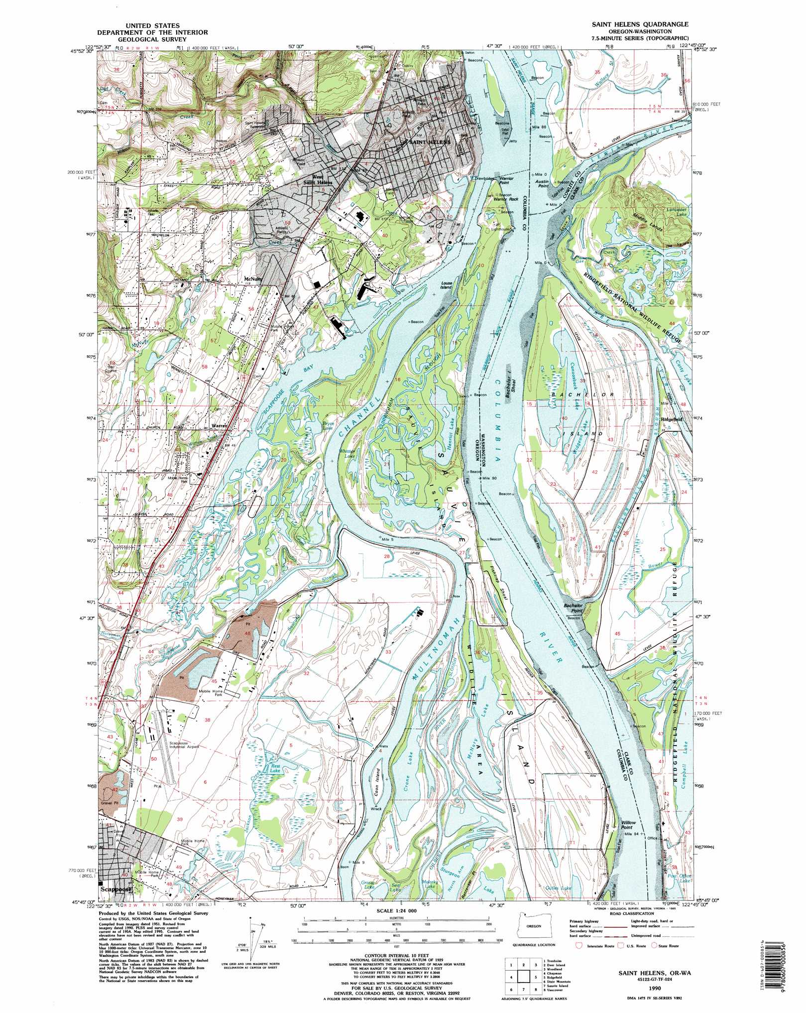
Saint Helens Topo Map Oregon
To zoom in, hover over the map of Saint Helens
USGS Topo Quad 45122g7 - 1:24,000 scale
| Topo Map Name: | Saint Helens |
| USGS Topo Quad ID: | 45122g7 |
| Print Size: | ca. 21 1/4" wide x 27" high |
| Southeast Coordinates: | 45.75° N latitude / 122.75° W longitude |
| Map Center Coordinates: | 45.8125° N latitude / 122.8125° W longitude |
| U.S. States: | OR, WA |
| Filename: | o45122g7.jpg |
| Download Map JPG Image: | Saint Helens topo map 1:24,000 scale |
| Map Type: | Topographic |
| Topo Series: | 7.5´ |
| Map Scale: | 1:24,000 |
| Source of Map Images: | United States Geological Survey (USGS) |
| Alternate Map Versions: |
St. Helens OR 1954, updated 1957 Download PDF Buy paper map St. Helens OR 1954, updated 1971 Download PDF Buy paper map St. Helens OR 1954, updated 1979 Download PDF Buy paper map Saint Helens OR 1990, updated 1995 Download PDF Buy paper map Saint Helens OR 2011 Download PDF Buy paper map Saint Helens OR 2014 Download PDF Buy paper map |
1:24,000 Topo Quads surrounding Saint Helens
Delena |
Rainier |
Kalama |
Woolford Creek |
Georges Peak |
Baker Point |
Trenholm |
Deer Island |
Woodland |
Ariel |
Bacona |
Chapman |
Saint Helens |
Ridgefield |
Battle Ground |
Meacham Corner |
Dixie Mountain |
Sauvie Island |
Vancouver |
Orchards |
Forest Grove |
Hillsboro |
Linnton |
Portland |
Mount Tabor |
> Back to 45122e1 at 1:100,000 scale
> Back to 45122a1 at 1:250,000 scale
> Back to U.S. Topo Maps home
Saint Helens topo map: Gazetteer
Saint Helens: Airports
Scappoose Industrial Airpark elevation 15m 49′Saint Helens: Bars
Bachelor Island Shoal elevation 3m 9′Fishtrap Shoal elevation 4m 13′
Henrici Bar (historical) elevation 3m 9′
Saint Helens Bar elevation 9m 29′
Saint Helens: Bays
North Arm elevation 3m 9′Scappoose Bay elevation 3m 9′
Saint Helens: Beaches
Lyons Beach elevation 4m 13′Saint Helens: Capes
Austin Point elevation 3m 9′Bachelor Point elevation 4m 13′
Cathlacom Point elevation 4m 13′
Rentenaar Point elevation 4m 13′
Warrior Point elevation 4m 13′
Willow Point elevation 4m 13′
Saint Helens: Channels
Duck Club Turn elevation 3m 9′Fales Channel elevation 3m 9′
Fales Channel elevation 3m 9′
Henrici Range elevation 3m 9′
Henrici Range elevation 3m 9′
Saint Helens Turn elevation 3m 9′
The Narrows elevation 3m 9′
Warrior Rock Range elevation 3m 9′
Saint Helens: Dams
Sauvie Island Dam elevation 5m 16′Saint Helens: Flats
Hathaway Lake elevation 4m 13′Salene Lake (historical) elevation 4m 13′
Saint Helens: Guts
Bachelor Island Slough elevation 3m 9′Bower Slough elevation 4m 13′
Crane Slough elevation 3m 9′
Cunningham Slough elevation 3m 9′
Petes Slough elevation 4m 13′
Saint Helens: Islands
Bachelor Island elevation 4m 13′Coon Island elevation 4m 13′
Louse Island elevation 4m 13′
Squaw Island elevation 3m 9′
Saint Helens: Lakes
Aarons Lake elevation 3m 9′Bryce Lake elevation 3m 9′
Campbell Lake elevation 3m 9′
Canvasback Lake elevation 3m 9′
Carty Lake elevation 3m 9′
Crane Lake elevation 3m 9′
Cunningham Lake elevation 3m 9′
Deep Lake elevation 2m 6′
Domeyer Lake elevation 3m 9′
Guiles Lake elevation 3m 9′
Henrici Lake elevation 3m 9′
Lily Pond elevation 4m 13′
Log Pond Lake elevation 3m 9′
Long Lake elevation 4m 13′
McCormick Lake elevation 3m 9′
McNary Lake elevation 3m 9′
Millionaire Lake elevation 4m 13′
Rays Lake elevation 3m 9′
Whittier Lake elevation 3m 9′
Widgeon Lake elevation 3m 9′
Widgeon Lake elevation 4m 13′
Saint Helens: Parks
Boise Cascade Park (historical) elevation 15m 49′Campbell Park elevation 38m 124′
Civic Pride Park elevation 27m 88′
Columbia Botanical Gardens elevation 22m 72′
Dalton City Park elevation 27m 88′
Gilbert River Boat Ramp elevation 3m 9′
Godfrey Park elevation 34m 111′
Heinie Heumann Park elevation 25m 82′
Highway 30 Greenway elevation 31m 101′
J J Collins Memorial Park elevation 4m 13′
Knighton Square elevation 21m 68′
Little League Park elevation 29m 95′
McCormick Park elevation 20m 65′
Ridgefield National Wildlife Refuge elevation 4m 13′
Riverfront Park elevation 10m 32′
Sand Island Marine Park elevation 6m 19′
Scappoose R V Park elevation 17m 55′
Walnut Tree City Park elevation 33m 108′
Saint Helens: Pillars
Warrior Rock elevation 10m 32′Saint Helens: Populated Places
Bachelor Flat (historical) elevation 79m 259′Cathlapotle (historical) elevation 7m 22′
Columbia Heights elevation 71m 232′
McNulty elevation 35m 114′
Saint Helens elevation 27m 88′
Warren elevation 15m 49′
West Saint Helens elevation 35m 114′
Saint Helens: Post Offices
High School Post Office (historical) elevation 34m 111′Saint Helens Post Office elevation 32m 104′
Saint Helens Station A Post Office (historical) elevation 32m 104′
Warren Post Office elevation 15m 49′
Saint Helens: Reservoirs
Petes Slough Reservoir elevation 5m 16′Rest Lake elevation 4m 13′
Saint Helens Reservoir elevation 81m 265′
Saint Helens: Streams
Crooked Creek elevation 4m 13′Dart Creek elevation 58m 190′
Evans Slough elevation 4m 13′
Frogmore Slough elevation 3m 9′
Gee Creek elevation 3m 9′
Gee Creek elevation 4m 13′
Gilbert River elevation 3m 9′
Honeyman Creek elevation 3m 9′
Jackson Creek elevation 4m 13′
Lake River elevation 3m 9′
Lewis River elevation 3m 9′
McNulty Creek elevation 3m 9′
Milton Creek elevation 3m 9′
North Fork McNulty Creek elevation 25m 82′
North Scappoose Creek elevation 9m 29′
Perry Creek elevation 50m 164′
Santosh Slough elevation 3m 9′
Scappoose Creek elevation 3m 9′
South Scappoose Creek elevation 9m 29′
Teal Creek elevation 3m 9′
Warren Creek elevation 3m 9′
Saint Helens: Summits
Nob Hill elevation 33m 108′Saint Helens: Valleys
Jackass Canyon elevation 27m 88′Saint Helens digital topo map on disk
Buy this Saint Helens topo map showing relief, roads, GPS coordinates and other geographical features, as a high-resolution digital map file on DVD: