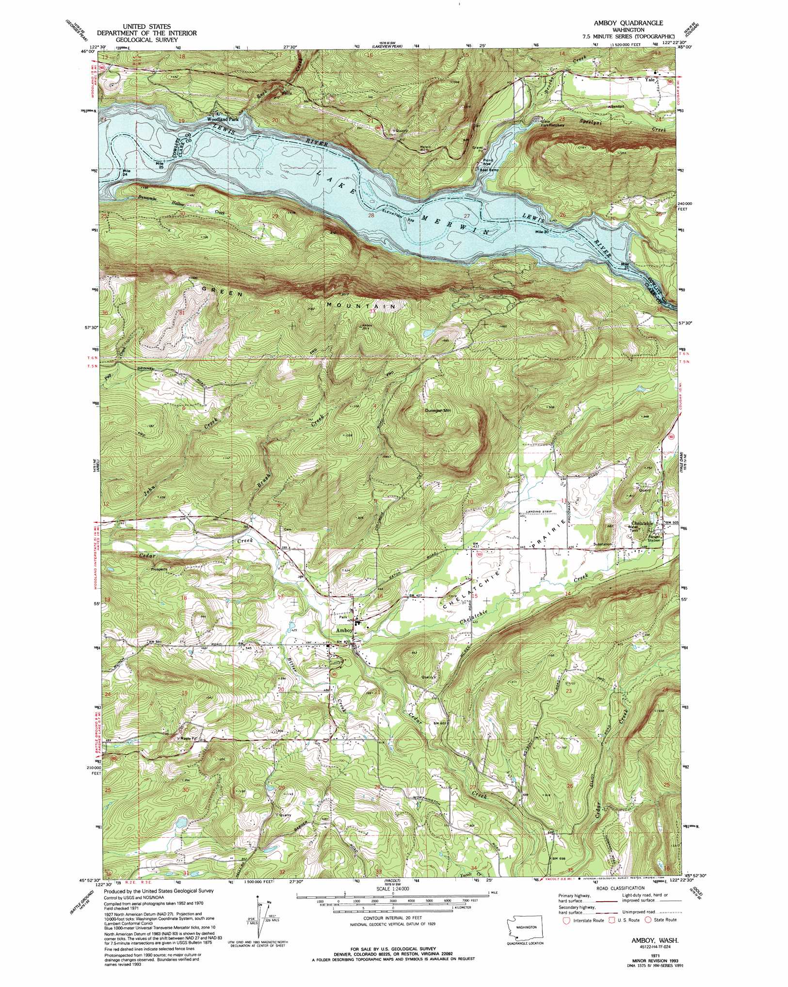
Amboy Topo Map Washington
To zoom in, hover over the map of Amboy
USGS Topo Quad 45122h4 - 1:24,000 scale
| Topo Map Name: | Amboy |
| USGS Topo Quad ID: | 45122h4 |
| Print Size: | ca. 21 1/4" wide x 27" high |
| Southeast Coordinates: | 45.875° N latitude / 122.375° W longitude |
| Map Center Coordinates: | 45.9375° N latitude / 122.4375° W longitude |
| U.S. State: | WA |
| Filename: | o45122h4.jpg |
| Download Map JPG Image: | Amboy topo map 1:24,000 scale |
| Map Type: | Topographic |
| Topo Series: | 7.5´ |
| Map Scale: | 1:24,000 |
| Source of Map Images: | United States Geological Survey (USGS) |
| Alternate Map Versions: |
Amboy WA 1971, updated 1973 Download PDF Buy paper map Amboy WA 1971, updated 1994 Download PDF Buy paper map Amboy WA 2011 Download PDF Buy paper map Amboy WA 2013 Download PDF Buy paper map |
1:24,000 Topo Quads surrounding Amboy
Hemlock Pass |
Wolf Point |
Elk Mountain |
Goat Mountain |
Mount Sainte Helens |
Woolford Creek |
Georges Peak |
Lakeview Peak |
Cougar |
Mount Mitchell |
Woodland |
Ariel |
Amboy |
Yale Dam |
Siouxon Peak |
Ridgefield |
Battle Ground |
Yacolt |
Dole |
Gumboot Mountain |
Vancouver |
Orchards |
Lacamas Creek |
Larch Mountain |
Bobs Mountain |
> Back to 45122e1 at 1:100,000 scale
> Back to 45122a1 at 1:250,000 scale
> Back to U.S. Topo Maps home
Amboy topo map: Gazetteer
Amboy: Airports
Mount Saint Helen's Aero Ranch Airport elevation 135m 442′Walter Sutton's Private Strip Airport elevation 138m 452′
Amboy: Dams
Fassett Reservoir Dam elevation 129m 423′Leroy Anderson Dam elevation 274m 898′
Seely Dam elevation 205m 672′
Amboy: Flats
Chelatchie Prairie elevation 135m 442′Amboy: Mines
Maple Pit elevation 258m 846′Amboy: Parks
Amboy Park elevation 127m 416′Speelyai Picnic Area elevation 74m 242′
Amboy: Populated Places
Amboy elevation 125m 410′Chelatchie elevation 155m 508′
Woodland Park elevation 79m 259′
Yale elevation 137m 449′
Amboy: Ranges
Green Mountain elevation 561m 1840′Amboy: Reservoirs
Columbia Tie Mill Pond elevation 445m 1459′Fassett Reservoir elevation 129m 423′
Leroy Anderson Reservoir elevation 274m 898′
Warren Seely Reservoir elevation 205m 672′
Amboy: Streams
Bitter Creek elevation 113m 370′Brooks Creek elevation 75m 246′
Brush Creek elevation 106m 347′
Buncombe Hollow Creek elevation 81m 265′
Chelatchie Creek elevation 122m 400′
John Creek elevation 99m 324′
Rock Creek elevation 74m 242′
Schmidt Creek elevation 91m 298′
Speelyai Creek elevation 74m 242′
Amboy: Summits
Dunegan Mountain elevation 539m 1768′Amboy digital topo map on disk
Buy this Amboy topo map showing relief, roads, GPS coordinates and other geographical features, as a high-resolution digital map file on DVD: