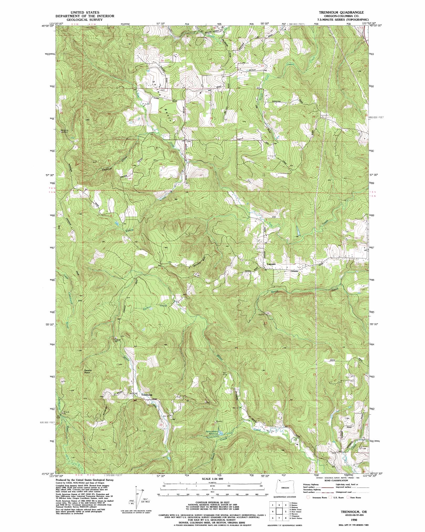
Trenholm Topo Map Oregon
To zoom in, hover over the map of Trenholm
USGS Topo Quad 45122h8 - 1:24,000 scale
| Topo Map Name: | Trenholm |
| USGS Topo Quad ID: | 45122h8 |
| Print Size: | ca. 21 1/4" wide x 27" high |
| Southeast Coordinates: | 45.875° N latitude / 122.875° W longitude |
| Map Center Coordinates: | 45.9375° N latitude / 122.9375° W longitude |
| U.S. State: | OR |
| Filename: | o45122h8.jpg |
| Download Map JPG Image: | Trenholm topo map 1:24,000 scale |
| Map Type: | Topographic |
| Topo Series: | 7.5´ |
| Map Scale: | 1:24,000 |
| Source of Map Images: | United States Geological Survey (USGS) |
| Alternate Map Versions: |
Trenholm OR 1971, updated 1974 Download PDF Buy paper map Trenholm OR 1971, updated 1985 Download PDF Buy paper map Trenholm OR 1990, updated 1995 Download PDF Buy paper map Trenholm OR 2011 Download PDF Buy paper map Trenholm OR 2014 Download PDF Buy paper map |
1:24,000 Topo Quads surrounding Trenholm
Oak Point |
Coal Creek |
Kelso |
Mount Brynion |
Hemlock Pass |
Clatskanie |
Delena |
Rainier |
Kalama |
Woolford Creek |
Pittsburg |
Baker Point |
Trenholm |
Deer Island |
Woodland |
Vernonia |
Bacona |
Chapman |
Saint Helens |
Ridgefield |
Buxton |
Meacham Corner |
Dixie Mountain |
Sauvie Island |
Vancouver |
> Back to 45122e1 at 1:100,000 scale
> Back to 45122a1 at 1:250,000 scale
> Back to U.S. Topo Maps home
Trenholm topo map: Gazetteer
Trenholm: Basins
Shiloh Basin elevation 127m 416′Trenholm: Parks
Royal Oaks City Park elevation 197m 646′Trenholm: Populated Places
Canaan elevation 119m 390′Trenholm elevation 264m 866′
Trenholm: Post Offices
Carico Post Office (historical) elevation 202m 662′Tidecreek Post Office (historical) elevation 126m 413′
Trenholm Post Office (historical) elevation 264m 866′
Valley Post Office (historical) elevation 308m 1010′
Trenholm: Reservoirs
Salmonberry Reservoir elevation 124m 406′Trenholm: Streams
Apilton Creek elevation 146m 479′Bishop Creek elevation 81m 265′
Endicott Creek elevation 96m 314′
Salmonberry Creek elevation 79m 259′
Smith Creek elevation 96m 314′
Trenholm: Summits
Serafin Point elevation 405m 1328′Trenholm digital topo map on disk
Buy this Trenholm topo map showing relief, roads, GPS coordinates and other geographical features, as a high-resolution digital map file on DVD: