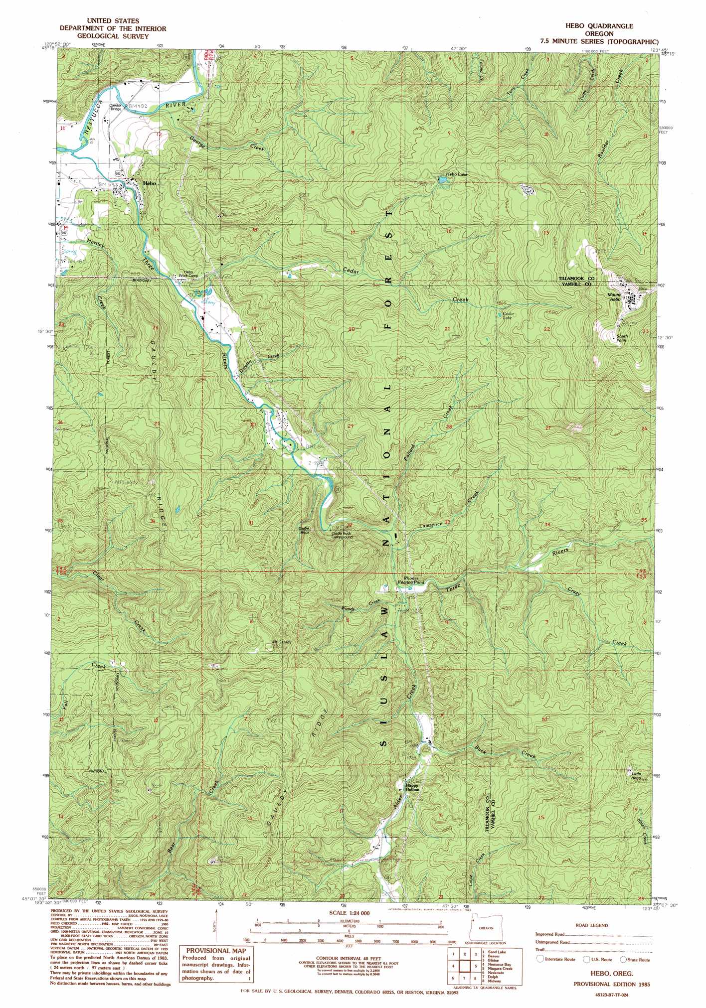
Hebo Topo Map Oregon
To zoom in, hover over the map of Hebo
USGS Topo Quad 45123b7 - 1:24,000 scale
| Topo Map Name: | Hebo |
| USGS Topo Quad ID: | 45123b7 |
| Print Size: | ca. 21 1/4" wide x 27" high |
| Southeast Coordinates: | 45.125° N latitude / 123.75° W longitude |
| Map Center Coordinates: | 45.1875° N latitude / 123.8125° W longitude |
| U.S. State: | OR |
| Filename: | o45123b7.jpg |
| Download Map JPG Image: | Hebo topo map 1:24,000 scale |
| Map Type: | Topographic |
| Topo Series: | 7.5´ |
| Map Scale: | 1:24,000 |
| Source of Map Images: | United States Geological Survey (USGS) |
| Alternate Map Versions: |
Hebo OR 1985, updated 1985 Download PDF Buy paper map Hebo OR 2011 Download PDF Buy paper map Hebo OR 2014 Download PDF Buy paper map |
| FStopo: | US Forest Service topo Hebo is available: Download FStopo PDF Download FStopo TIF |
1:24,000 Topo Quads surrounding Hebo
Netarts |
Tillamook |
The Peninsula |
Trask |
|
Sand Lake |
Beaver |
Blaine |
Dovre Peak |
|
Nestucca Bay |
Hebo |
Niagara Creek |
Springer Mountain |
|
Neskowin |
Dolph |
Midway |
Grand Ronde |
|
Lincoln City |
Devils Lake |
Stott Mountain |
Warnicke Creek |
Laurel Mountain |
> Back to 45123a1 at 1:100,000 scale
> Back to 45122a1 at 1:250,000 scale
> Back to U.S. Topo Maps home
Hebo topo map: Gazetteer
Hebo: Bridges
Condor Bridge elevation 12m 39′Hebo: Lakes
Cedar Lake elevation 524m 1719′Hebo: Populated Places
Happy Hollow elevation 165m 541′Hebo elevation 11m 36′
Hebo: Post Offices
Hebo Post Office elevation 11m 36′Hebo: Reservoirs
Hebo Lake elevation 513m 1683′Rhodes Rearing Pond elevation 102m 334′
Hebo: Ridges
Gauldy Ridge elevation 669m 2194′Hebo: Springs
Tucker Spring elevation 42m 137′Hebo: Streams
Alder Creek elevation 102m 334′Buck Creek elevation 139m 456′
Cedar Creek elevation 31m 101′
Crazy Creek elevation 144m 472′
Dorothy Creek elevation 47m 154′
George Creek elevation 12m 39′
Lawrence Creek elevation 94m 308′
Pollard Creek elevation 86m 282′
Rock Creek elevation 135m 442′
Spring Creek elevation 32m 104′
Woods Creek elevation 115m 377′
Hebo: Summits
Little Hebo elevation 692m 2270′Mount Gauldy elevation 660m 2165′
Mount Hebo elevation 957m 3139′
South Point elevation 955m 3133′
Hebo digital topo map on disk
Buy this Hebo topo map showing relief, roads, GPS coordinates and other geographical features, as a high-resolution digital map file on DVD: