Laurelwood Topo Map Oregon
To zoom in, hover over the map of Laurelwood
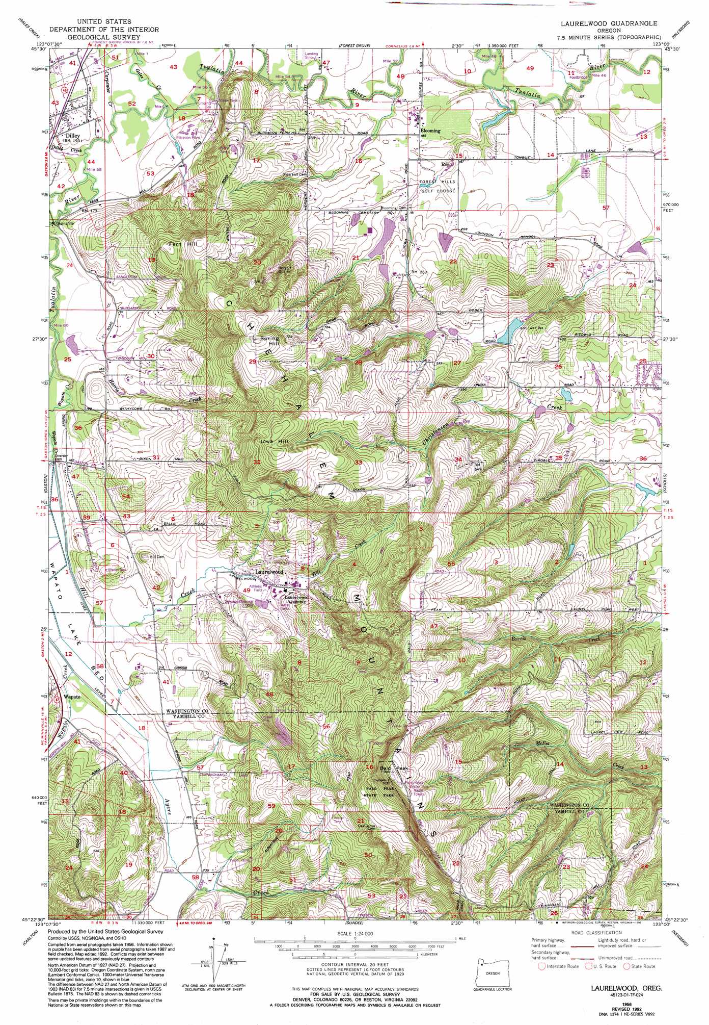
USGS Topo Quad 45123d1 - 1:24,000 scale
| Topo Map Name: | Laurelwood |
| USGS Topo Quad ID: | 45123d1 |
| Print Size: | ca. 21 1/4" wide x 27" high |
| Southeast Coordinates: | 45.375° N latitude / 123° W longitude |
| Map Center Coordinates: | 45.4375° N latitude / 123.0625° W longitude |
| U.S. State: | OR |
| Filename: | o45123d1.jpg |
| Download Map JPG Image: | Laurelwood topo map 1:24,000 scale |
| Map Type: | Topographic |
| Topo Series: | 7.5´ |
| Map Scale: | 1:24,000 |
| Source of Map Images: | United States Geological Survey (USGS) |
| Alternate Map Versions: |
Laurelwood OR 1956, updated 1958 Download PDF Buy paper map Laurelwood OR 1956, updated 1971 Download PDF Buy paper map Laurelwood OR 1956, updated 1992 Download PDF Buy paper map Laurelwood OR 2011 Download PDF Buy paper map Laurelwood OR 2014 Download PDF Buy paper map |
1:24,000 Topo Quads surrounding Laurelwood
Timber |
Buxton |
Meacham Corner |
Dixie Mountain |
Sauvie Island |
Roaring Creek |
Gales Creek |
Forest Grove |
Hillsboro |
Linnton |
Turner Creek |
Gaston |
Laurelwood |
Scholls |
Beaverton |
Fairdale |
Carlton |
Dundee |
Newberg |
Sherwood |
Muddy Valley |
Mcminnville |
Dayton |
Saint Paul |
Woodburn |
> Back to 45123a1 at 1:100,000 scale
> Back to 45122a1 at 1:250,000 scale
> Back to U.S. Topo Maps home
Laurelwood topo map: Gazetteer
Laurelwood: Dams
Dober Dam elevation 115m 377′Glenn Walters Dam elevation 50m 164′
Ken Larsen Dam elevation 121m 396′
Ornoname 16 Dam elevation 131m 429′
Pearson Dam elevation 136m 446′
Pierson Dam elevation 161m 528′
Unger Dam elevation 59m 193′
Laurelwood: Flats
Wapato Lake Bed elevation 55m 180′Laurelwood: Lakes
Meyers Pond elevation 42m 137′Laurelwood: Mines
Hergert Quarry elevation 136m 446′Laurel Quarry (historical) elevation 106m 347′
Laurelwood: Parks
Bald Peak State Park elevation 495m 1624′Halsey Memorial Park elevation 100m 328′
Halsey Veterans Memorial Park elevation 129m 423′
Laurelwood: Populated Places
Blooming elevation 58m 190′Dewey (historical) elevation 73m 239′
Dilley elevation 60m 196′
Laurelwood elevation 74m 242′
Laurelwood: Post Offices
Blooming Post Office (historical) elevation 58m 190′Dewey Post Office (historical) elevation 73m 239′
Dilley Post Office (historical) elevation 60m 196′
Roberts Post Office (historical) elevation 56m 183′
Wapata Post Office (historical) elevation 62m 203′
Laurelwood: Ranges
Chehalem Mountains elevation 404m 1325′Laurelwood: Reservoirs
Cook Reservoir elevation 191m 626′Dober Reservoir elevation 115m 377′
Guthrie Reservoir elevation 96m 314′
Hortons Reservoir elevation 257m 843′
Jesse Reservoir elevation 51m 167′
Koehnke Reservoir elevation 162m 531′
Larsen Reservoir elevation 121m 396′
Laurelwood Reservoir elevation 104m 341′
Nelson Pond elevation 59m 193′
North Reservoir elevation 56m 183′
Pearson Reservoir elevation 136m 446′
Pierson Reservoir elevation 161m 528′
S I C Reservoir elevation 50m 164′
South Reservoir elevation 62m 203′
Spangler Pond elevation 118m 387′
Unger Reservoir elevation 59m 193′
Walters Reservoir elevation 50m 164′
Weaver Reservoir elevation 249m 816′
Laurelwood: Streams
Ayers Creek elevation 54m 177′Carpenter Creek elevation 47m 154′
Dilley Creek elevation 48m 157′
Gales Creek elevation 47m 154′
Graver Creek elevation 188m 616′
Harris Creek elevation 50m 164′
South Fork Hill Creek elevation 68m 223′
Wapato Creek elevation 50m 164′
Laurelwood: Summits
Bald Peak elevation 498m 1633′Fern Hill elevation 202m 662′
Iowa Hill elevation 343m 1125′
Spring Hill elevation 307m 1007′
Laurelwood digital topo map on disk
Buy this Laurelwood topo map showing relief, roads, GPS coordinates and other geographical features, as a high-resolution digital map file on DVD: