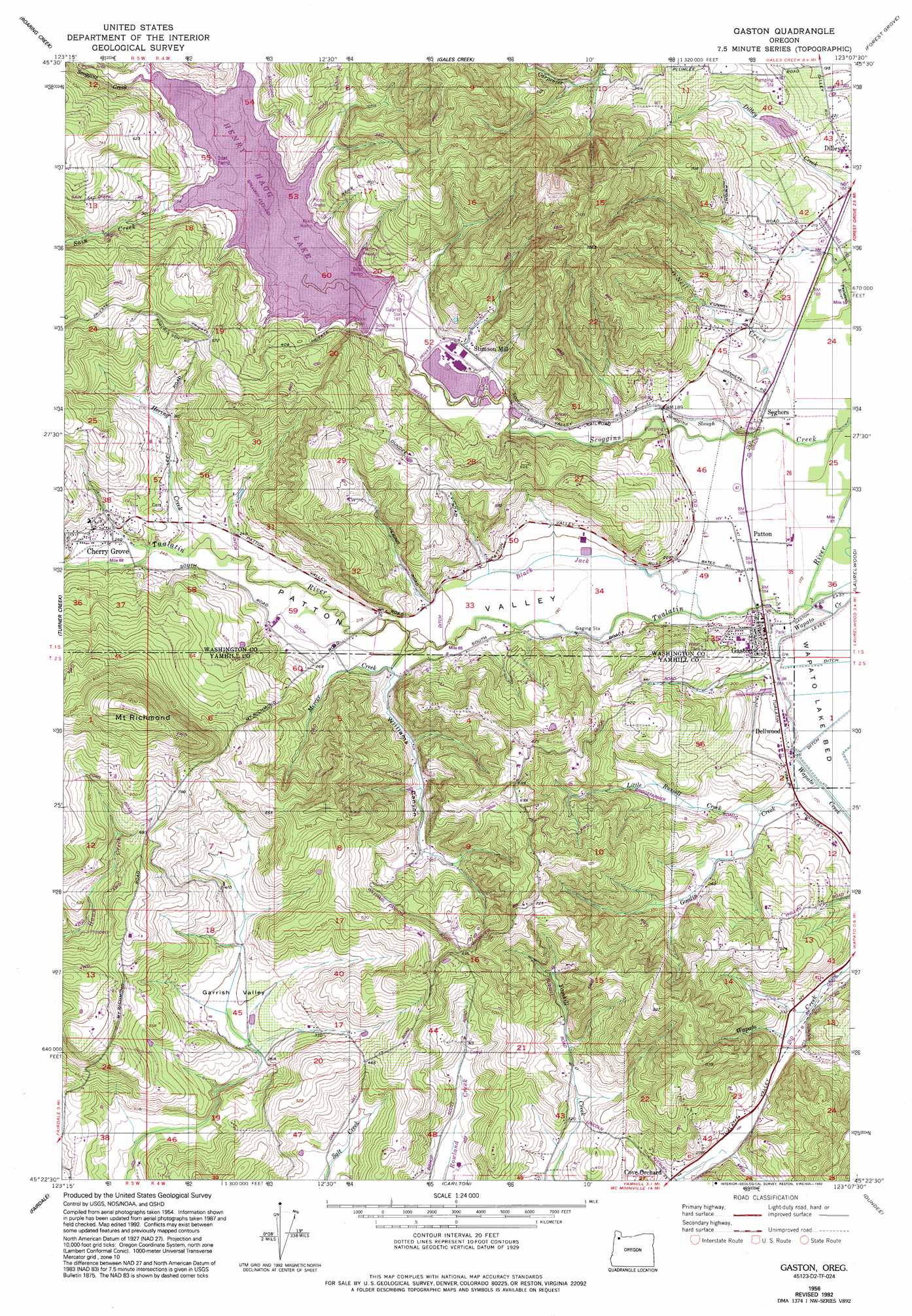
Gaston Topo Map Oregon
To zoom in, hover over the map of Gaston
USGS Topo Quad 45123d2 - 1:24,000 scale
| Topo Map Name: | Gaston |
| USGS Topo Quad ID: | 45123d2 |
| Print Size: | ca. 21 1/4" wide x 27" high |
| Southeast Coordinates: | 45.375° N latitude / 123.125° W longitude |
| Map Center Coordinates: | 45.4375° N latitude / 123.1875° W longitude |
| U.S. State: | OR |
| Filename: | o45123d2.jpg |
| Download Map JPG Image: | Gaston topo map 1:24,000 scale |
| Map Type: | Topographic |
| Topo Series: | 7.5´ |
| Map Scale: | 1:24,000 |
| Source of Map Images: | United States Geological Survey (USGS) |
| Alternate Map Versions: |
Gaston OR 1956, updated 1958 Download PDF Buy paper map Gaston OR 1956, updated 1972 Download PDF Buy paper map Gaston OR 1956, updated 1992 Download PDF Buy paper map Gaston OR 2011 Download PDF Buy paper map Gaston OR 2014 Download PDF Buy paper map |
1:24,000 Topo Quads surrounding Gaston
Cochran |
Timber |
Buxton |
Meacham Corner |
Dixie Mountain |
Wood Point |
Roaring Creek |
Gales Creek |
Forest Grove |
Hillsboro |
Gobblers Knob |
Turner Creek |
Gaston |
Laurelwood |
Scholls |
Trask Mountain |
Fairdale |
Carlton |
Dundee |
Newberg |
Stony Mountain |
Muddy Valley |
Mcminnville |
Dayton |
Saint Paul |
> Back to 45123a1 at 1:100,000 scale
> Back to 45122a1 at 1:250,000 scale
> Back to U.S. Topo Maps home
Gaston topo map: Gazetteer
Gaston: Airports
Western Division Service Center Airport elevation 79m 259′Gaston: Basins
Garrish Valley elevation 90m 295′Gaston: Dams
Bodeen Dam elevation 121m 396′Graham Dam elevation 68m 223′
Scoggins Dam elevation 87m 285′
Gaston: Lakes
Muskrat Pond elevation 71m 232′Gaston: Parks
Henry Hagg County Park elevation 87m 285′Gaston: Populated Places
Cherry Grove elevation 85m 278′Cove Orchard elevation 78m 255′
Gaston elevation 58m 190′
Patton elevation 54m 177′
Gaston: Post Offices
Cherry Grove Post Office (historical) elevation 85m 278′Cove Orchard Post Office (historical) elevation 78m 255′
Gaston Post Office elevation 58m 190′
Seghers Post Office (historical) elevation 53m 173′
Wapatoo Post Office (historical) elevation 57m 187′
Gaston: Reservoirs
Bodeen Lake elevation 121m 396′Earnest Reservoir elevation 179m 587′
Graham Reservoir elevation 68m 223′
Havens Reservoir elevation 55m 180′
Henry Hagg Lake elevation 87m 285′
Phillips Reservoir elevation 181m 593′
Stimson Millpond elevation 64m 209′
Gaston: Streams
Black Jack Creek elevation 53m 173′Dorin Branch elevation 90m 295′
Goodin Creek elevation 52m 170′
Hering Creek elevation 73m 239′
Hill Creek elevation 53m 173′
Little Russell Creek elevation 56m 183′
Mercer Creek elevation 62m 203′
O'Neil Creek elevation 50m 164′
Sain Creek elevation 114m 374′
Scoggins Creek elevation 50m 164′
Scoggins Slough elevation 54m 177′
Gaston: Summits
Mount Richmond elevation 381m 1250′Gaston: Valleys
Patton Valley elevation 53m 173′Scoggins Valley elevation 56m 183′
Williams Canyon elevation 66m 216′
Gaston digital topo map on disk
Buy this Gaston topo map showing relief, roads, GPS coordinates and other geographical features, as a high-resolution digital map file on DVD: