Gobblers Knob Topo Map Oregon
To zoom in, hover over the map of Gobblers Knob
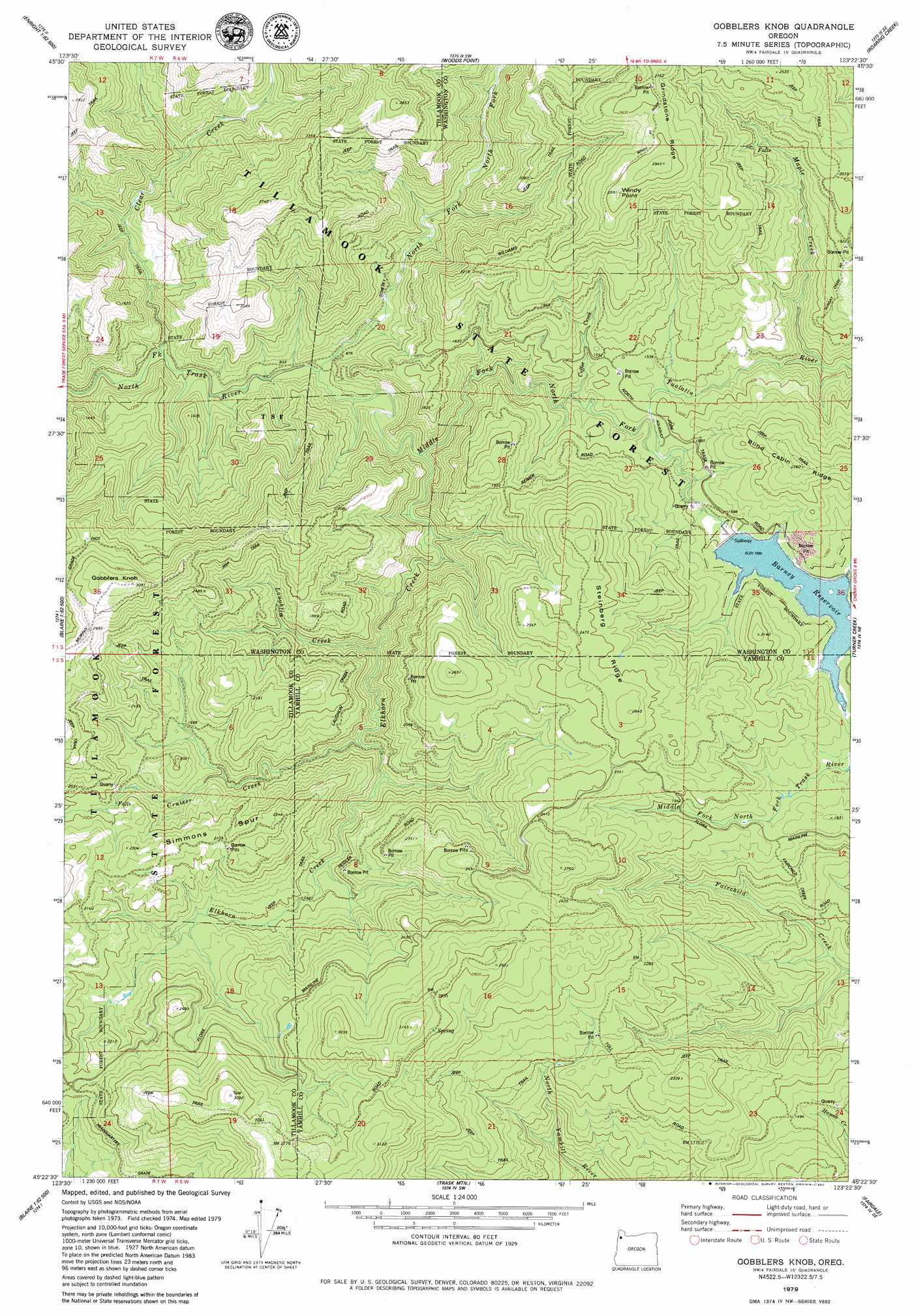
USGS Topo Quad 45123d4 - 1:24,000 scale
| Topo Map Name: | Gobblers Knob |
| USGS Topo Quad ID: | 45123d4 |
| Print Size: | ca. 21 1/4" wide x 27" high |
| Southeast Coordinates: | 45.375° N latitude / 123.375° W longitude |
| Map Center Coordinates: | 45.4375° N latitude / 123.4375° W longitude |
| U.S. State: | OR |
| Filename: | o45123d4.jpg |
| Download Map JPG Image: | Gobblers Knob topo map 1:24,000 scale |
| Map Type: | Topographic |
| Topo Series: | 7.5´ |
| Map Scale: | 1:24,000 |
| Source of Map Images: | United States Geological Survey (USGS) |
| Alternate Map Versions: |
Gobblers Knob OR 1979, updated 1980 Download PDF Buy paper map Gobblers Knob OR 2011 Download PDF Buy paper map Gobblers Knob OR 2014 Download PDF Buy paper map |
1:24,000 Topo Quads surrounding Gobblers Knob
Cook Creek |
Rogers Peak |
Cochran |
Timber |
Buxton |
Cedar Butte |
Jordan Creek |
Wood Point |
Roaring Creek |
Gales Creek |
The Peninsula |
Trask |
Gobblers Knob |
Turner Creek |
Gaston |
Blaine |
Dovre Peak |
Trask Mountain |
Fairdale |
Carlton |
Niagara Creek |
Springer Mountain |
Stony Mountain |
Muddy Valley |
Mcminnville |
> Back to 45123a1 at 1:100,000 scale
> Back to 45122a1 at 1:250,000 scale
> Back to U.S. Topo Maps home
Gobblers Knob topo map: Gazetteer
Gobblers Knob: Dams
Trask River Dam elevation 488m 1601′Gobblers Knob: Falls
Ki-a-Kuts Falls elevation 396m 1299′Gobblers Knob: Post Offices
Larch Post Office (historical) elevation 362m 1187′Gobblers Knob: Reservoirs
Barney Reservoir elevation 488m 1601′Gobblers Knob: Ridges
Simmons Spur elevation 660m 2165′Steinberg Ridge elevation 759m 2490′
Gobblers Knob: Streams
Clear Creek elevation 237m 777′Coffee Creek elevation 412m 1351′
Cruiser Creek elevation 420m 1377′
Elkhorn Creek elevation 311m 1020′
Laughlin Creek elevation 388m 1272′
Maple Creek elevation 335m 1099′
Middle Fork North Fork Trask River elevation 495m 1624′
North Fork North Fork Trask River elevation 261m 856′
Scott Creek elevation 388m 1272′
Gobblers Knob: Summits
Gobblers Knob elevation 932m 3057′Windy Point elevation 880m 2887′
Gobblers Knob digital topo map on disk
Buy this Gobblers Knob topo map showing relief, roads, GPS coordinates and other geographical features, as a high-resolution digital map file on DVD: