Tillamook Topo Map Oregon
To zoom in, hover over the map of Tillamook
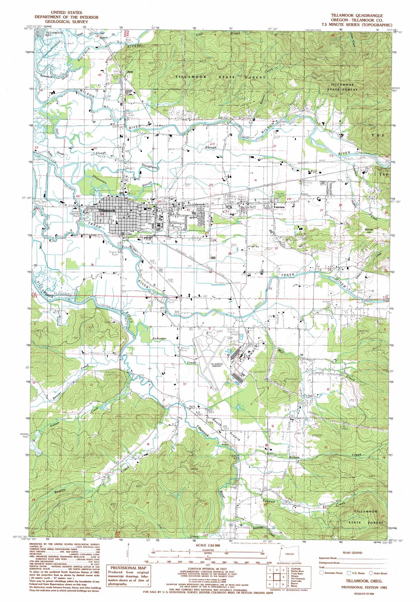
USGS Topo Quad 45123d7 - 1:24,000 scale
| Topo Map Name: | Tillamook |
| USGS Topo Quad ID: | 45123d7 |
| Print Size: | ca. 21 1/4" wide x 27" high |
| Southeast Coordinates: | 45.375° N latitude / 123.75° W longitude |
| Map Center Coordinates: | 45.4375° N latitude / 123.8125° W longitude |
| U.S. State: | OR |
| Filename: | o45123d7.jpg |
| Download Map JPG Image: | Tillamook topo map 1:24,000 scale |
| Map Type: | Topographic |
| Topo Series: | 7.5´ |
| Map Scale: | 1:24,000 |
| Source of Map Images: | United States Geological Survey (USGS) |
| Alternate Map Versions: |
Tillamook NE OR 1975, updated 1980 Download PDF Buy paper map Tillamook OR 1985, updated 1985 Download PDF Buy paper map Tillamook OR 2011 Download PDF Buy paper map Tillamook OR 2014 Download PDF Buy paper map |
| FStopo: | US Forest Service topo Tillamook is available: Download FStopo PDF Download FStopo TIF |
1:24,000 Topo Quads surrounding Tillamook
Nehalem |
Foley Peak |
Cook Creek |
Rogers Peak |
|
Garibaldi |
Kilchis River |
Cedar Butte |
Jordan Creek |
|
Netarts |
Tillamook |
The Peninsula |
Trask |
|
Sand Lake |
Beaver |
Blaine |
Dovre Peak |
|
Nestucca Bay |
Hebo |
Niagara Creek |
Springer Mountain |
> Back to 45123a1 at 1:100,000 scale
> Back to 45122a1 at 1:250,000 scale
> Back to U.S. Topo Maps home
Tillamook topo map: Gazetteer
Tillamook: Airports
Tillamook Airport elevation 10m 32′Tillamook County General Hospital Heliport elevation 7m 22′
Tillamook: Areas
South Prairie elevation 18m 59′Tillamook: Bars
Caufield Bar elevation 9m 29′Clarks Bar elevation 7m 22′
Tillamook: Bends
Ox Bow Bend elevation 2m 6′Tillamook: Bridges
Blaser Bridge elevation 6m 19′Goodspeed Bridge elevation 2m 6′
Johnson Bridge elevation 9m 29′
Makinster Bridge elevation 63m 206′
McKenzie Bridge elevation 5m 16′
Neilson Bridge elevation 9m 29′
Prince Bridge elevation 5m 16′
Sollie Smith Bridge elevation 5m 16′
Stillwell Bridge elevation 2m 6′
Tone Bridge elevation 4m 13′
Tillamook: Flats
South Prairie elevation 11m 36′Tillamook: Guts
Squeedunk Slough elevation 5m 16′Tillamook: Parks
9th Street Park elevation 6m 19′Airbase Reserve County Park elevation 18m 59′
Carnahan Park elevation 4m 13′
Goodspeed Park elevation 8m 26′
Marine Park elevation 3m 9′
Peace Park elevation 7m 22′
Stillwell Park elevation 6m 19′
Tillamook: Populated Places
Fairview elevation 22m 72′Hathaway Mead elevation 13m 42′
Tillamook elevation 8m 26′
Tillamook: Post Offices
Kilchis Post Office (historical) elevation 6m 19′Naval Air Station Post Office (historical) elevation 14m 45′
Nestocton Post Office (historical) elevation 44m 144′
Tillamook Post Office elevation 8m 26′
Tillamook: Reservoirs
Killam Fawcett Reservoir elevation 107m 351′Tillamook Reservoir elevation 75m 246′
Tillamook: Streams
Anderson Creek elevation 2m 6′Bear Creek elevation 8m 26′
Beaver Creek elevation 5m 16′
Beaver Creek elevation 4m 13′
Bewley Creek elevation 6m 19′
Donaldson Creek elevation 13m 42′
Dougherty Slough elevation 3m 9′
Fawcett Creek elevation 19m 62′
Green Creek elevation 8m 26′
Hall Slough elevation 2m 6′
Hoquarten Slough elevation 2m 6′
Hughey Creek elevation 12m 39′
Joe Creek elevation 37m 121′
Kilchis River elevation 4m 13′
Killam Creek elevation 18m 59′
Marys Creek elevation 63m 206′
Mill Creek elevation 7m 22′
Neilson Slough elevation 4m 13′
Nolan Slough elevation 2m 6′
Simmons Creek elevation 33m 108′
Slide Creek elevation 8m 26′
Stasek Slough elevation 4m 13′
Stillwell Ditch elevation 2m 6′
Stillwell Slough elevation 5m 16′
Sutton Creek elevation 5m 16′
Yankee Branch elevation 10m 32′
Tillamook: Summits
Balmer Hill elevation 146m 479′Tillamook digital topo map on disk
Buy this Tillamook topo map showing relief, roads, GPS coordinates and other geographical features, as a high-resolution digital map file on DVD: