Cedar Butte Topo Map Oregon
To zoom in, hover over the map of Cedar Butte
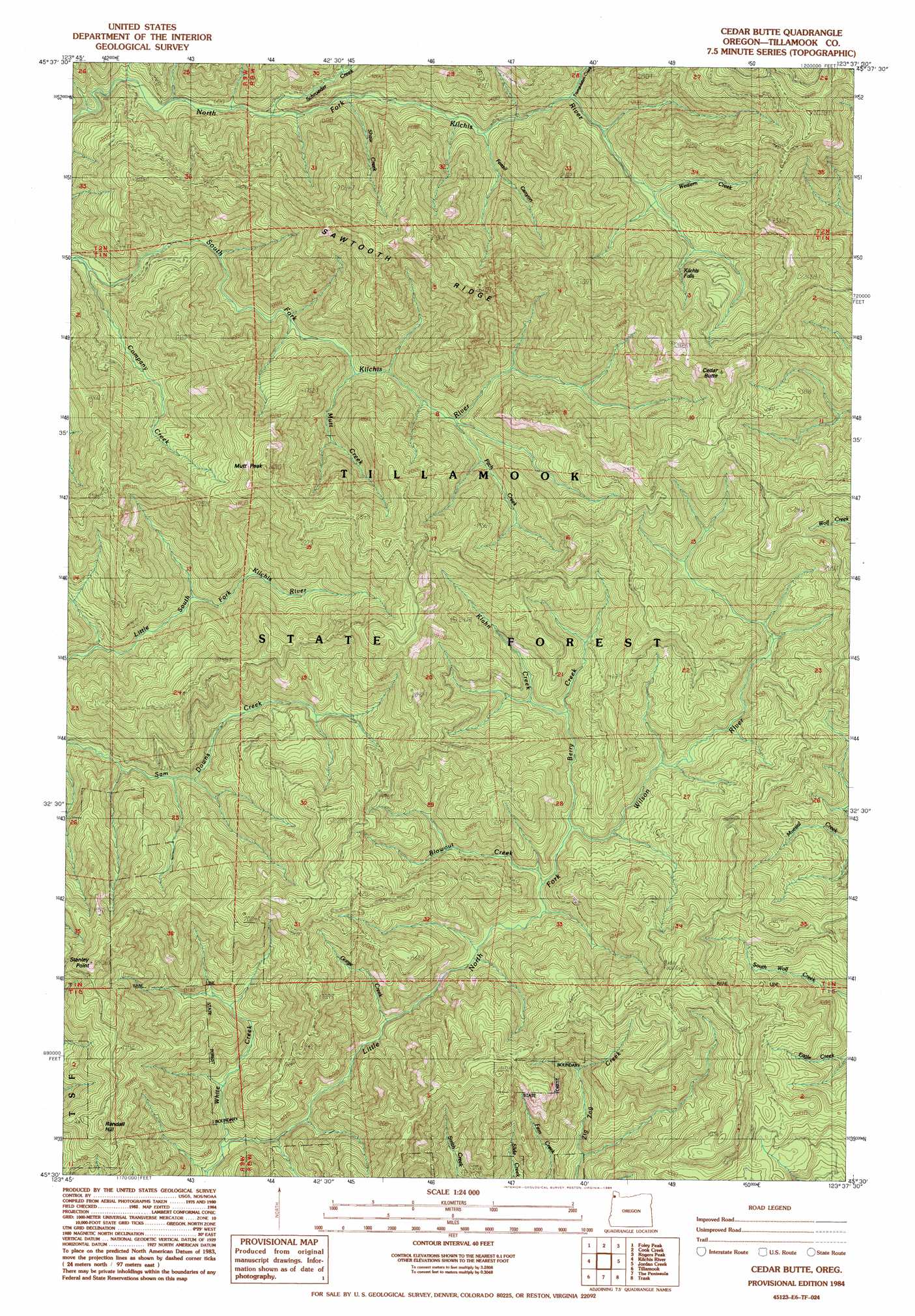
USGS Topo Quad 45123e6 - 1:24,000 scale
| Topo Map Name: | Cedar Butte |
| USGS Topo Quad ID: | 45123e6 |
| Print Size: | ca. 21 1/4" wide x 27" high |
| Southeast Coordinates: | 45.5° N latitude / 123.625° W longitude |
| Map Center Coordinates: | 45.5625° N latitude / 123.6875° W longitude |
| U.S. State: | OR |
| Filename: | o45123e6.jpg |
| Download Map JPG Image: | Cedar Butte topo map 1:24,000 scale |
| Map Type: | Topographic |
| Topo Series: | 7.5´ |
| Map Scale: | 1:24,000 |
| Source of Map Images: | United States Geological Survey (USGS) |
| Alternate Map Versions: |
Cedar Butte OR 1984, updated 1984 Download PDF Buy paper map Cedar Butte OR 2011 Download PDF Buy paper map Cedar Butte OR 2014 Download PDF Buy paper map |
1:24,000 Topo Quads surrounding Cedar Butte
Arch Cape |
Soapstone Lake |
Hamlet |
Elsie |
Sunset Spring |
Nehalem |
Foley Peak |
Cook Creek |
Rogers Peak |
Cochran |
Garibaldi |
Kilchis River |
Cedar Butte |
Jordan Creek |
Wood Point |
Netarts |
Tillamook |
The Peninsula |
Trask |
Gobblers Knob |
Sand Lake |
Beaver |
Blaine |
Dovre Peak |
Trask Mountain |
> Back to 45123e1 at 1:100,000 scale
> Back to 45122a1 at 1:250,000 scale
> Back to U.S. Topo Maps home
Cedar Butte topo map: Gazetteer
Cedar Butte: Falls
Kilchis Falls elevation 406m 1332′Cedar Butte: Ridges
Sawtooth Ridge elevation 758m 2486′Cedar Butte: Streams
Anns Creek elevation 146m 479′Berry Creek elevation 167m 547′
Blowout Creek elevation 153m 501′
Company Creek elevation 124m 406′
Fick Creek elevation 289m 948′
Fitch Creek elevation 248m 813′
George Creek elevation 152m 498′
Gorge Creek elevation 92m 301′
Klahn Creek elevation 219m 718′
Mutt Creek elevation 203m 666′
Ripple Creek elevation 522m 1712′
Rose Creek elevation 143m 469′
Ruth Creek elevation 118m 387′
Schmitz Creek elevation 207m 679′
Schroeder Creek elevation 178m 583′
Shadow Creek elevation 133m 436′
Shaw Creek elevation 199m 652′
Triangulation Creek elevation 286m 938′
Western Creek elevation 329m 1079′
White Creek elevation 59m 193′
Cedar Butte: Summits
Cedar Butte elevation 815m 2673′Mutt Peak elevation 282m 925′
Randall Hill elevation 607m 1991′
Stanley Peak elevation 692m 2270′
Cedar Butte: Valleys
Fossil Canyon elevation 243m 797′Cedar Butte digital topo map on disk
Buy this Cedar Butte topo map showing relief, roads, GPS coordinates and other geographical features, as a high-resolution digital map file on DVD: