Meacham Corner Topo Map Oregon
To zoom in, hover over the map of Meacham Corner
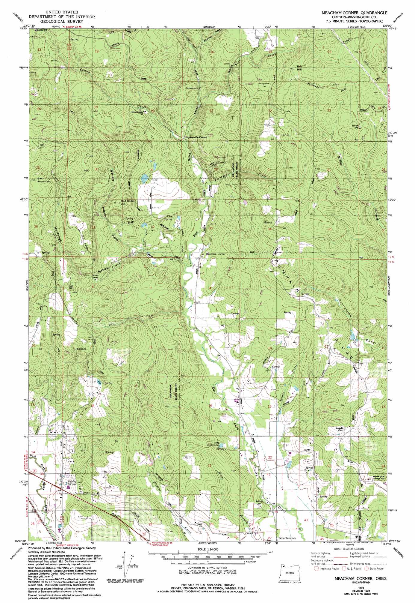
USGS Topo Quad 45123f1 - 1:24,000 scale
| Topo Map Name: | Meacham Corner |
| USGS Topo Quad ID: | 45123f1 |
| Print Size: | ca. 21 1/4" wide x 27" high |
| Southeast Coordinates: | 45.625° N latitude / 123° W longitude |
| Map Center Coordinates: | 45.6875° N latitude / 123.0625° W longitude |
| U.S. State: | OR |
| Filename: | o45123f1.jpg |
| Download Map JPG Image: | Meacham Corner topo map 1:24,000 scale |
| Map Type: | Topographic |
| Topo Series: | 7.5´ |
| Map Scale: | 1:24,000 |
| Source of Map Images: | United States Geological Survey (USGS) |
| Alternate Map Versions: |
Meacham Corner OR 1979, updated 1979 Download PDF Buy paper map Meacham Corner OR 1979, updated 1992 Download PDF Buy paper map Meacham Corner OR 2011 Download PDF Buy paper map Meacham Corner OR 2014 Download PDF Buy paper map |
1:24,000 Topo Quads surrounding Meacham Corner
Birkenfeld |
Pittsburg |
Baker Point |
Trenholm |
Deer Island |
Clear Creek |
Vernonia |
Bacona |
Chapman |
Saint Helens |
Timber |
Buxton |
Meacham Corner |
Dixie Mountain |
Sauvie Island |
Roaring Creek |
Gales Creek |
Forest Grove |
Hillsboro |
Linnton |
Turner Creek |
Gaston |
Laurelwood |
Scholls |
Beaverton |
> Back to 45123e1 at 1:100,000 scale
> Back to 45122a1 at 1:250,000 scale
> Back to U.S. Topo Maps home
Meacham Corner topo map: Gazetteer
Meacham Corner: Basins
Hidden Valley elevation 273m 895′Meacham Corner: Dams
Ornoname 22 Dam elevation 300m 984′Meacham Corner: Flats
Burgdorfer Flat elevation 412m 1351′Meacham Corner: Lakes
Welches Pond elevation 131m 429′Meacham Corner: Parks
Little Bend Park (historical) elevation 184m 603′Meacham Corner: Populated Places
Dixie (historical) elevation 500m 1640′Meacham Corner: Post Offices
Dixie Post Office (historical) elevation 500m 1640′Meacham Corner: Reservoirs
Bateman Reservoir elevation 134m 439′Bump Reservoir elevation 301m 987′
Dam Site Reservoir elevation 178m 583′
Horning Reservoir elevation 230m 754′
Rails End Reservoir elevation 112m 367′
Rebart Reservoir elevation 419m 1374′
Spaniol Reservoir elevation 223m 731′
Sunago Reservoir elevation 314m 1030′
Meacham Corner: Ridges
Pumpkin Ridge elevation 249m 816′Meacham Corner: Springs
Fern Spring elevation 197m 646′Shipley Springs elevation 70m 229′
Meacham Corner: Streams
Denny Creek elevation 158m 518′East Gumm Creek elevation 67m 219′
Grebe Creek elevation 177m 580′
Gumm Creek elevation 72m 236′
Meadow Brook elevation 109m 357′
Murtaugh Creek elevation 107m 351′
Panther Creek elevation 232m 761′
Plentywater Creek elevation 134m 439′
Rock Creek elevation 193m 633′
Whiskey Creek elevation 176m 577′
Meacham Corner: Summits
Bald Mountain elevation 540m 1771′Red Slide Hill elevation 473m 1551′
Rye Hill elevation 566m 1856′
Meacham Corner: Valleys
Big Canyon elevation 98m 321′Meacham Corner digital topo map on disk
Buy this Meacham Corner topo map showing relief, roads, GPS coordinates and other geographical features, as a high-resolution digital map file on DVD: