Buxton Topo Map Oregon
To zoom in, hover over the map of Buxton
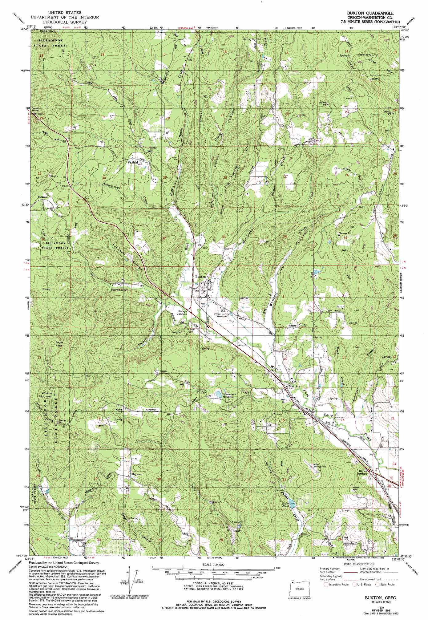
USGS Topo Quad 45123f2 - 1:24,000 scale
| Topo Map Name: | Buxton |
| USGS Topo Quad ID: | 45123f2 |
| Print Size: | ca. 21 1/4" wide x 27" high |
| Southeast Coordinates: | 45.625° N latitude / 123.125° W longitude |
| Map Center Coordinates: | 45.6875° N latitude / 123.1875° W longitude |
| U.S. State: | OR |
| Filename: | o45123f2.jpg |
| Download Map JPG Image: | Buxton topo map 1:24,000 scale |
| Map Type: | Topographic |
| Topo Series: | 7.5´ |
| Map Scale: | 1:24,000 |
| Source of Map Images: | United States Geological Survey (USGS) |
| Alternate Map Versions: |
Buxton OR 1979, updated 1979 Download PDF Buy paper map Buxton OR 1979, updated 1992 Download PDF Buy paper map Buxton OR 2011 Download PDF Buy paper map Buxton OR 2014 Download PDF Buy paper map |
1:24,000 Topo Quads surrounding Buxton
Sager Creek |
Birkenfeld |
Pittsburg |
Baker Point |
Trenholm |
Sunset Spring |
Clear Creek |
Vernonia |
Bacona |
Chapman |
Cochran |
Timber |
Buxton |
Meacham Corner |
Dixie Mountain |
Wood Point |
Roaring Creek |
Gales Creek |
Forest Grove |
Hillsboro |
Gobblers Knob |
Turner Creek |
Gaston |
Laurelwood |
Scholls |
> Back to 45123e1 at 1:100,000 scale
> Back to 45122a1 at 1:250,000 scale
> Back to U.S. Topo Maps home
Buxton topo map: Gazetteer
Buxton: Airports
Hester Landing Strip elevation 199m 652′Buxton: Parks
Banks-Vernonia State Trail elevation 72m 236′Buxton: Populated Places
Buxton elevation 100m 328′Hayward elevation 341m 1118′
Manning elevation 74m 242′
Buxton: Post Offices
Bacona Post Office (historical) elevation 543m 1781′Buxton Post Office elevation 100m 328′
Hayward Post Office (historical) elevation 341m 1118′
Manning Post Office elevation 74m 242′
Scofield Post Office (historical) elevation 197m 646′
Strassel Post Office (historical) elevation 304m 997′
Buxton: Reservoirs
Green Valley Reservoir elevation 81m 265′Hofer Pond elevation 63m 206′
Schmadeke Reservoir elevation 184m 603′
Whiteman Pond elevation 71m 232′
Buxton: Streams
Brooke Creek elevation 166m 544′Burgholzer Creek elevation 80m 262′
Buxton Creek elevation 154m 505′
Cummings Creek elevation 99m 324′
Garrigus Creek elevation 65m 213′
Kuder Creek elevation 69m 226′
Logging Creek elevation 130m 426′
Mendenhall Creek elevation 79m 259′
Rock Creek elevation 67m 219′
Strassel Creek elevation 186m 610′
Whitcher Creek elevation 74m 242′
Williams Creek elevation 85m 278′
Buxton: Summits
Cape Horn elevation 498m 1633′Eagle Peak elevation 492m 1614′
Green Mountain elevation 677m 2221′
Wildcat Mountain elevation 538m 1765′
Buxton: Valleys
Hares Canyon elevation 97m 318′Paisley Canyon elevation 83m 272′
Poliwaski Canyon elevation 92m 301′
Tolke Canyon elevation 93m 305′
Buxton digital topo map on disk
Buy this Buxton topo map showing relief, roads, GPS coordinates and other geographical features, as a high-resolution digital map file on DVD: