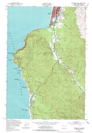
Tillamook Head Topo Map Oregon
To zoom in, hover over the map of Tillamook Head
USGS Topo Quad 45123h8 - 1:24,000 scale
| Topo Map Name: | Tillamook Head |
| USGS Topo Quad ID: | 45123h8 |
| Print Size: | ca. 21 1/4" wide x 27" high |
| Southeast Coordinates: | 45.875° N latitude / 123.875° W longitude |
| Map Center Coordinates: | 45.9375° N latitude / 123.9375° W longitude |
| U.S. State: | OR |
| Filename: | o45123h8.jpg |
| Download Map JPG Image: | Tillamook Head topo map 1:24,000 scale |
| Map Type: | Topographic |
| Topo Series: | 7.5´ |
| Map Scale: | 1:24,000 |
| Source of Map Images: | United States Geological Survey (USGS) |
| Alternate Map Versions: |
Tillamook Head OR 1949, updated 1955 Download PDF Buy paper map Tillamook Head OR 1949, updated 1966 Download PDF Buy paper map Tillamook Head OR 1949, updated 1978 Download PDF Buy paper map Tillamook Head OR 2011 Download PDF Buy paper map Tillamook Head OR 2014 Download PDF Buy paper map |
1:24,000 Topo Quads surrounding Tillamook Head
Clatsop Spit |
Warrenton |
Astoria |
Cathlamet Bay |
|
Gearhart |
Olney |
Green Mountain |
||
Tillamook Head |
Necanicum Junction |
Saddle Mountain |
||
Arch Cape |
Soapstone Lake |
Hamlet |
||
Nehalem |
Foley Peak |
Cook Creek |
> Back to 45123e1 at 1:100,000 scale
> Back to 45122a1 at 1:250,000 scale
> Back to U.S. Topo Maps home
Tillamook Head topo map: Gazetteer
Tillamook Head: Arches
Sea Lion Rock Arch elevation 11m 36′Tillamook Head: Basins
Bear Valley elevation 2m 6′Tillamook Head: Beaches
Cannon Beach elevation 5m 16′Chapman Beach elevation 13m 42′
Crescent Beach elevation 11m 36′
Indian Beach elevation 7m 22′
Sunset Beach elevation 32m 104′
Tillamook Head: Bridges
Skibbereen Bridge elevation 10m 32′Tillamook Head: Capes
Bailey Point elevation 162m 531′Bald Point elevation 6m 19′
Bird Point elevation 32m 104′
Chapman Point elevation 32m 104′
Ecola Point elevation 1m 3′
Indian Point elevation 13m 42′
Kramer Point elevation 0m 0′
Tillamook Head elevation 161m 528′
West Point elevation 4m 13′
Tillamook Head: Islands
Bird Rocks elevation 0m 0′Haystack Rock elevation 44m 144′
Sea Lion Rock elevation 11m 36′
Submarine Rock elevation 1m 3′
The Needles elevation 0m 0′
Tillamook Head: Lakes
Mantel Lake elevation 2m 6′Riverside Lake elevation 59m 193′
Tillamook Head: Parks
Ecola State Park elevation 150m 492′Elmer Feldenheimer State Park elevation 7m 22′
Haystack Hill State Park elevation 33m 108′
John Yeon State Park elevation 9m 29′
Les Shirley Park elevation 12m 39′
Lewis and Clark Salt Cairn Historic Monument elevation 2m 6′
Necanicum Picnic Area elevation 25m 82′
Nehalem H Street Dock elevation 356m 1167′
Tillamook Head: Populated Places
Cannon Beach elevation 5m 16′Seaside elevation 2m 6′
Tillamook Head: Post Offices
Ben Holladay Post Office (historical) elevation 3m 9′Cannon Beach Post Office elevation 5m 16′
Peris Post Office (historical) elevation 81m 265′
Seaside House Post Office (historical) elevation 2m 6′
Seaside Post Office elevation 2m 6′
Tillamook Head: Reservoirs
Chapman Ponds elevation 2m 6′Seaside Reservoir elevation 50m 164′
Tillamook Head: Springs
Hoover Spring elevation 59m 193′Tillamook Head: Streams
Beerman Creek elevation 6m 19′Canyon Creek elevation 4m 13′
Circle Creek elevation 5m 16′
Crescent Creek elevation 0m 0′
Ecola Creek elevation 1m 3′
Indian Creek elevation 5m 16′
Johnson Creek elevation 32m 104′
Klootchie Creek elevation 30m 98′
Little Muddy Creek elevation 4m 13′
Logan Creek elevation 3m 9′
Meyer Creek elevation 14m 45′
North Fork Ecola Creek elevation 9m 29′
Salmon Creek elevation 29m 95′
Shangrila Creek elevation 4m 13′
Tillangora Creek elevation 0m 0′
Volmer Creek elevation 25m 82′
Waterfall Creek elevation 4m 13′
West Fork Ecola Creek elevation 9m 29′
Williamson Creek elevation 8m 26′
Tillamook Head: Summits
Bald Mountain elevation 230m 754′Clark's Mountain elevation 382m 1253′
Rippet Mountain elevation 123m 403′
Tillamook Head: Trails
Cannon Beach Trail elevation 306m 1003′Tillamook Head digital topo map on disk
Buy this Tillamook Head topo map showing relief, roads, GPS coordinates and other geographical features, as a high-resolution digital map file on DVD:


