Smyrna Mills Topo Map Maine
To zoom in, hover over the map of Smyrna Mills
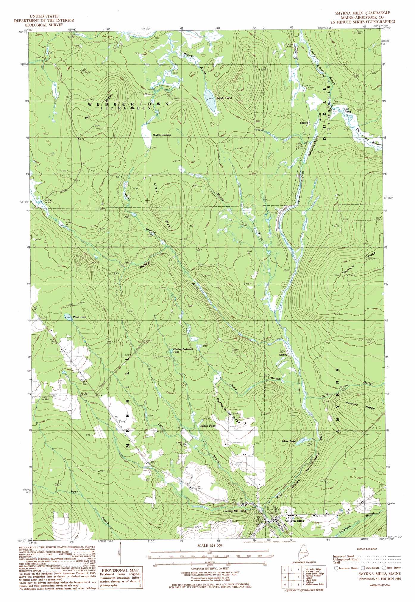
USGS Topo Quad 46068b2 - 1:24,000 scale
| Topo Map Name: | Smyrna Mills |
| USGS Topo Quad ID: | 46068b2 |
| Print Size: | ca. 21 1/4" wide x 27" high |
| Southeast Coordinates: | 46.125° N latitude / 68.125° W longitude |
| Map Center Coordinates: | 46.1875° N latitude / 68.1875° W longitude |
| U.S. State: | ME |
| Filename: | o46068b2.jpg |
| Download Map JPG Image: | Smyrna Mills topo map 1:24,000 scale |
| Map Type: | Topographic |
| Topo Series: | 7.5´ |
| Map Scale: | 1:24,000 |
| Source of Map Images: | United States Geological Survey (USGS) |
| Alternate Map Versions: |
Smyrna Mills NW ME 1975, updated 1980 Download PDF Buy paper map Smyrna Mills ME 1986, updated 1986 Download PDF Buy paper map Smyrna Mills ME 2011 Download PDF Buy paper map Smyrna Mills ME 2014 Download PDF Buy paper map |
1:24,000 Topo Quads surrounding Smyrna Mills
Oxbow East |
Griswold |
Spinney Brook |
Number Nine Lake |
Packard Lake |
Umcolcus Lake |
Mcnally Ridge |
Saint Croix Lake |
North Brook Ridge |
Harvey |
Green Mountain |
Knowles Corner |
Smyrna Mills |
Ludlow |
Twin Brook |
Mount Chase |
Island Falls |
Oakfield |
Meduxnekeag Lake |
Linneus |
Patten |
Crystal |
Mattawamkeag Lake |
Monument Brook |
Ten Mile Lake |
> Back to 46068a1 at 1:100,000 scale
> Back to 46068a1 at 1:250,000 scale
> Back to U.S. Topo Maps home
Smyrna Mills topo map: Gazetteer
Smyrna Mills: Lakes
Brandy Pond elevation 235m 770′Charley Anderson Pond elevation 249m 816′
Cut Pond elevation 215m 705′
Huntley Mill Pond elevation 209m 685′
Read Lake elevation 324m 1062′
Roach Pond elevation 219m 718′
White Lake elevation 194m 636′
Smyrna Mills: Populated Places
Dudley elevation 200m 656′Hillman elevation 210m 688′
Shorey elevation 217m 711′
Smyrna Mills elevation 175m 574′
Smyrna Mills: Ridges
Dudley Brook Ridge elevation 247m 810′Emerson Ridge elevation 310m 1017′
Pervere Ridge elevation 262m 859′
Smyrna Mills: Streams
Cold Brook elevation 180m 590′Cut Pond Brook elevation 217m 711′
Duck Pond Outlet elevation 193m 633′
Dudley Brook elevation 199m 652′
Moose Brook elevation 203m 666′
North Branch Dudley Brook elevation 235m 770′
Soule Brook elevation 195m 639′
Smyrna Mills: Summits
Big Brawn elevation 318m 1043′Little Brawn elevation 301m 987′
Smyrna Mills: Swamps
Dudley Swamp elevation 263m 862′Smyrna Mills digital topo map on disk
Buy this Smyrna Mills topo map showing relief, roads, GPS coordinates and other geographical features, as a high-resolution digital map file on DVD:
Maine, New Hampshire, Rhode Island & Eastern Massachusetts
Buy digital topo maps: Maine, New Hampshire, Rhode Island & Eastern Massachusetts