Hay Brook Mountain Topo Map Maine
To zoom in, hover over the map of Hay Brook Mountain
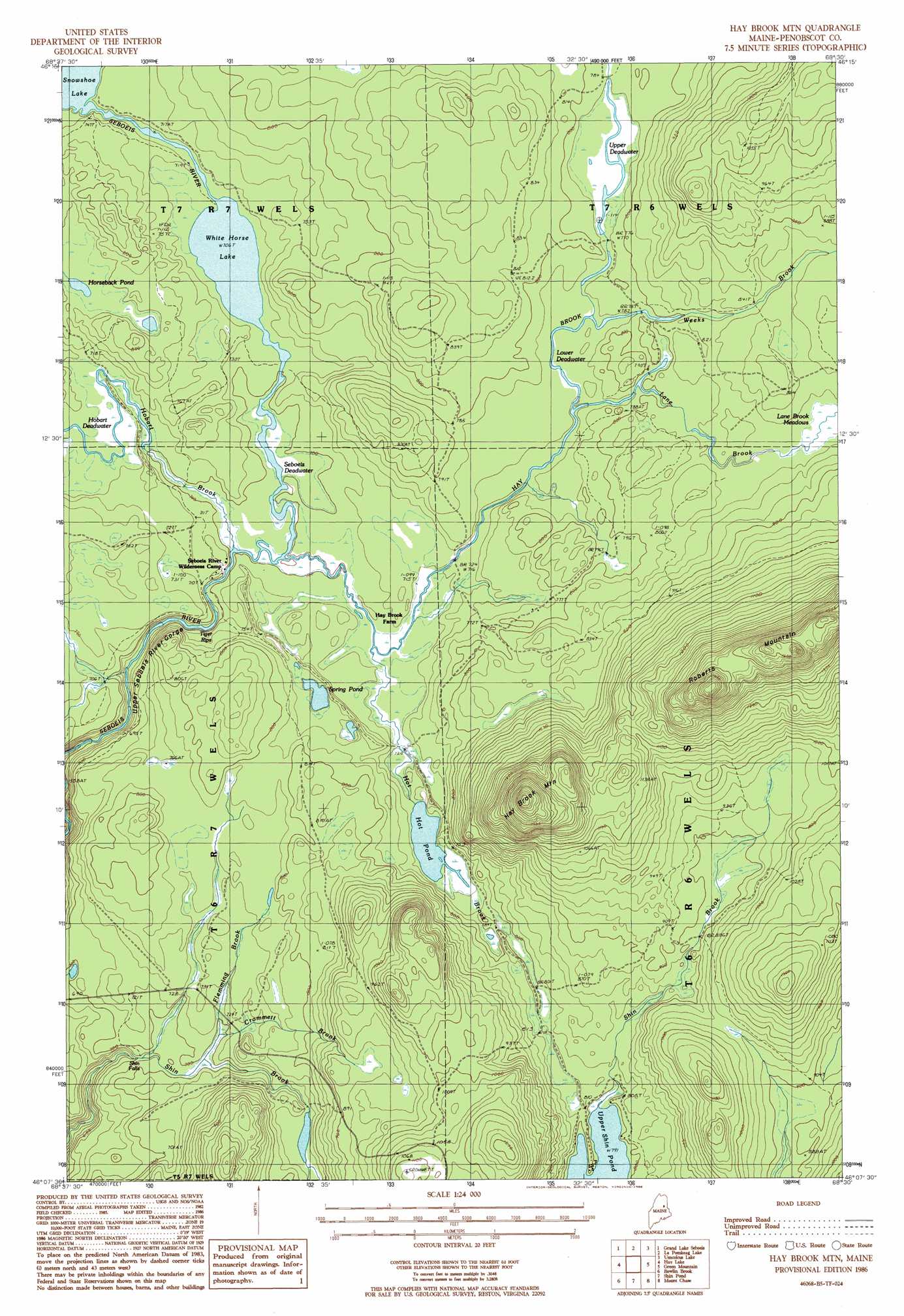
USGS Topo Quad 46068b5 - 1:24,000 scale
| Topo Map Name: | Hay Brook Mountain |
| USGS Topo Quad ID: | 46068b5 |
| Print Size: | ca. 21 1/4" wide x 27" high |
| Southeast Coordinates: | 46.125° N latitude / 68.5° W longitude |
| Map Center Coordinates: | 46.1875° N latitude / 68.5625° W longitude |
| U.S. State: | ME |
| Filename: | o46068b5.jpg |
| Download Map JPG Image: | Hay Brook Mountain topo map 1:24,000 scale |
| Map Type: | Topographic |
| Topo Series: | 7.5´ |
| Map Scale: | 1:24,000 |
| Source of Map Images: | United States Geological Survey (USGS) |
| Alternate Map Versions: |
Shin Pond NE ME 1975, updated 1980 Download PDF Buy paper map Hay Brook Mtn ME 1986, updated 1986 Download PDF Buy paper map Hay Brook Mountain ME 2011 Download PDF Buy paper map Hay Brook Mountain ME 2014 Download PDF Buy paper map |
1:24,000 Topo Quads surrounding Hay Brook Mountain
Middle Brook Mountain |
Chandler Mountain |
Oxbow West |
Oxbow East |
Griswold |
Millinocket Lake East |
Grand Lake Seboeis |
La Pomkeag Lake |
Umcolcus Lake |
Mcnally Ridge |
Trout Brook Mountain |
Hay Lake |
Hay Brook Mountain |
Green Mountain |
Knowles Corner |
The Traveler |
Bowlin Brook |
Shin Pond |
Mount Chase |
Island Falls |
Katahdin Lake |
Deasey Mountain |
Lookout Mountain |
Patten |
Crystal |
> Back to 46068a1 at 1:100,000 scale
> Back to 46068a1 at 1:250,000 scale
> Back to U.S. Topo Maps home
Hay Brook Mountain topo map: Gazetteer
Hay Brook Mountain: Falls
Shin Falls elevation 203m 666′Hay Brook Mountain: Lakes
Horseback Pond elevation 230m 754′Hot Pond elevation 222m 728′
Lower Deadwater elevation 233m 764′
Seboeis Deadwater elevation 212m 695′
Spring Pond elevation 225m 738′
Upper Deadwater elevation 237m 777′
White Horse Lake elevation 215m 705′
Hay Brook Mountain: Rapids
Tiger Rips elevation 206m 675′Hay Brook Mountain: Streams
Crommett Brook elevation 213m 698′Flemming Brook elevation 211m 692′
Hay Brook elevation 212m 695′
Hobart Brook elevation 212m 695′
Hot Brook elevation 216m 708′
Lane Brook elevation 231m 757′
Shin Brook elevation 242m 793′
Weeks Brook elevation 236m 774′
Hay Brook Mountain: Summits
Hay Brook Mountain elevation 489m 1604′Roberts Mountain elevation 488m 1601′
Hay Brook Mountain: Swamps
Hobart Deadwater elevation 215m 705′Hay Brook Mountain digital topo map on disk
Buy this Hay Brook Mountain topo map showing relief, roads, GPS coordinates and other geographical features, as a high-resolution digital map file on DVD:
Maine, New Hampshire, Rhode Island & Eastern Massachusetts
Buy digital topo maps: Maine, New Hampshire, Rhode Island & Eastern Massachusetts