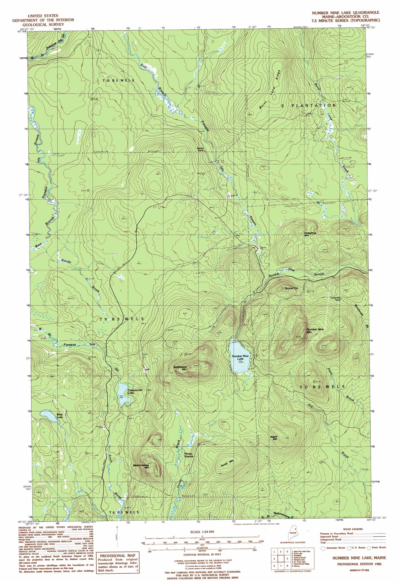
Number Nine Lake Topo Map Maine
To zoom in, hover over the map of Number Nine Lake
USGS Topo Quad 46068d1 - 1:24,000 scale
| Topo Map Name: | Number Nine Lake |
| USGS Topo Quad ID: | 46068d1 |
| Print Size: | ca. 21 1/4" wide x 27" high |
| Southeast Coordinates: | 46.375° N latitude / 68° W longitude |
| Map Center Coordinates: | 46.4375° N latitude / 68.0625° W longitude |
| U.S. State: | ME |
| Filename: | o46068d1.jpg |
| Download Map JPG Image: | Number Nine Lake topo map 1:24,000 scale |
| Map Type: | Topographic |
| Topo Series: | 7.5´ |
| Map Scale: | 1:24,000 |
| Source of Map Images: | United States Geological Survey (USGS) |
| Alternate Map Versions: |
Howe Brook NE ME 1975, updated 1981 Download PDF Buy paper map Number Nine Lake ME 1986, updated 1987 Download PDF Buy paper map Number Nine Lake ME 2011 Download PDF Buy paper map Number Nine Lake ME 2014 Download PDF Buy paper map |
1:24,000 Topo Quads surrounding Number Nine Lake
York Ridge |
Mapleton |
Presque Isle |
Easton |
Easton Center |
Squa Pan Lake West |
Squa Pan Lake East |
Echo Lake |
Westfield |
Mars Hill |
Griswold |
Spinney Brook |
Number Nine Lake |
Packard Lake |
Bridgewater |
Mcnally Ridge |
Saint Croix Lake |
North Brook Ridge |
Harvey |
Monticello |
Knowles Corner |
Smyrna Mills |
Ludlow |
Twin Brook |
Houlton North |
> Back to 46068a1 at 1:100,000 scale
> Back to 46068a1 at 1:250,000 scale
> Back to U.S. Topo Maps home
Number Nine Lake topo map: Gazetteer
Number Nine Lake: Lakes
Number Nine Lake elevation 330m 1082′Presque Isle Lake elevation 276m 905′
West Lake elevation 297m 974′
Number Nine Lake: Ridges
Burnt Land Ridge elevation 336m 1102′Number Nine Lake: Streams
Brandy Brook elevation 248m 813′Number Nine Lake: Summits
Hedgehog Mountain elevation 329m 1079′Hovey Mountain elevation 415m 1361′
Maple Mountain elevation 411m 1348′
Meduxnekeag Mountain elevation 403m 1322′
Number Nine Mountain elevation 493m 1617′
Saddleback Mountain elevation 505m 1656′
Spruce Top elevation 360m 1181′
Number Nine Lake: Swamps
Hovey Swamp elevation 330m 1082′Number Nine Lake digital topo map on disk
Buy this Number Nine Lake topo map showing relief, roads, GPS coordinates and other geographical features, as a high-resolution digital map file on DVD:
Maine, New Hampshire, Rhode Island & Eastern Massachusetts
Buy digital topo maps: Maine, New Hampshire, Rhode Island & Eastern Massachusetts