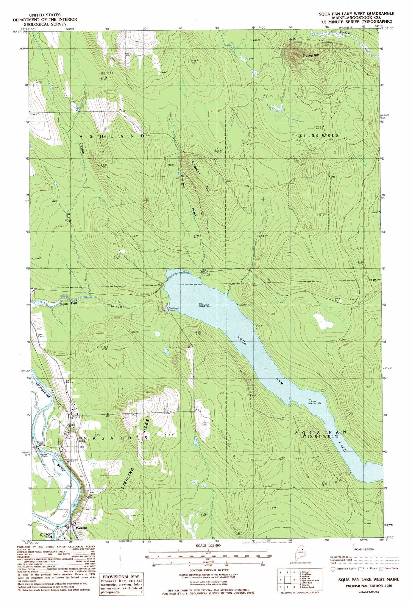
Squa Pan Lake West Topo Map Maine
To zoom in, hover over the map of Squa Pan Lake West
USGS Topo Quad 46068e3 - 1:24,000 scale
| Topo Map Name: | Squa Pan Lake West |
| USGS Topo Quad ID: | 46068e3 |
| Print Size: | ca. 21 1/4" wide x 27" high |
| Southeast Coordinates: | 46.5° N latitude / 68.25° W longitude |
| Map Center Coordinates: | 46.5625° N latitude / 68.3125° W longitude |
| U.S. State: | ME |
| Filename: | o46068e3.jpg |
| Download Map JPG Image: | Squa Pan Lake West topo map 1:24,000 scale |
| Map Type: | Topographic |
| Topo Series: | 7.5´ |
| Map Scale: | 1:24,000 |
| Source of Map Images: | United States Geological Survey (USGS) |
| Alternate Map Versions: |
Ashland SE ME 1975, updated 1981 Download PDF Buy paper map Squa Pan Lake West ME 1986, updated 1986 Download PDF Buy paper map Scopan Lake West ME 2011 Download PDF Buy paper map Scopan Lake West ME 2014 Download PDF Buy paper map |
1:24,000 Topo Quads surrounding Squa Pan Lake West
Portage Lake West |
Portage Lake East |
Bull Brook |
Washburn |
Caribou |
Little Machias Lake |
Ashland |
York Ridge |
Mapleton |
Presque Isle |
Forks Of Machias |
Squa Pan |
Squa Pan Lake West |
Squa Pan Lake East |
Echo Lake |
Oxbow West |
Oxbow East |
Griswold |
Spinney Brook |
Number Nine Lake |
La Pomkeag Lake |
Umcolcus Lake |
Mcnally Ridge |
Saint Croix Lake |
North Brook Ridge |
> Back to 46068e1 at 1:100,000 scale
> Back to 46068a1 at 1:250,000 scale
> Back to U.S. Topo Maps home
Squa Pan Lake West topo map: Gazetteer
Squa Pan Lake West: Dams
Squapan Dam elevation 183m 600′Squa Pan Lake West: Populated Places
Masardis elevation 172m 564′Squa Pan Lake West: Post Offices
Masardis Post Office elevation 171m 561′Squa Pan Lake West: Reservoirs
Squapan Lake elevation 183m 600′Squa Pan Lake West: Ridges
Sterling Ridge elevation 257m 843′Squa Pan Lake West: Streams
Clayton Brook elevation 169m 554′Nowland Brook elevation 183m 600′
Saint Croix Stream elevation 164m 538′
Squa Pan Lake West: Summits
Brushy Hill elevation 282m 925′Midway Siding elevation 216m 708′
Nowland Hill elevation 268m 879′
Nowland Siding elevation 189m 620′
Squa Pan Lake West: Trails
Old Dam Tote Road elevation 210m 688′Squa Pan Lake West digital topo map on disk
Buy this Squa Pan Lake West topo map showing relief, roads, GPS coordinates and other geographical features, as a high-resolution digital map file on DVD:
Maine, New Hampshire, Rhode Island & Eastern Massachusetts
Buy digital topo maps: Maine, New Hampshire, Rhode Island & Eastern Massachusetts