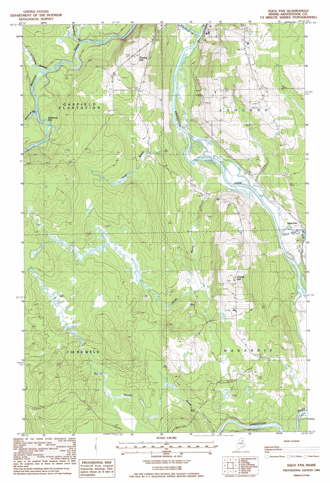
Squa Pan Topo Map Maine
To zoom in, hover over the map of Squa Pan
USGS Topo Quad 46068e4 - 1:24,000 scale
| Topo Map Name: | Squa Pan |
| USGS Topo Quad ID: | 46068e4 |
| Print Size: | ca. 21 1/4" wide x 27" high |
| Southeast Coordinates: | 46.5° N latitude / 68.375° W longitude |
| Map Center Coordinates: | 46.5625° N latitude / 68.4375° W longitude |
| U.S. State: | ME |
| Filename: | o46068e4.jpg |
| Download Map JPG Image: | Squa Pan topo map 1:24,000 scale |
| Map Type: | Topographic |
| Topo Series: | 7.5´ |
| Map Scale: | 1:24,000 |
| Source of Map Images: | United States Geological Survey (USGS) |
| Alternate Map Versions: |
Ashland SW ME 1975, updated 1981 Download PDF Buy paper map Squa Pan ME 1986, updated 1986 Download PDF Buy paper map Scopan ME 2011 Download PDF Buy paper map Scopan ME 2014 Download PDF Buy paper map |
1:24,000 Topo Quads surrounding Squa Pan
Carr Pond |
Portage Lake West |
Portage Lake East |
Bull Brook |
Washburn |
Greenlaw Pond |
Little Machias Lake |
Ashland |
York Ridge |
Mapleton |
Jack Mountain |
Forks Of Machias |
Squa Pan |
Squa Pan Lake West |
Squa Pan Lake East |
Chandler Mountain |
Oxbow West |
Oxbow East |
Griswold |
Spinney Brook |
Grand Lake Seboeis |
La Pomkeag Lake |
Umcolcus Lake |
Mcnally Ridge |
Saint Croix Lake |
> Back to 46068e1 at 1:100,000 scale
> Back to 46068a1 at 1:250,000 scale
> Back to U.S. Topo Maps home
Squa Pan topo map: Gazetteer
Squa Pan: Airports
Ashland Airport elevation 224m 734′Squa Pan: Populated Places
Squapan elevation 165m 541′Squa Pan: Streams
Fourmile Brook elevation 180m 590′Greenlaw Stream elevation 178m 583′
Horse Brook elevation 159m 521′
Machias River elevation 162m 531′
Shields Brook elevation 175m 574′
Squapan Stream elevation 163m 534′
Trout Brook elevation 162m 531′
Squa Pan: Summits
Grove Hill elevation 247m 810′Young Hill elevation 246m 807′
Squa Pan digital topo map on disk
Buy this Squa Pan topo map showing relief, roads, GPS coordinates and other geographical features, as a high-resolution digital map file on DVD:
Maine, New Hampshire, Rhode Island & Eastern Massachusetts
Buy digital topo maps: Maine, New Hampshire, Rhode Island & Eastern Massachusetts