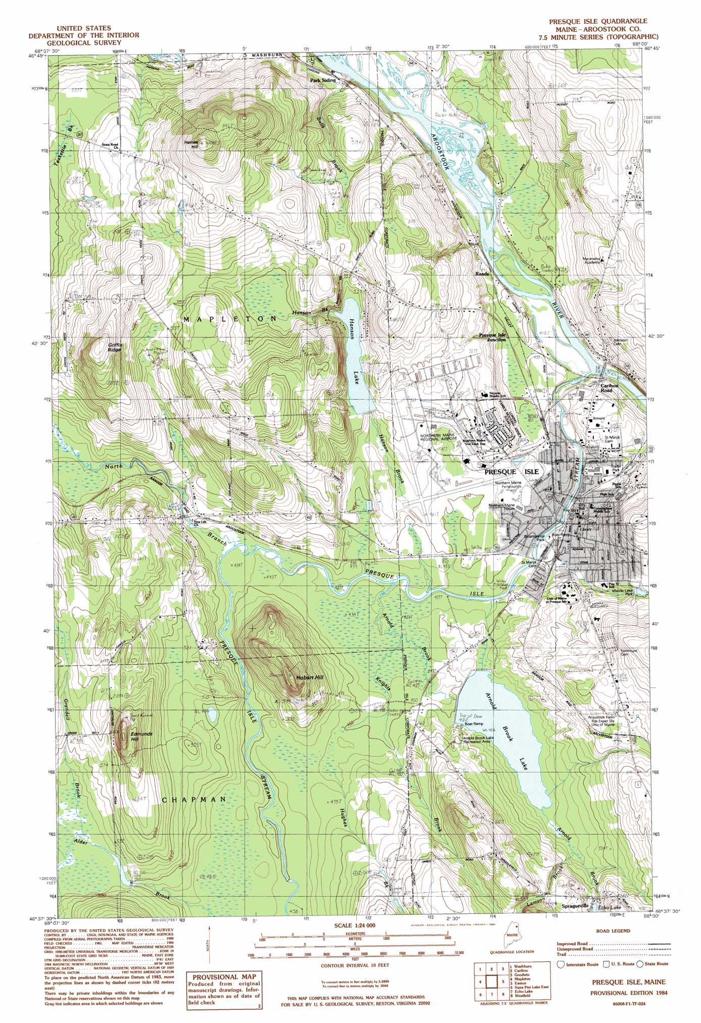
Presque Isle Topo Map Maine
To zoom in, hover over the map of Presque Isle
USGS Topo Quad 46068f1 - 1:24,000 scale
| Topo Map Name: | Presque Isle |
| USGS Topo Quad ID: | 46068f1 |
| Print Size: | ca. 21 1/4" wide x 27" high |
| Southeast Coordinates: | 46.625° N latitude / 68° W longitude |
| Map Center Coordinates: | 46.6875° N latitude / 68.0625° W longitude |
| U.S. State: | ME |
| Filename: | o46068f1.jpg |
| Download Map JPG Image: | Presque Isle topo map 1:24,000 scale |
| Map Type: | Topographic |
| Topo Series: | 7.5´ |
| Map Scale: | 1:24,000 |
| Source of Map Images: | United States Geological Survey (USGS) |
| Alternate Map Versions: |
Presque Isle NE ME 1975, updated 1981 Download PDF Buy paper map Presque Isle ME 1984, updated 1984 Download PDF Buy paper map Presque Isle ME 2011 Download PDF Buy paper map Presque Isle ME 2014 Download PDF Buy paper map |
1:24,000 Topo Quads surrounding Presque Isle
Hanford |
Mud Lake |
New Sweden |
Fort Fairfield Nw |
Limestone |
Bull Brook |
Washburn |
Caribou |
Goodwin |
Fort Fairfield |
York Ridge |
Mapleton |
Presque Isle |
Easton |
Easton Center |
Squa Pan Lake West |
Squa Pan Lake East |
Echo Lake |
Westfield |
Mars Hill |
Griswold |
Spinney Brook |
Number Nine Lake |
Packard Lake |
Bridgewater |
> Back to 46068e1 at 1:100,000 scale
> Back to 46068a1 at 1:250,000 scale
> Back to U.S. Topo Maps home
Presque Isle topo map: Gazetteer
Presque Isle: Airports
Northern Maine Regional Airport at Presque Isle elevation 142m 465′Northern Maine Regional Seaplane Base elevation 154m 505′
Presque Isle: Dams
Alder Brook Dam elevation 156m 511′Echo Lake Dam elevation 158m 518′
Hanson Lake Dam elevation 152m 498′
Mantle Lake Dam elevation 166m 544′
Presque Isle Dam elevation 128m 419′
Presque Isle: Islands
Bull Island elevation 129m 423′Crouse Island elevation 131m 429′
Presque Isle: Lakes
Echo Lake elevation 158m 518′Presque Isle: Parks
Arnold Brook Lake Recreation Area elevation 144m 472′Bicentennial Park elevation 132m 433′
Mantle Lake Park elevation 163m 534′
Peace Park elevation 147m 482′
Veterans Memorial Park elevation 132m 433′
Presque Isle: Populated Places
Presque Isle elevation 139m 456′Presque Isle Junction elevation 135m 442′
Rands elevation 138m 452′
Spragueville elevation 159m 521′
Presque Isle: Post Offices
Presque Isle Post Office elevation 142m 465′Presque Isle: Reservoirs
Alder Brook Pond elevation 156m 511′Arnold Brook Lake elevation 140m 459′
Hanson Lake elevation 152m 498′
Mantle Lake elevation 166m 544′
Presque Isle Stream elevation 128m 419′
Presque Isle: Ridges
Griffin Ridge elevation 230m 754′Presque Isle: Streams
Alder Brook elevation 157m 515′Arnold Brook elevation 128m 419′
Bulls Brook elevation 137m 449′
Hanson Brook elevation 131m 429′
Hughes Brook elevation 135m 442′
Knights Brook elevation 132m 433′
Lamson Brook elevation 141m 462′
North Branch Presque Isle Stream elevation 132m 433′
Pettingill Brook elevation 125m 410′
Presque Isle Stream elevation 123m 403′
Presque Isle: Summits
Edmunds Hill elevation 212m 695′Haines Hill elevation 265m 869′
Hobart Hill elevation 202m 662′
Presque Isle digital topo map on disk
Buy this Presque Isle topo map showing relief, roads, GPS coordinates and other geographical features, as a high-resolution digital map file on DVD:
Maine, New Hampshire, Rhode Island & Eastern Massachusetts
Buy digital topo maps: Maine, New Hampshire, Rhode Island & Eastern Massachusetts