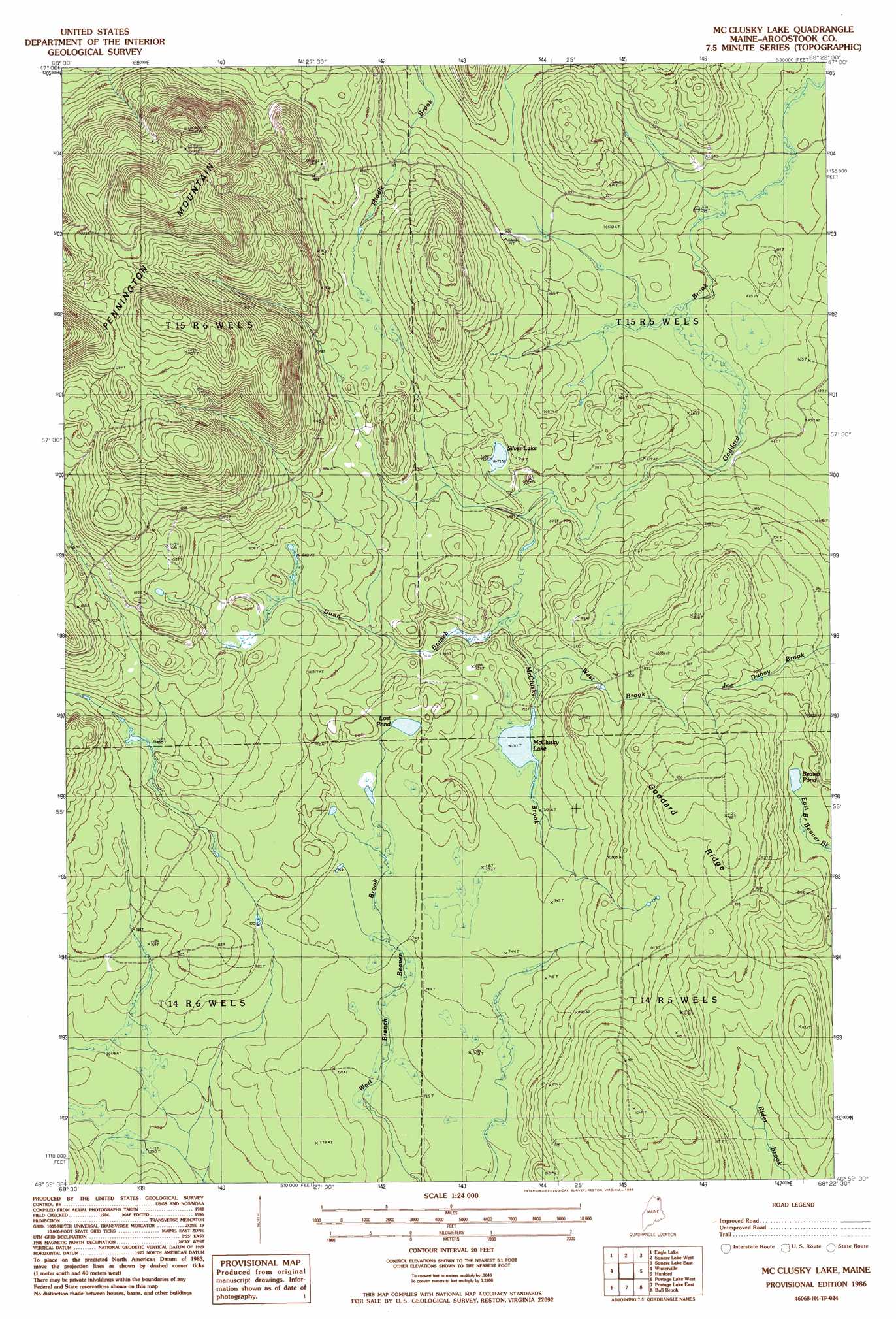
Mcclusky Lake Topo Map Maine
To zoom in, hover over the map of Mcclusky Lake
USGS Topo Quad 46068h4 - 1:24,000 scale
| Topo Map Name: | Mcclusky Lake |
| USGS Topo Quad ID: | 46068h4 |
| Print Size: | ca. 21 1/4" wide x 27" high |
| Southeast Coordinates: | 46.875° N latitude / 68.375° W longitude |
| Map Center Coordinates: | 46.9375° N latitude / 68.4375° W longitude |
| U.S. State: | ME |
| Filename: | o46068h4.jpg |
| Download Map JPG Image: | Mcclusky Lake topo map 1:24,000 scale |
| Map Type: | Topographic |
| Topo Series: | 7.5´ |
| Map Scale: | 1:24,000 |
| Source of Map Images: | United States Geological Survey (USGS) |
| Alternate Map Versions: |
Portage NW ME 1975, updated 1981 Download PDF Buy paper map Mc Clusky Lake ME 1986, updated 1986 Download PDF Buy paper map McClusky Lake ME 2011 Download PDF Buy paper map McClusky Lake ME 2014 Download PDF Buy paper map |
1:24,000 Topo Quads surrounding Mcclusky Lake
Wheelock |
Fort Kent South |
Daigle |
Saint Agatha |
Paulette Brook |
Wallacrass Lakes |
Eagle Lake |
Square Lake West |
Square Lake East |
Stockholm |
Island Pond |
Winterville |
Mcclusky Lake |
Hanford |
Mud Lake |
Carr Pond |
Portage Lake West |
Portage Lake East |
Bull Brook |
Washburn |
Greenlaw Pond |
Little Machias Lake |
Ashland |
York Ridge |
Mapleton |
> Back to 46068e1 at 1:100,000 scale
> Back to 46068a1 at 1:250,000 scale
> Back to U.S. Topo Maps home
Mcclusky Lake topo map: Gazetteer
Mcclusky Lake: Bridges
Old Chain Bridge elevation 189m 620′Mcclusky Lake: Lakes
Beaver Pond elevation 244m 800′Lost Pond elevation 236m 774′
McClusky Lake elevation 216m 708′
Silver Lake elevation 224m 734′
Mcclusky Lake: Ridges
Goddard Ridge elevation 294m 964′Mcclusky Lake: Streams
Dunn Branch elevation 212m 695′McClusky Brook elevation 224m 734′
West Brook elevation 213m 698′
Mcclusky Lake digital topo map on disk
Buy this Mcclusky Lake topo map showing relief, roads, GPS coordinates and other geographical features, as a high-resolution digital map file on DVD:
Maine, New Hampshire, Rhode Island & Eastern Massachusetts
Buy digital topo maps: Maine, New Hampshire, Rhode Island & Eastern Massachusetts