Island Pond Topo Map Maine
To zoom in, hover over the map of Island Pond
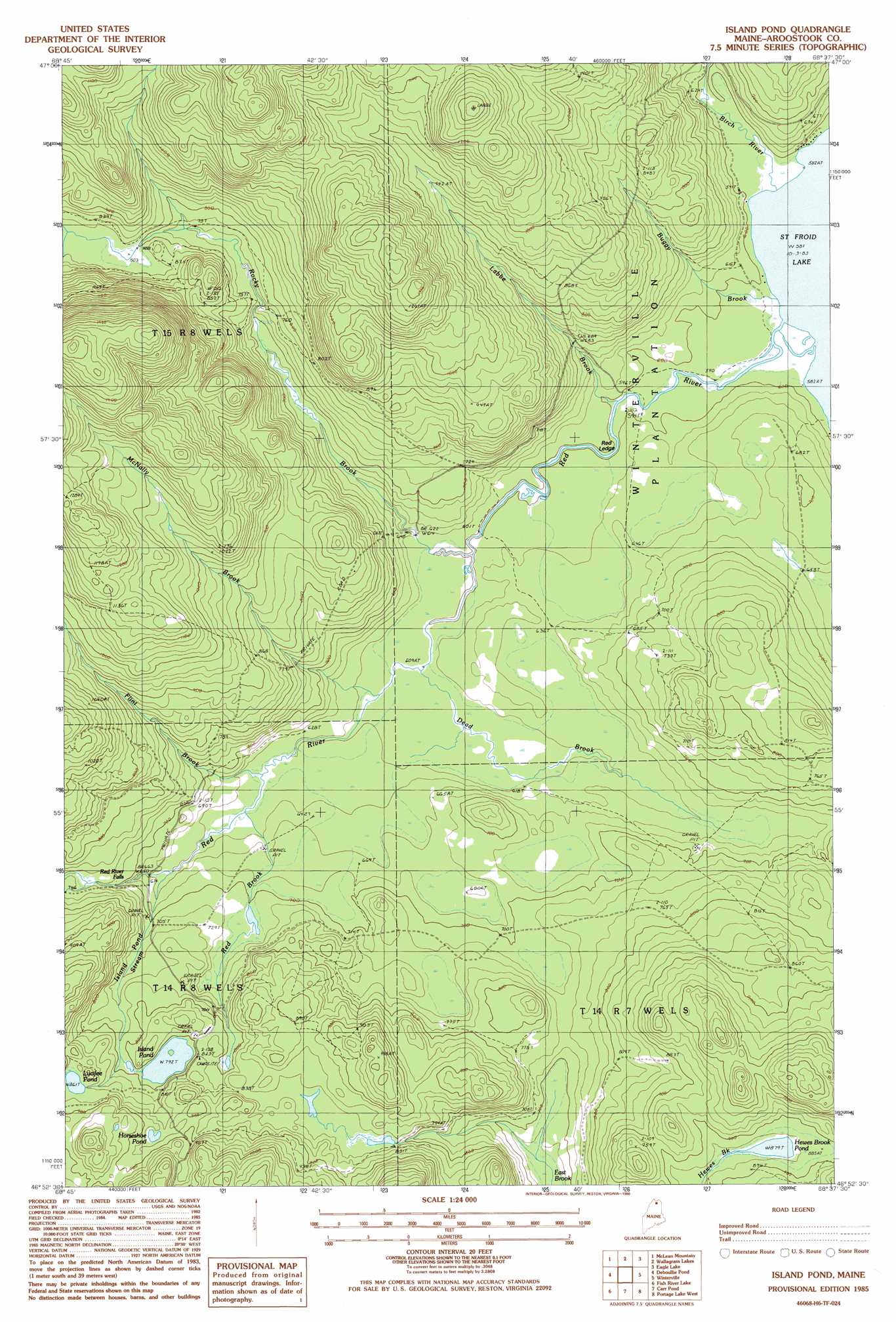
USGS Topo Quad 46068h6 - 1:24,000 scale
| Topo Map Name: | Island Pond |
| USGS Topo Quad ID: | 46068h6 |
| Print Size: | ca. 21 1/4" wide x 27" high |
| Southeast Coordinates: | 46.875° N latitude / 68.625° W longitude |
| Map Center Coordinates: | 46.9375° N latitude / 68.6875° W longitude |
| U.S. State: | ME |
| Filename: | o46068h6.jpg |
| Download Map JPG Image: | Island Pond topo map 1:24,000 scale |
| Map Type: | Topographic |
| Topo Series: | 7.5´ |
| Map Scale: | 1:24,000 |
| Source of Map Images: | United States Geological Survey (USGS) |
| Alternate Map Versions: |
Winterville NW ME 1975, updated 1981 Download PDF Buy paper map Island Pond ME 1985, updated 1986 Download PDF Buy paper map Island Pond ME 2011 Download PDF Buy paper map Island Pond ME 2014 Download PDF Buy paper map |
1:24,000 Topo Quads surrounding Island Pond
Saint Francis |
Saint John |
Wheelock |
Fort Kent South |
Daigle |
Second Lake |
Mclean Mountain |
Wallacrass Lakes |
Eagle Lake |
Square Lake West |
Gardner Pond |
Deboullie Pond |
Island Pond |
Winterville |
Mcclusky Lake |
Fish River Lake Sw |
Fish River Lake |
Carr Pond |
Portage Lake West |
Portage Lake East |
Farrar Pond |
Big Machias Lake |
Greenlaw Pond |
Little Machias Lake |
Ashland |
> Back to 46068e1 at 1:100,000 scale
> Back to 46068a1 at 1:250,000 scale
> Back to U.S. Topo Maps home
Island Pond topo map: Gazetteer
Island Pond: Benches
Red Ledge elevation 183m 600′Island Pond: Falls
Red River Falls elevation 195m 639′Island Pond: Lakes
Hewes Brook Pond elevation 268m 879′Horseshoe Pond elevation 269m 882′
Island Pond elevation 241m 790′
Lucifee Pond elevation 263m 862′
Island Pond: Reservoirs
Birch River Reservoir elevation 209m 685′Island Pond: Streams
Birch River elevation 177m 580′Buggy Brook elevation 177m 580′
Dead Brook elevation 186m 610′
Flint Brook elevation 192m 629′
Fourmile Brook elevation 226m 741′
Island Pond Stream elevation 199m 652′
Labbe Brook elevation 180m 590′
McNally Brook elevation 189m 620′
Red Brook elevation 195m 639′
Red River elevation 177m 580′
Rocky Brook elevation 183m 600′
Island Pond: Trails
Island Pond Trail elevation 293m 961′Island Pond digital topo map on disk
Buy this Island Pond topo map showing relief, roads, GPS coordinates and other geographical features, as a high-resolution digital map file on DVD:
Maine, New Hampshire, Rhode Island & Eastern Massachusetts
Buy digital topo maps: Maine, New Hampshire, Rhode Island & Eastern Massachusetts