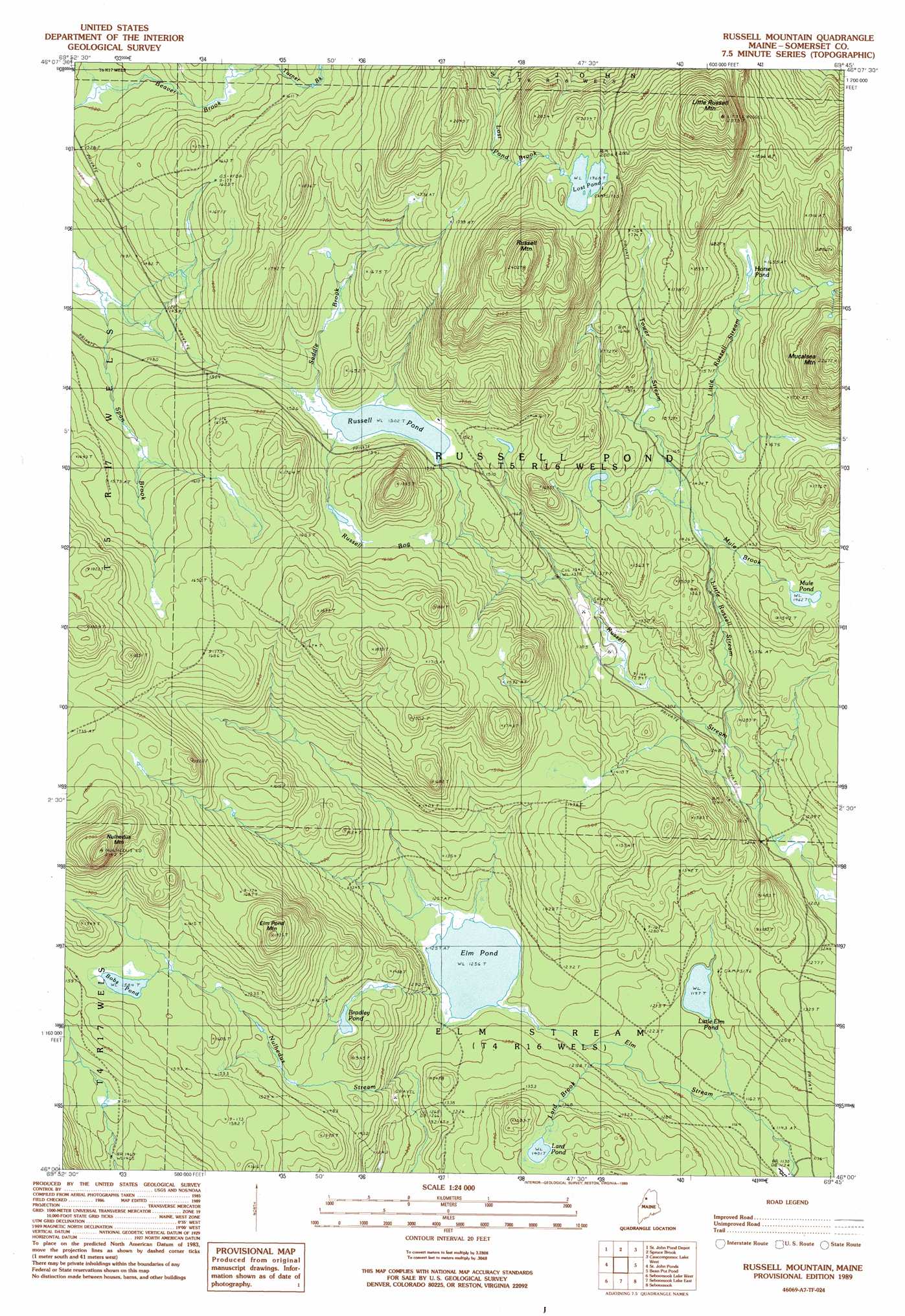
Russell Mountain Topo Map Maine
To zoom in, hover over the map of Russell Mountain
USGS Topo Quad 46069a7 - 1:24,000 scale
| Topo Map Name: | Russell Mountain |
| USGS Topo Quad ID: | 46069a7 |
| Print Size: | ca. 21 1/4" wide x 27" high |
| Southeast Coordinates: | 46° N latitude / 69.75° W longitude |
| Map Center Coordinates: | 46.0625° N latitude / 69.8125° W longitude |
| U.S. State: | ME |
| Filename: | o46069a7.jpg |
| Download Map JPG Image: | Russell Mountain topo map 1:24,000 scale |
| Map Type: | Topographic |
| Topo Series: | 7.5´ |
| Map Scale: | 1:24,000 |
| Source of Map Images: | United States Geological Survey (USGS) |
| Alternate Map Versions: |
Russell Mountain ME 1989, updated 1989 Download PDF Buy paper map Russell Mountain ME 2011 Download PDF Buy paper map Russell Mountain ME 2014 Download PDF Buy paper map |
1:24,000 Topo Quads surrounding Russell Mountain
Hardwood Mountain Se |
Baker Lake |
Turner Pond |
Wadleigh Pond |
Allagash Lake |
Hinckley Hill |
Saint John Pond Depot |
Spruce Brook |
Caucomgomoc Lake West |
Caucomgomoc Lake East |
Norris Brook |
Saint John Ponds |
Russell Mountain |
Bean Pot Pond |
Ragmuff Stream |
Foley Pond |
Seboomook Lake West |
Seboomook Lake East |
Seboomook |
Penobscot Farm |
Canada Falls Lake |
Tomhegan Pond |
Socatean Bay |
North East Carry |
Lobster Mountain |
> Back to 46069a1 at 1:100,000 scale
> Back to 46068a1 at 1:250,000 scale
> Back to U.S. Topo Maps home
Russell Mountain topo map: Gazetteer
Russell Mountain: Lakes
Bobs Pond elevation 483m 1584′Bradley Pond elevation 437m 1433′
Elm Pond elevation 383m 1256′
Horse Pond elevation 506m 1660′
Lard Pond elevation 427m 1400′
Little Elm Pond elevation 365m 1197′
Lost Pond elevation 600m 1968′
Mule Pond elevation 450m 1476′
Russell Pond elevation 458m 1502′
Russell Mountain: Streams
Lard Brook elevation 378m 1240′Little Russell Stream elevation 374m 1227′
Saddle Brook elevation 460m 1509′
Span Brook elevation 430m 1410′
Tower Stream elevation 436m 1430′
Turner Brook elevation 476m 1561′
Russell Mountain: Summits
Elm Pond Mountain elevation 581m 1906′Little Russell Mountain elevation 701m 2299′
Mucalsea Mountain elevation 690m 2263′
Nulhedus Mountain elevation 651m 2135′
Russell Mountain elevation 731m 2398′
Russell Mountain: Swamps
Russell Bog elevation 481m 1578′Russell Mountain digital topo map on disk
Buy this Russell Mountain topo map showing relief, roads, GPS coordinates and other geographical features, as a high-resolution digital map file on DVD:
Maine, New Hampshire, Rhode Island & Eastern Massachusetts
Buy digital topo maps: Maine, New Hampshire, Rhode Island & Eastern Massachusetts