Caucomgomoc Lake West Topo Map Maine
To zoom in, hover over the map of Caucomgomoc Lake West
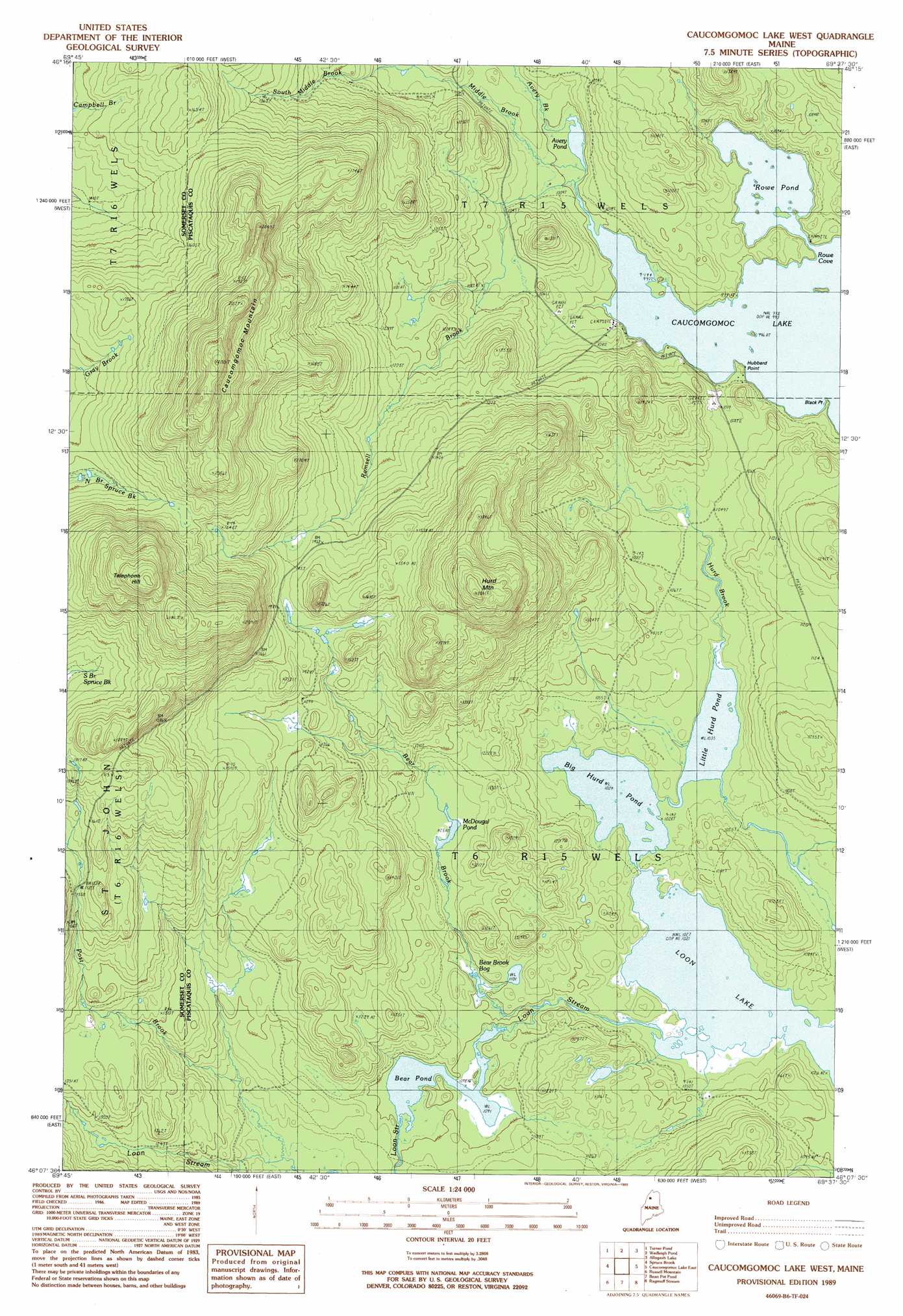
USGS Topo Quad 46069b6 - 1:24,000 scale
| Topo Map Name: | Caucomgomoc Lake West |
| USGS Topo Quad ID: | 46069b6 |
| Print Size: | ca. 21 1/4" wide x 27" high |
| Southeast Coordinates: | 46.125° N latitude / 69.625° W longitude |
| Map Center Coordinates: | 46.1875° N latitude / 69.6875° W longitude |
| U.S. State: | ME |
| Filename: | o46069b6.jpg |
| Download Map JPG Image: | Caucomgomoc Lake West topo map 1:24,000 scale |
| Map Type: | Topographic |
| Topo Series: | 7.5´ |
| Map Scale: | 1:24,000 |
| Source of Map Images: | United States Geological Survey (USGS) |
| Alternate Map Versions: |
Caucomgomoc Lake West ME 1989, updated 1989 Download PDF Buy paper map Caucomgomoc Lake West ME 2011 Download PDF Buy paper map Caucomgomoc Lake West ME 2014 Download PDF Buy paper map |
1:24,000 Topo Quads surrounding Caucomgomoc Lake West
Baker Lake Nw |
Doucie Brook |
Allagash Pond |
Upper Russell Pond |
Clarkson Pond |
Baker Lake |
Turner Pond |
Wadleigh Pond |
Allagash Lake |
Tramway |
Saint John Pond Depot |
Spruce Brook |
Caucomgomoc Lake West |
Caucomgomoc Lake East |
Longley Pond |
Saint John Ponds |
Russell Mountain |
Bean Pot Pond |
Ragmuff Stream |
Chesuncook |
Seboomook Lake West |
Seboomook Lake East |
Seboomook |
Penobscot Farm |
Pine Stream Flowage |
> Back to 46069a1 at 1:100,000 scale
> Back to 46068a1 at 1:250,000 scale
> Back to U.S. Topo Maps home
Caucomgomoc Lake West topo map: Gazetteer
Caucomgomoc Lake West: Capes
Black Point elevation 304m 997′Hubbard Point elevation 304m 997′
Caucomgomoc Lake West: Lakes
Avery Pond elevation 304m 997′Bear Brook Bog elevation 329m 1079′
Bear Pond elevation 332m 1089′
Big Hurd Pond elevation 312m 1023′
Little Hurd Pond elevation 315m 1033′
McDougal Pond elevation 344m 1128′
Rowe Pond elevation 304m 997′
Caucomgomoc Lake West: Streams
Avery Brook elevation 304m 997′Bear Brook elevation 328m 1076′
Hurd Brook elevation 317m 1040′
Middle Brook elevation 304m 997′
Post Brook elevation 339m 1112′
Ramsell Brook elevation 304m 997′
Caucomgomoc Lake West: Summits
Caucomgomoc Mountain elevation 701m 2299′Hurd Mountain elevation 608m 1994′
Telephone Hill elevation 700m 2296′
Caucomgomoc Lake West digital topo map on disk
Buy this Caucomgomoc Lake West topo map showing relief, roads, GPS coordinates and other geographical features, as a high-resolution digital map file on DVD:
Maine, New Hampshire, Rhode Island & Eastern Massachusetts
Buy digital topo maps: Maine, New Hampshire, Rhode Island & Eastern Massachusetts