Beetle Mountain Topo Map Maine
To zoom in, hover over the map of Beetle Mountain
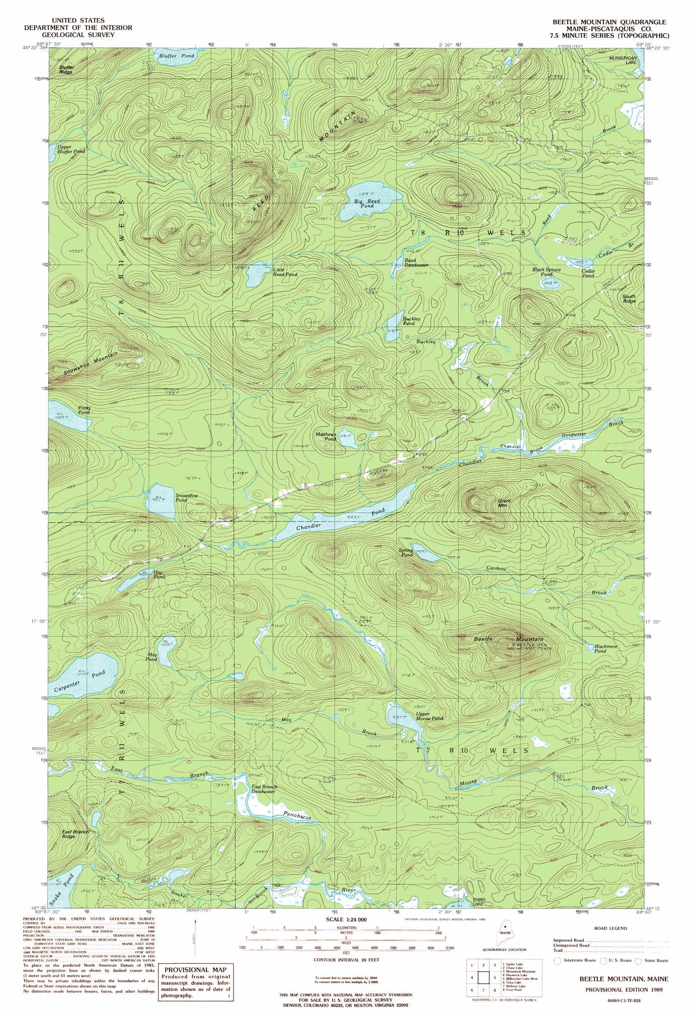
USGS Topo Quad 46069c1 - 1:24,000 scale
| Topo Map Name: | Beetle Mountain |
| USGS Topo Quad ID: | 46069c1 |
| Print Size: | ca. 21 1/4" wide x 27" high |
| Southeast Coordinates: | 46.25° N latitude / 69° W longitude |
| Map Center Coordinates: | 46.3125° N latitude / 69.0625° W longitude |
| U.S. State: | ME |
| Filename: | o46069c1.jpg |
| Download Map JPG Image: | Beetle Mountain topo map 1:24,000 scale |
| Map Type: | Topographic |
| Topo Series: | 7.5´ |
| Map Scale: | 1:24,000 |
| Source of Map Images: | United States Geological Survey (USGS) |
| Alternate Map Versions: |
Beetle Mountain ME 1989, updated 1989 Download PDF Buy paper map Beetle Mountain ME 2011 Download PDF Buy paper map Beetle Mountain ME 2014 Download PDF Buy paper map |
1:24,000 Topo Quads surrounding Beetle Mountain
Umaskis Lake East |
Third Musquacook Lake |
Fifth Musquacook Lake |
Mooseleuk Lake |
Round Mountain |
Churchill Lake |
Spider Lake |
Chase Lake |
Mooseleuk Mountain |
Middle Brook Mountain |
Soper Mountain |
Haymock Lake |
Beetle Mountain |
Millinocket Lake West |
Millinocket Lake East |
Mud Pond |
Telos Lake |
Webster Lake |
Frost Pond |
Trout Brook Mountain |
Cuxabexis Lake |
Telos Brook |
Nesowad Nehunk Lake |
Wassataquoik Lake |
The Traveler |
> Back to 46069a1 at 1:100,000 scale
> Back to 46068a1 at 1:250,000 scale
> Back to U.S. Topo Maps home
Beetle Mountain topo map: Gazetteer
Beetle Mountain: Lakes
Big Reed Pond elevation 345m 1131′Black Spruce Pond elevation 306m 1003′
Blackmore Pond elevation 277m 908′
Bluffer Pond elevation 345m 1131′
Buckley Pond elevation 327m 1072′
Carpenter Pond elevation 318m 1043′
Cedar Pond elevation 309m 1013′
Chandler Brook Deadwater elevation 267m 875′
Chandler Pond elevation 273m 895′
East Branch Deadwater elevation 258m 846′
Hay Pond elevation 288m 944′
Little Reed Pond elevation 382m 1253′
Matthews Pond elevation 330m 1082′
May Pond elevation 306m 1003′
Pretty Pond elevation 308m 1010′
Reed Deadwater elevation 322m 1056′
Snowshoe Pond elevation 283m 928′
Spring Pond elevation 301m 987′
Upper Bluffer Pond elevation 385m 1263′
Upper Moose Pond elevation 255m 836′
Beetle Mountain: Streams
Buckley Brook elevation 268m 879′May Brook elevation 255m 836′
Reed Brook elevation 247m 810′
Snake Brook elevation 242m 793′
Beetle Mountain: Summits
Beetle Mountain elevation 503m 1650′Grant Mountain elevation 452m 1482′
Reed Mountain elevation 523m 1715′
Snowshoe Mountain elevation 466m 1528′
Beetle Mountain digital topo map on disk
Buy this Beetle Mountain topo map showing relief, roads, GPS coordinates and other geographical features, as a high-resolution digital map file on DVD:
Maine, New Hampshire, Rhode Island & Eastern Massachusetts
Buy digital topo maps: Maine, New Hampshire, Rhode Island & Eastern Massachusetts