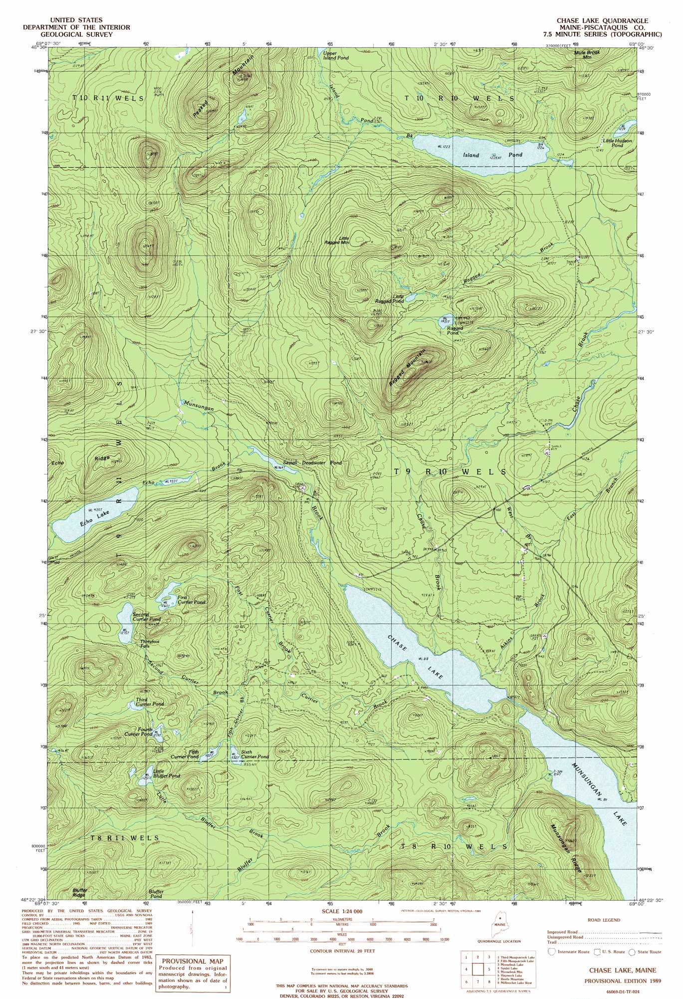
Chase Lake Topo Map Maine
To zoom in, hover over the map of Chase Lake
USGS Topo Quad 46069d1 - 1:24,000 scale
| Topo Map Name: | Chase Lake |
| USGS Topo Quad ID: | 46069d1 |
| Print Size: | ca. 21 1/4" wide x 27" high |
| Southeast Coordinates: | 46.375° N latitude / 69° W longitude |
| Map Center Coordinates: | 46.4375° N latitude / 69.0625° W longitude |
| U.S. State: | ME |
| Filename: | o46069d1.jpg |
| Download Map JPG Image: | Chase Lake topo map 1:24,000 scale |
| Map Type: | Topographic |
| Topo Series: | 7.5´ |
| Map Scale: | 1:24,000 |
| Source of Map Images: | United States Geological Survey (USGS) |
| Alternate Map Versions: |
Chase Lake ME 1989, updated 1989 Download PDF Buy paper map Chase Lake ME 2011 Download PDF Buy paper map Chase Lake ME 2014 Download PDF Buy paper map |
1:24,000 Topo Quads surrounding Chase Lake
Cunliffe Islands |
First Musquacook Lake |
Upper Mcnally Pond |
Farrar Pond |
Big Machias Lake |
Umaskis Lake East |
Third Musquacook Lake |
Fifth Musquacook Lake |
Mooseleuk Lake |
Round Mountain |
Churchill Lake |
Spider Lake |
Chase Lake |
Mooseleuk Mountain |
Middle Brook Mountain |
Soper Mountain |
Haymock Lake |
Beetle Mountain |
Millinocket Lake West |
Millinocket Lake East |
Mud Pond |
Telos Lake |
Webster Lake |
Frost Pond |
Trout Brook Mountain |
> Back to 46069a1 at 1:100,000 scale
> Back to 46068a1 at 1:250,000 scale
> Back to U.S. Topo Maps home
Chase Lake topo map: Gazetteer
Chase Lake: Falls
Thirtyfoot Falls elevation 379m 1243′Chase Lake: Lakes
Chase Lake elevation 249m 816′Echo Lake elevation 285m 935′
Fifth Currier Pond elevation 345m 1131′
First Currier Pond elevation 385m 1263′
Fourth Currier Pond elevation 390m 1279′
Island Pond elevation 374m 1227′
Little Bluffer Pond elevation 381m 1250′
Little Hudson Pond elevation 375m 1230′
Little Ragged Pond elevation 456m 1496′
Ragged Pond elevation 442m 1450′
Second Currier Pond elevation 388m 1272′
Sewall Deadwater Pond elevation 263m 862′
Sixth Currier Pond elevation 345m 1131′
Third Currier Pond elevation 398m 1305′
Chase Lake: Ridges
Echo Ridge elevation 360m 1181′Munsungan Ridge elevation 333m 1092′
Chase Lake: Streams
Atkins Brook elevation 250m 820′Bluffer Brook elevation 247m 810′
Chase Brook elevation 249m 816′
Currier Brook elevation 249m 816′
East Branch Atkins Brook elevation 296m 971′
Echo Brook elevation 263m 862′
Fifth Currier Brook elevation 297m 974′
First Currier Brook elevation 296m 971′
Island Pond Brook elevation 374m 1227′
Little Bluffer Brook elevation 316m 1036′
Munsungan Brook elevation 249m 816′
North Branch Echo Brook elevation 285m 935′
Norway Brook elevation 250m 820′
Ragged Brook elevation 348m 1141′
Second Currier Brook elevation 297m 974′
South Branch Echo Brook elevation 285m 935′
West Branch Atkins Brook elevation 295m 967′
Chase Lake: Summits
Little Ragged Mountain elevation 554m 1817′Ragged Mountain elevation 580m 1902′
Chase Lake digital topo map on disk
Buy this Chase Lake topo map showing relief, roads, GPS coordinates and other geographical features, as a high-resolution digital map file on DVD:
Maine, New Hampshire, Rhode Island & Eastern Massachusetts
Buy digital topo maps: Maine, New Hampshire, Rhode Island & Eastern Massachusetts