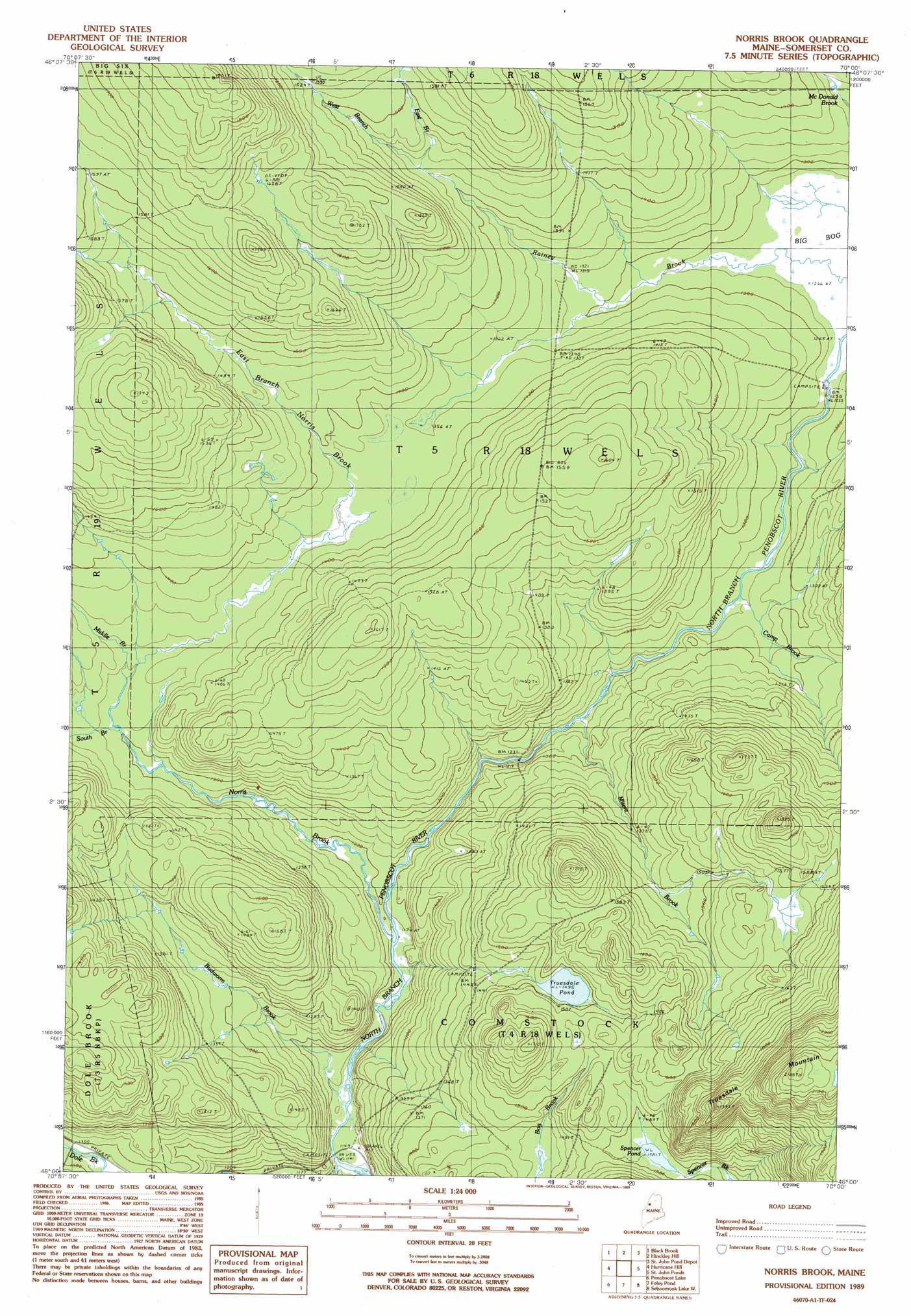
Norris Brook Topo Map Maine
To zoom in, hover over the map of Norris Brook
USGS Topo Quad 46070a1 - 1:24,000 scale
| Topo Map Name: | Norris Brook |
| USGS Topo Quad ID: | 46070a1 |
| Print Size: | ca. 21 1/4" wide x 27" high |
| Southeast Coordinates: | 46° N latitude / 70° W longitude |
| Map Center Coordinates: | 46.0625° N latitude / 70.0625° W longitude |
| U.S. State: | ME |
| Filename: | o46070a1.jpg |
| Download Map JPG Image: | Norris Brook topo map 1:24,000 scale |
| Map Type: | Topographic |
| Topo Series: | 7.5´ |
| Map Scale: | 1:24,000 |
| Source of Map Images: | United States Geological Survey (USGS) |
| Alternate Map Versions: |
Norris Brook ME 1989, updated 1989 Download PDF Buy paper map Norris Brook ME 2011 Download PDF Buy paper map Norris Brook ME 2014 Download PDF Buy paper map |
1:24,000 Topo Quads surrounding Norris Brook
Hardwood Mountain Sw |
Hardwood Mountain Se |
Baker Lake |
Turner Pond |
|
Saint Zacharie North |
Black Brook |
Hinckley Hill |
Saint John Pond Depot |
Spruce Brook |
Saint Zacharie South |
Hurricane Hill |
Norris Brook |
Saint John Ponds |
Russell Mountain |
Lac Portage |
Penobscot Lake |
Foley Pond |
Seboomook Lake West |
Seboomook Lake East |
Campbell Brook |
Boundary Bald Mountain |
Canada Falls Lake |
Tomhegan Pond |
Socatean Bay |
> Back to 46070a1 at 1:100,000 scale
> Back to 46070a1 at 1:250,000 scale
> Back to U.S. Topo Maps home
Norris Brook topo map: Gazetteer
Norris Brook: Lakes
Spencer Pond elevation 451m 1479′Truesdale Pond elevation 456m 1496′
Norris Brook: Reservoirs
Big Bog elevation 384m 1259′Norris Brook: Streams
Budworm Brook elevation 351m 1151′Camp Brook elevation 383m 1256′
Dole Brook elevation 347m 1138′
East Branch Norris Brook elevation 402m 1318′
East Branch Rainey Brook elevation 435m 1427′
Middle Branch Norris Brook elevation 401m 1315′
Misere Brook elevation 378m 1240′
Norris Brook elevation 359m 1177′
Rainey Brook elevation 388m 1272′
South Branch Norris Brook elevation 397m 1302′
West Branch Rainey Brook elevation 435m 1427′
Norris Brook: Summits
Truesdale Mountain elevation 658m 2158′Norris Brook digital topo map on disk
Buy this Norris Brook topo map showing relief, roads, GPS coordinates and other geographical features, as a high-resolution digital map file on DVD:
Maine, New Hampshire, Rhode Island & Eastern Massachusetts
Buy digital topo maps: Maine, New Hampshire, Rhode Island & Eastern Massachusetts