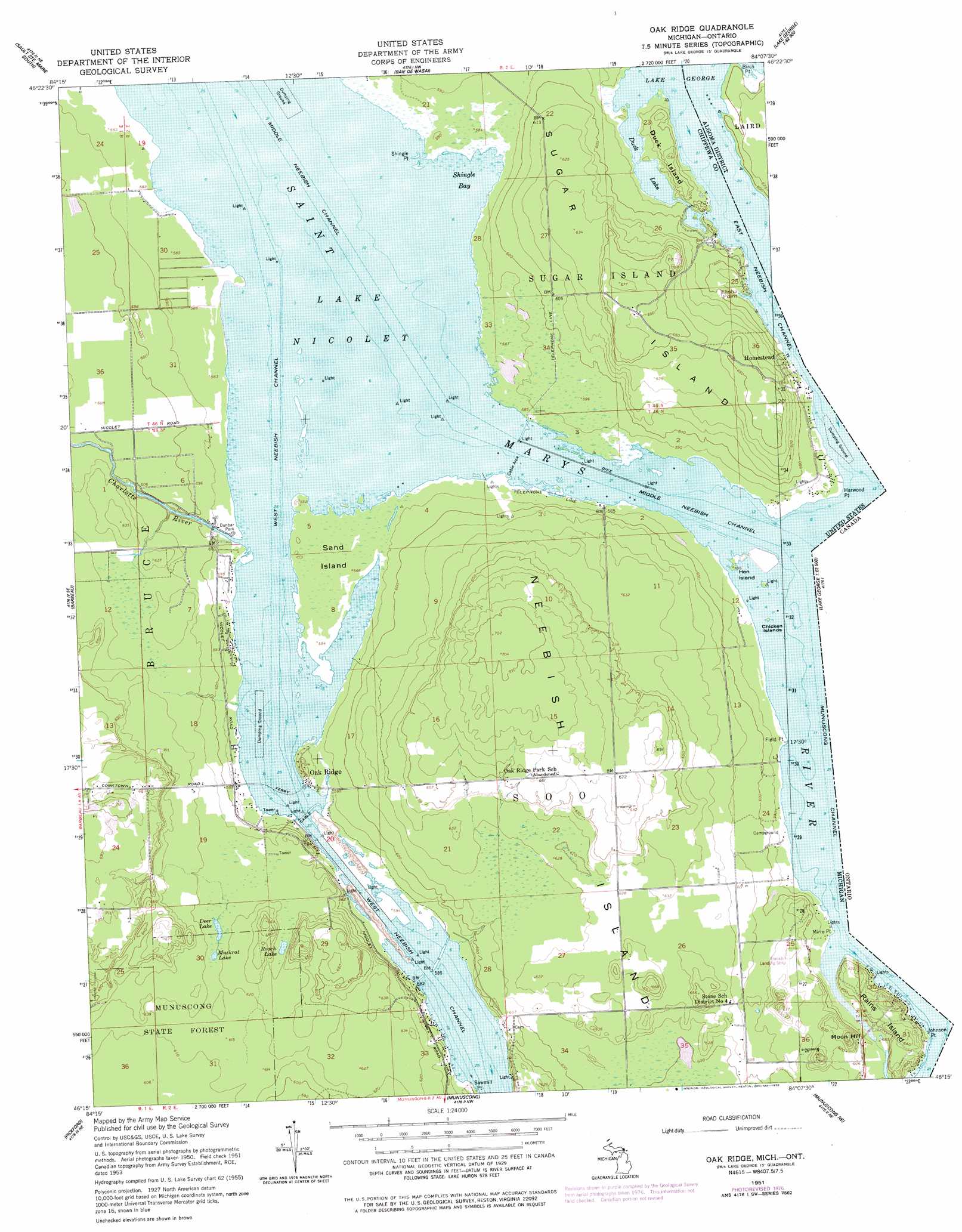
Oak Ridge Topo Map Michigan
To zoom in, hover over the map of Oak Ridge
USGS Topo Quad 46084c2 - 1:24,000 scale
| Topo Map Name: | Oak Ridge |
| USGS Topo Quad ID: | 46084c2 |
| Print Size: | ca. 21 1/4" wide x 27" high |
| Southeast Coordinates: | 46.25° N latitude / 84.125° W longitude |
| Map Center Coordinates: | 46.3125° N latitude / 84.1875° W longitude |
| U.S. State: | MI |
| Filename: | o46084c2.jpg |
| Download Map JPG Image: | Oak Ridge topo map 1:24,000 scale |
| Map Type: | Topographic |
| Topo Series: | 7.5´ |
| Map Scale: | 1:24,000 |
| Source of Map Images: | United States Geological Survey (USGS) |
| Alternate Map Versions: |
Oak Ridge MI 1951, updated 1958 Download PDF Buy paper map Oak Ridge MI 1951, updated 1978 Download PDF Buy paper map Oak Ridge MI 2011 Download PDF Buy paper map Oak Ridge MI 2014 Download PDF Buy paper map Oak Ridge MI 2017 Download PDF Buy paper map |
1:24,000 Topo Quads surrounding Oak Ridge
Payment |
||||
Shallows |
Sault Sainte Marie South |
Baie De Wasai |
||
Dafter |
Barbeau |
Oak Ridge |
||
Pickford Nw |
Pickford |
Munuscong |
Munuscong Ne |
|
Hessel |
Pickford Se |
Stalwart |
Goetzville |
Lime Island |
> Back to 46084a1 at 1:100,000 scale
> Back to 46084a1 at 1:250,000 scale
> Back to U.S. Topo Maps home
Oak Ridge topo map: Gazetteer
Oak Ridge: Airports
Franklin Landing Strip elevation 188m 616′Franklins Airport elevation 188m 616′
Oak Ridge: Bays
Shingle Bay elevation 177m 580′Oak Ridge: Capes
Elisha Point elevation 177m 580′Field Point elevation 177m 580′
Indian Point elevation 181m 593′
Shingle Point elevation 179m 587′
Oak Ridge: Channels
East Neebish Channel elevation 177m 580′Middle Neebish Channel elevation 177m 580′
West Neebish Channel elevation 177m 580′
Oak Ridge: Islands
Chicken Islands elevation 177m 580′Duck Island elevation 188m 616′
Hen Island elevation 180m 590′
Neebish Island elevation 200m 656′
Sand Island elevation 178m 583′
Oak Ridge: Lakes
Deer Lake elevation 188m 616′Duck Lake elevation 177m 580′
Muskrat Lake elevation 188m 616′
Roach Lake elevation 187m 613′
Oak Ridge: Parks
Dunbar Park elevation 179m 587′Oak Ridge: Populated Places
Oak Ridge elevation 180m 590′Oak Ridge: Post Offices
Oak Ridge Park Post Office (historical) elevation 180m 590′Oak Ridge: Streams
Charlotte River elevation 177m 580′Oak Ridge digital topo map on disk
Buy this Oak Ridge topo map showing relief, roads, GPS coordinates and other geographical features, as a high-resolution digital map file on DVD: