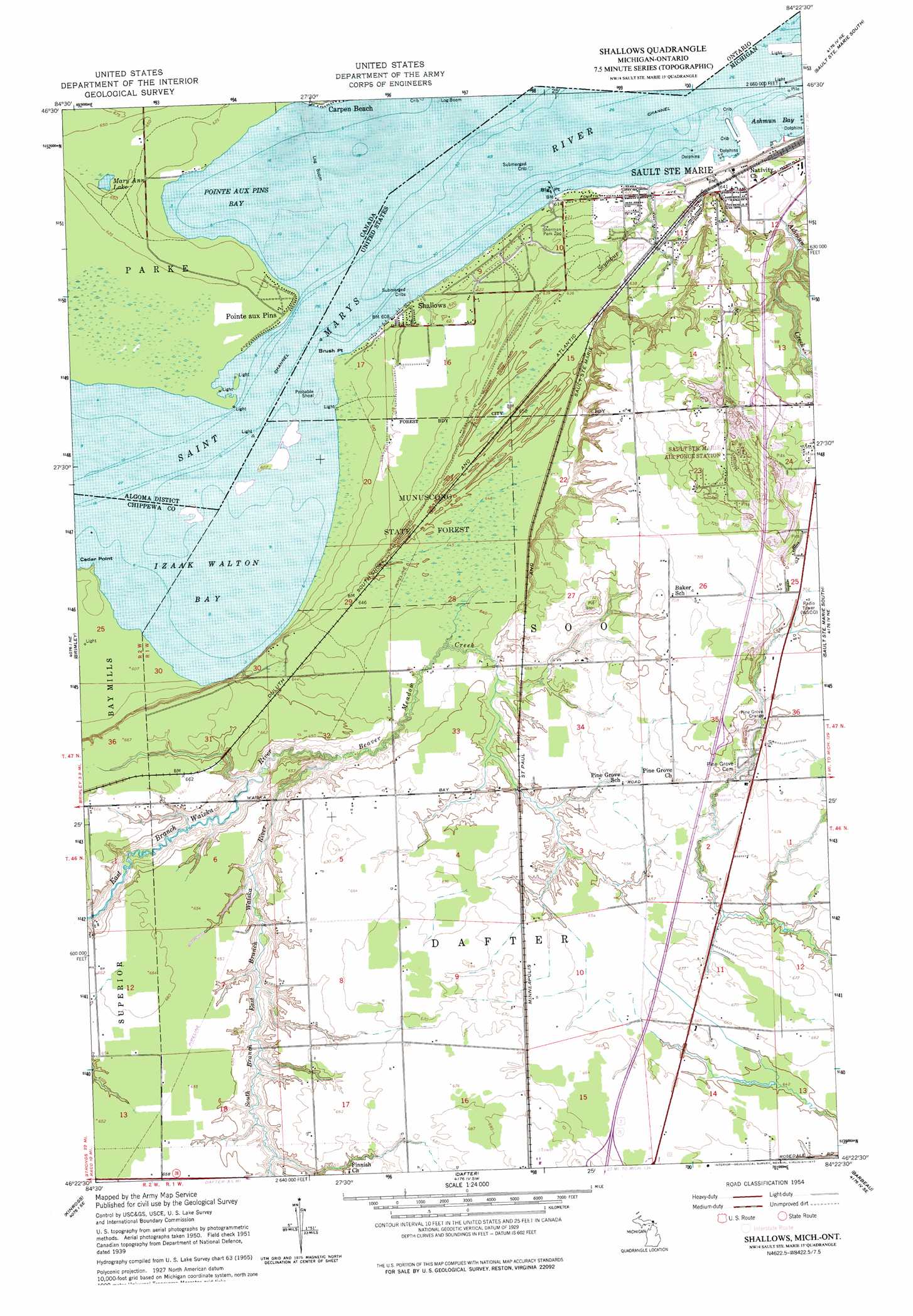
Shallows Topo Map Michigan
To zoom in, hover over the map of Shallows
USGS Topo Quad 46084d4 - 1:24,000 scale
| Topo Map Name: | Shallows |
| USGS Topo Quad ID: | 46084d4 |
| Print Size: | ca. 21 1/4" wide x 27" high |
| Southeast Coordinates: | 46.375° N latitude / 84.375° W longitude |
| Map Center Coordinates: | 46.4375° N latitude / 84.4375° W longitude |
| U.S. State: | MI |
| Filename: | o46084d4.jpg |
| Download Map JPG Image: | Shallows topo map 1:24,000 scale |
| Map Type: | Topographic |
| Topo Series: | 7.5´ |
| Map Scale: | 1:24,000 |
| Source of Map Images: | United States Geological Survey (USGS) |
| Alternate Map Versions: |
Shallows MI 1951, updated 1958 Download PDF Buy paper map Shallows MI 1951, updated 1977 Download PDF Buy paper map Shallows MI 2011 Download PDF Buy paper map Shallows MI 2014 Download PDF Buy paper map Shallows MI 2017 Download PDF Buy paper map |
1:24,000 Topo Quads surrounding Shallows
Payment |
||||
Dollar Settlement |
Brimley |
Shallows |
Sault Sainte Marie South |
Baie De Wasai |
Raco |
Kinross |
Dafter |
Barbeau |
Oak Ridge |
Fibre |
Rudyard |
Pickford Nw |
Pickford |
Munuscong |
> Back to 46084a1 at 1:100,000 scale
> Back to 46084a1 at 1:250,000 scale
> Back to U.S. Topo Maps home
Shallows topo map: Gazetteer
Shallows: Bays
Ashmun Bay elevation 184m 603′Izaak Walton Bay elevation 184m 603′
Shallows: Capes
Big Point elevation 186m 610′Brush Point elevation 184m 603′
Cedar Point elevation 184m 603′
Shallows: Crossings
Interchange 392 elevation 219m 718′Shallows: Parks
Sault Sainte Marie Historical Marker elevation 214m 702′Sherman Park elevation 189m 620′
Shallows: Populated Places
L and M Trailer Park elevation 192m 629′Shallows elevation 187m 613′
Shallows: Streams
Beaver Meadow Creek elevation 186m 610′Seymour Creek elevation 186m 610′
South Branch East Branch Waiska River elevation 186m 610′
Shallows digital topo map on disk
Buy this Shallows topo map showing relief, roads, GPS coordinates and other geographical features, as a high-resolution digital map file on DVD: