Mcnearney Lake Topo Map Michigan
To zoom in, hover over the map of Mcnearney Lake
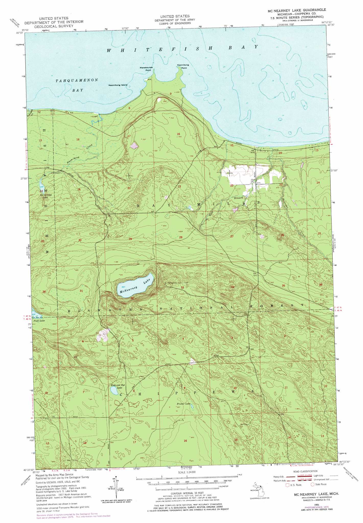
USGS Topo Quad 46084d8 - 1:24,000 scale
| Topo Map Name: | Mcnearney Lake |
| USGS Topo Quad ID: | 46084d8 |
| Print Size: | ca. 21 1/4" wide x 27" high |
| Southeast Coordinates: | 46.375° N latitude / 84.875° W longitude |
| Map Center Coordinates: | 46.4375° N latitude / 84.9375° W longitude |
| U.S. State: | MI |
| Filename: | o46084d8.jpg |
| Download Map JPG Image: | Mcnearney Lake topo map 1:24,000 scale |
| Map Type: | Topographic |
| Topo Series: | 7.5´ |
| Map Scale: | 1:24,000 |
| Source of Map Images: | United States Geological Survey (USGS) |
| Alternate Map Versions: |
McNearney Lake MI 1951, updated 1955 Download PDF Buy paper map McNearney Lake MI 1951, updated 1971 Download PDF Buy paper map McNearney Lake MI 1951, updated 1977 Download PDF Buy paper map McNearney Lake MI 2011 Download PDF Buy paper map McNearney Lake MI 2014 Download PDF Buy paper map McNearney Lake MI 2017 Download PDF Buy paper map |
| FStopo: | US Forest Service topo McNearney Lake is available: Download FStopo PDF Download FStopo TIF |
1:24,000 Topo Quads surrounding Mcnearney Lake
Sheephead Lake |
Shelldrake |
Whitefish Point |
||
Timberlost |
Emerson |
|||
Big Beaver Creek |
Piatt Lake |
Mcnearney Lake |
Pendills Lake |
Dollar Settlement |
Hulbert |
Eckerman |
Strongs |
Sullivan Creek |
Raco |
Rexton |
Trout Lake |
Ozark |
Ozark Ne |
Fibre |
> Back to 46084a1 at 1:100,000 scale
> Back to 46084a1 at 1:250,000 scale
> Back to U.S. Topo Maps home
Mcnearney Lake topo map: Gazetteer
Mcnearney Lake: Capes
Menekaunee Point elevation 183m 600′Naomikong Point elevation 183m 600′
Mcnearney Lake: Islands
Naomikong Island elevation 183m 600′Mcnearney Lake: Lakes
McNearney Lake elevation 264m 866′Naomikong Lake elevation 194m 636′
Naomikong Pond elevation 216m 708′
Peck and Rye Lake elevation 276m 905′
Proctor Lake elevation 268m 879′
Mcnearney Lake: Streams
Ankodosh Creek elevation 184m 603′Bergman Creek elevation 183m 600′
Halfaday Creek elevation 183m 600′
Mill Creek elevation 184m 603′
Naomikong Creek elevation 184m 603′
West Branch Halfaday Creek elevation 186m 610′
Mcnearney Lake digital topo map on disk
Buy this Mcnearney Lake topo map showing relief, roads, GPS coordinates and other geographical features, as a high-resolution digital map file on DVD: