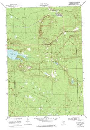
Eckerman Topo Map Michigan
To zoom in, hover over the map of Eckerman
USGS Topo Quad 46085c1 - 1:24,000 scale
| Topo Map Name: | Eckerman |
| USGS Topo Quad ID: | 46085c1 |
| Print Size: | ca. 21 1/4" wide x 27" high |
| Southeast Coordinates: | 46.25° N latitude / 85° W longitude |
| Map Center Coordinates: | 46.3125° N latitude / 85.0625° W longitude |
| U.S. State: | MI |
| Filename: | o46085c1.jpg |
| Download Map JPG Image: | Eckerman topo map 1:24,000 scale |
| Map Type: | Topographic |
| Topo Series: | 7.5´ |
| Map Scale: | 1:24,000 |
| Source of Map Images: | United States Geological Survey (USGS) |
| Alternate Map Versions: |
Eckerman MI 1951, updated 1955 Download PDF Buy paper map Eckerman MI 1951, updated 1977 Download PDF Buy paper map Eckerman MI 2011 Download PDF Buy paper map Eckerman MI 2014 Download PDF Buy paper map Eckerman MI 2017 Download PDF Buy paper map |
| FStopo: | US Forest Service topo Eckerman is available: Download FStopo PDF Download FStopo TIF |
1:24,000 Topo Quads surrounding Eckerman
> Back to 46085a1 at 1:100,000 scale
> Back to 46084a1 at 1:250,000 scale
> Back to U.S. Topo Maps home
Eckerman topo map: Gazetteer
Eckerman: Airports
O Conner Airstrip elevation 229m 751′Eckerman: Lakes
Deerfoot Lake elevation 267m 875′Hulbert Lake elevation 245m 803′
Little Mud Lake elevation 245m 803′
Mud Lake elevation 245m 803′
Pardy Pond elevation 261m 856′
Riley Lake elevation 225m 738′
Williams Lake elevation 261m 856′
Eckerman: Populated Places
Eckerman elevation 236m 774′Eckerman Corner elevation 263m 862′
Eckerman Corner Lookout Tower elevation 291m 954′
Seewhy elevation 220m 721′
Eckerman: Post Offices
Eckerman Post Office elevation 236m 774′Seewhy Post Office (historical) elevation 220m 721′
Eckerman: Streams
Creek Number Fourteen elevation 219m 718′Grants Creek elevation 219m 718′
Naugle Creek elevation 231m 757′
Eckerman digital topo map on disk
Buy this Eckerman topo map showing relief, roads, GPS coordinates and other geographical features, as a high-resolution digital map file on DVD:


