Muskallonge Lake East Topo Map Michigan
To zoom in, hover over the map of Muskallonge Lake East
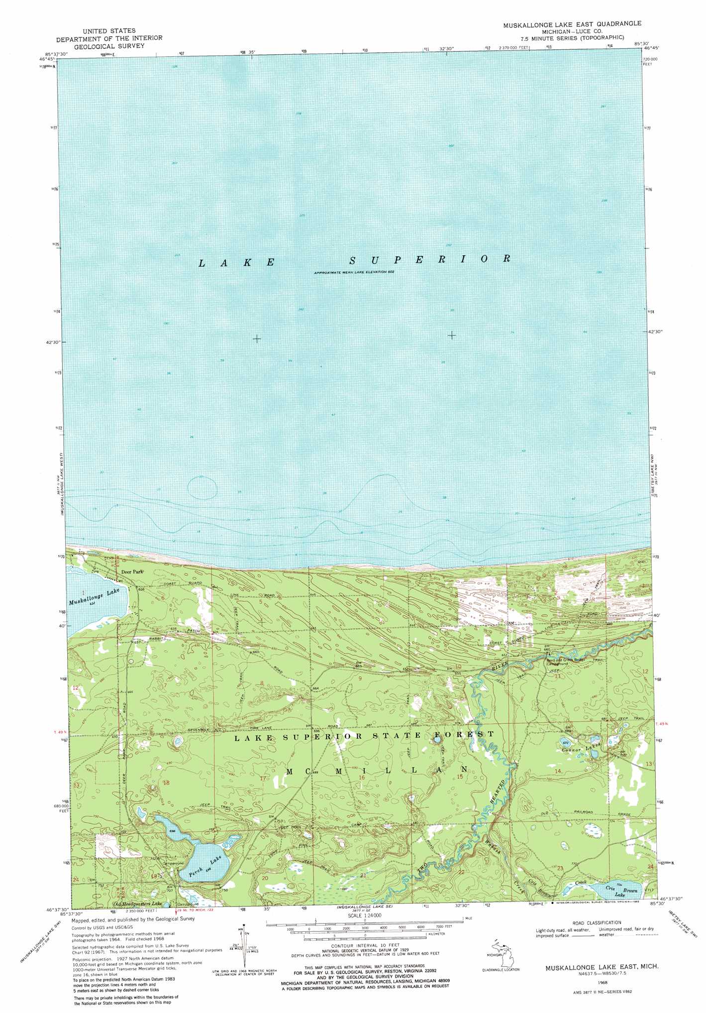
USGS Topo Quad 46085f5 - 1:24,000 scale
| Topo Map Name: | Muskallonge Lake East |
| USGS Topo Quad ID: | 46085f5 |
| Print Size: | ca. 21 1/4" wide x 27" high |
| Southeast Coordinates: | 46.625° N latitude / 85.5° W longitude |
| Map Center Coordinates: | 46.6875° N latitude / 85.5625° W longitude |
| U.S. State: | MI |
| Filename: | o46085f5.jpg |
| Download Map JPG Image: | Muskallonge Lake East topo map 1:24,000 scale |
| Map Type: | Topographic |
| Topo Series: | 7.5´ |
| Map Scale: | 1:24,000 |
| Source of Map Images: | United States Geological Survey (USGS) |
| Alternate Map Versions: |
Muskallonge Lake East MI 1968, updated 1970 Download PDF Buy paper map Muskallonge Lake East MI 1968, updated 1982 Download PDF Buy paper map Muskallonge Lake East MI 2011 Download PDF Buy paper map Muskallonge Lake East MI 2014 Download PDF Buy paper map Muskallonge Lake East MI 2017 Download PDF Buy paper map |
1:24,000 Topo Quads surrounding Muskallonge Lake East
Grand Marais Ne |
Muskallonge Lake West |
Muskallonge Lake East |
Betsy Lake Nw |
Betsy Lake North |
Grand Marais Se |
Muskallonge Lake Sw |
Muskallonge Lake Se |
Betsy Lake Sw |
Betsy Lake South |
Tahquamenon Lakes |
Buckeye Lake |
Auger Lake |
Roy Lake |
Gimlet Creek |
> Back to 46085e1 at 1:100,000 scale
> Back to 46084a1 at 1:250,000 scale
> Back to U.S. Topo Maps home
Muskallonge Lake East topo map: Gazetteer
Muskallonge Lake East: Forests
Lake Superior State Forest elevation 210m 688′Muskallonge Lake East: Lakes
Connor Lakes elevation 204m 669′Cris Brown Lake elevation 215m 705′
Perch Lake elevation 213m 698′
Muskallonge Lake East: Populated Places
Deer Park elevation 195m 639′Muskallonge Lake East: Post Offices
Deerpark Post Office (historical) elevation 195m 639′Muskallonge Lake East: Streams
Cris Brown Creek elevation 208m 682′Wabash Creek elevation 198m 649′
Muskallonge Lake East digital topo map on disk
Buy this Muskallonge Lake East topo map showing relief, roads, GPS coordinates and other geographical features, as a high-resolution digital map file on DVD: