Lake Stella Topo Map Michigan
To zoom in, hover over the map of Lake Stella
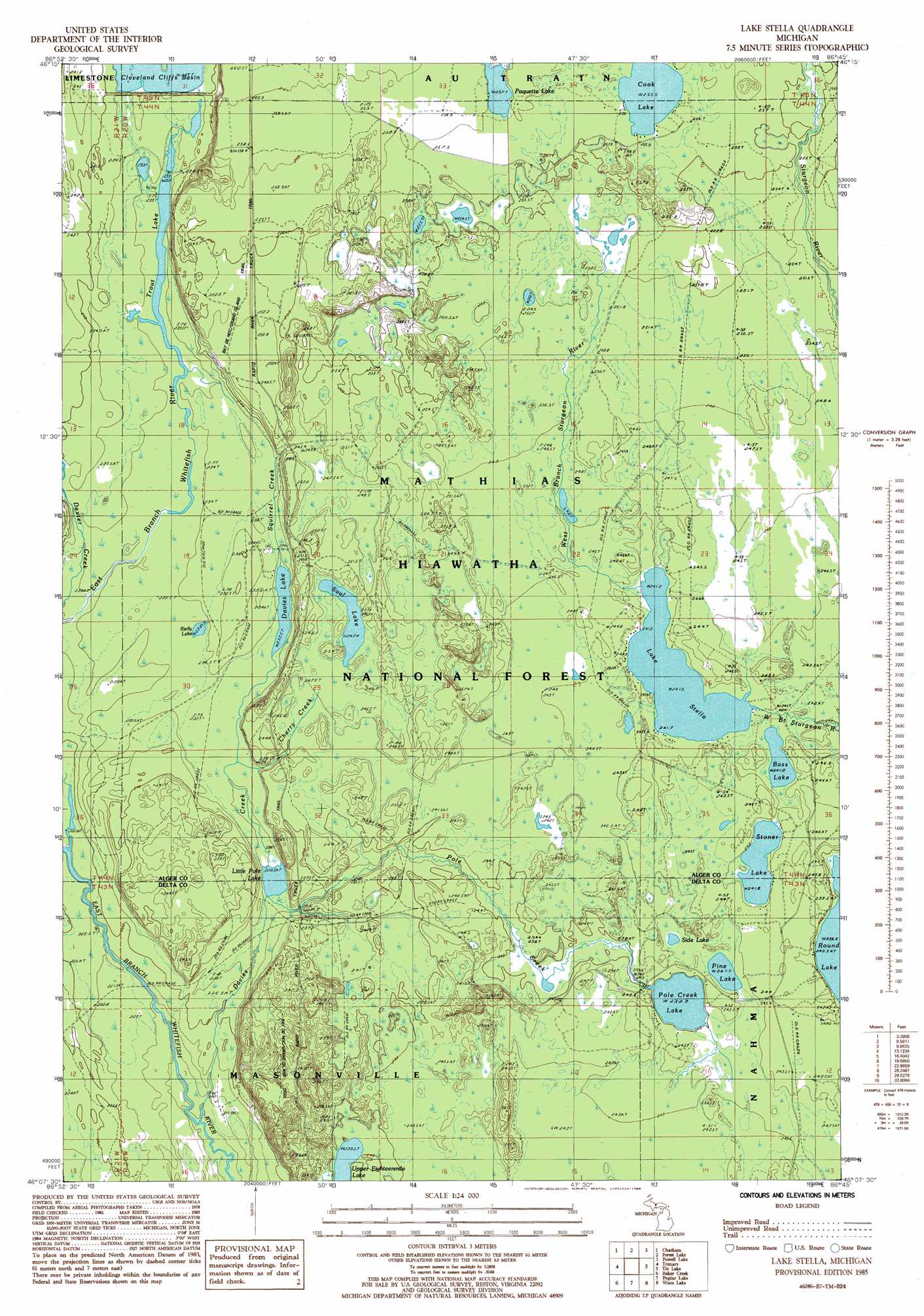
USGS Topo Quad 46086b7 - 1:24,000 scale
| Topo Map Name: | Lake Stella |
| USGS Topo Quad ID: | 46086b7 |
| Print Size: | ca. 21 1/4" wide x 27" high |
| Southeast Coordinates: | 46.125° N latitude / 86.75° W longitude |
| Map Center Coordinates: | 46.1875° N latitude / 86.8125° W longitude |
| U.S. State: | MI |
| Filename: | o46086b7.jpg |
| Download Map JPG Image: | Lake Stella topo map 1:24,000 scale |
| Map Type: | Topographic |
| Topo Series: | 7.5´ |
| Map Scale: | 1:24,000 |
| Source of Map Images: | United States Geological Survey (USGS) |
| Alternate Map Versions: |
Lake Stella MI 1985, updated 1985 Download PDF Buy paper map Lake Stella MI 1985, updated 1985 Download PDF Buy paper map Lake Stella MI 2011 Download PDF Buy paper map Lake Stella MI 2014 Download PDF Buy paper map Lake Stella MI 2017 Download PDF Buy paper map |
| FStopo: | US Forest Service topo Lake Stella is available: Download FStopo PDF Download FStopo TIF |
1:24,000 Topo Quads surrounding Lake Stella
Sand River |
Rock River |
Au Train |
Munsing |
Indian Town |
Ladoga |
Chatham |
Forest Lake |
Powell Lake |
Juniper |
Diffin |
Trenary |
Lake Stella |
The Lake |
Corner Lake |
Rock Se |
Baker Creek |
Poplar Lake |
Waco Lake |
Gooseneck Lake |
Perkins |
Rapid River |
Ensign |
Saint Jacques |
Garden Corners |
> Back to 46086a1 at 1:100,000 scale
> Back to 46086a1 at 1:250,000 scale
> Back to U.S. Topo Maps home
Lake Stella topo map: Gazetteer
Lake Stella: Lakes
Bass Lake elevation 242m 793′Cook Lake elevation 256m 839′
Davies Lake elevation 234m 767′
Lake Stella elevation 241m 790′
Little Pole Lake elevation 229m 751′
Paquette Lake elevation 257m 843′
Pine Lake elevation 240m 787′
Pole Creek Lake elevation 239m 784′
Rielly Lake elevation 233m 764′
Saul Lake elevation 243m 797′
Side Lake elevation 242m 793′
Stoner Lake elevation 242m 793′
Trout Lake elevation 233m 764′
Upper Eighteenmile Lake elevation 240m 787′
Lake Stella: Streams
Cherry Creek elevation 232m 761′Davies Creek elevation 212m 695′
Pole Creek elevation 229m 751′
Squirrel Creek elevation 234m 767′
Lake Stella digital topo map on disk
Buy this Lake Stella topo map showing relief, roads, GPS coordinates and other geographical features, as a high-resolution digital map file on DVD: