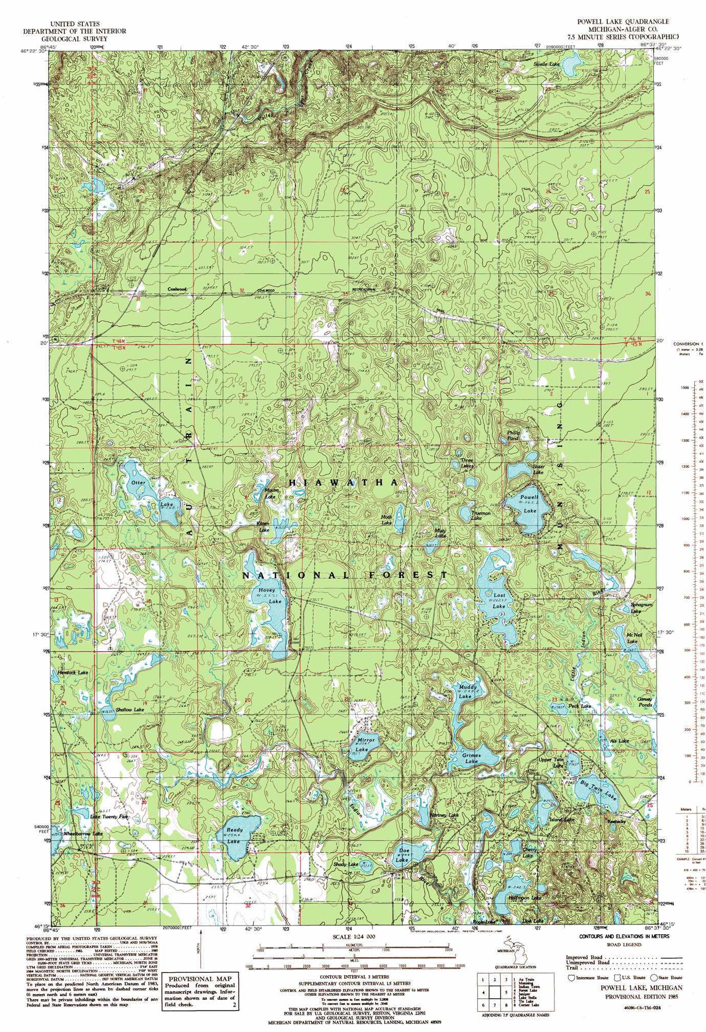
Powell Lake Topo Map Michigan
To zoom in, hover over the map of Powell Lake
USGS Topo Quad 46086c6 - 1:24,000 scale
| Topo Map Name: | Powell Lake |
| USGS Topo Quad ID: | 46086c6 |
| Print Size: | ca. 21 1/4" wide x 27" high |
| Southeast Coordinates: | 46.25° N latitude / 86.625° W longitude |
| Map Center Coordinates: | 46.3125° N latitude / 86.6875° W longitude |
| U.S. State: | MI |
| Filename: | o46086c6.jpg |
| Download Map JPG Image: | Powell Lake topo map 1:24,000 scale |
| Map Type: | Topographic |
| Topo Series: | 7.5´ |
| Map Scale: | 1:24,000 |
| Source of Map Images: | United States Geological Survey (USGS) |
| Alternate Map Versions: |
Powell Lake MI 1985, updated 1985 Download PDF Buy paper map Powell Lake MI 2011 Download PDF Buy paper map Powell Lake MI 2014 Download PDF Buy paper map Powell Lake MI 2017 Download PDF Buy paper map |
| FStopo: | US Forest Service topo Powell Lake is available: Download FStopo PDF Download FStopo TIF |
1:24,000 Topo Quads surrounding Powell Lake
Laughing Fish Point |
Wood Island |
Wood Island Se |
Grand Portal Point |
|
Rock River |
Au Train |
Munsing |
Indian Town |
Melstrand |
Chatham |
Forest Lake |
Powell Lake |
Juniper |
Shingleton |
Trenary |
Lake Stella |
The Lake |
Corner Lake |
Steuben |
Baker Creek |
Poplar Lake |
Waco Lake |
Gooseneck Lake |
Thunder Lake |
> Back to 46086a1 at 1:100,000 scale
> Back to 46086a1 at 1:250,000 scale
> Back to U.S. Topo Maps home
Powell Lake topo map: Gazetteer
Powell Lake: Lakes
Als Lake elevation 257m 843′Big Twin Lake elevation 255m 836′
Cherry Lake elevation 248m 813′
Doe Lake elevation 243m 797′
Grimes Lake elevation 249m 816′
Halfmoon Lake elevation 241m 790′
Hartney Lake elevation 245m 803′
Hemlock Lake elevation 267m 875′
Hovey Lake elevation 254m 833′
Kitten Lake elevation 265m 869′
Lake Twenty Five elevation 256m 839′
Lost Lake elevation 262m 859′
McNeil Lake elevation 260m 853′
Mirror Lake elevation 253m 830′
Misty Lake elevation 262m 859′
Moth Lake elevation 266m 872′
Mouse Lake elevation 267m 875′
Muddy Lake elevation 249m 816′
Otter Lake elevation 268m 879′
Peck Lake elevation 257m 843′
Phillip Pond elevation 267m 875′
Powell Lake elevation 262m 859′
Ready Lake elevation 253m 830′
Shady Lake elevation 253m 830′
Shallow Lake elevation 262m 859′
Sister Lake elevation 265m 869′
Sphagnum Lake elevation 264m 866′
Swede Lake elevation 262m 859′
Three Lakes elevation 265m 869′
Trueman Lake elevation 265m 869′
Upper Twin Lake elevation 255m 836′
Powell Lake: Populated Places
Coalwood elevation 307m 1007′Kentucky elevation 261m 856′
Powell Lake: Post Offices
Coalwood Post Office (historical) elevation 307m 1007′Powell Lake: Streams
Island Lake elevation 251m 823′Powell Lake: Trails
Coalwood Recreational Trail elevation 288m 944′Valley Spur Ski Trail elevation 274m 898′
Powell Lake digital topo map on disk
Buy this Powell Lake topo map showing relief, roads, GPS coordinates and other geographical features, as a high-resolution digital map file on DVD: